| Monday | Monday Night | Tuesday | |
|---|---|---|---|
| Cloud Cover: | Mostly clear | Clear | Mostly cloudy |
| Temperatures: | 30 to 35 deg. F. | 10 to 20 deg. F. | 27 to 32 deg. F. |
| Wind Direction: | SW | SE | E |
| Wind Speed: | 5 to 10 | 5 to 10 | 5 to 15 |
| Snowfall: | 0 in. | 0 in. | 0 in. |
| Snow Line: | 3000 | 3000 | 2500 |
Flathead Range and Glacier National Park
How to read the forecast
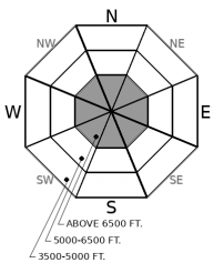
Recent observations from this zone clearly indicate that it's still possible to trigger a large, dangerous avalanche at upper elevations. Not every steep slope, but enough to warrant careful travel. Several parties have reported backing off planned objectives in the past few days. Pick ascent routes that minimize your time below steep start zones, even those high above you. On your descents, choose lines that steer around likely trigger points and away from potential terrain traps.

2. Moderate
?
Above 6500 ft.
1. Low
?
5000-6500 ft.
1. Low
?
3500-5000 ft.
- 1. Low
- 2. Moderate
- 3. Considerable
- 4. High
- 5. Extreme
-
Type ?
-
Aspect/Elevation ?

-
Likelihood ?CertainVery LikelyLikelyPossible
 Unlikely
 -
Size ?HistoricVery LargeLargeSmall

Like a large carnivore that's losing habitat, the Persistent Slab avalanche problem is growing more isolated to high, wild country in Glacier National Park and the Flathead Range. The terrain where you're most likely to trigger a large, dangerous avalanche is near ridges or summits. On many of these slopes, winds have alternately scoured or drifted snow, creating slabs of variable thickness over weak snow that formed early season. Avoid this terrain, or pick your lines carefully to avoid likely trigger points and stay away from potential terrain traps.
The paradise or purgatory weather continues. Blue skies and sun up high while it’s grey and cold below the mid-elevation clouds. For now, these conditions are helping the snowpack consolidate and strengthen. The likelihood of triggering slides is diminishing as fewer slopes become sensitive to the weight of a person or snowmobile. Stepping out into more consequential terrain seems reasonable.
But…of course that “but” was coming. But… there are still slopes where you can trigger large avalanches that break on weak faceted snow near the ground or around midpack crusts or weak layers. Likely candidates are upper elevation slopes near ridgelines with variable snow depths, a convex shape (steeper in the middle), and rocks or rock outcrops that break the snow surface. Avoiding this terrain is a straightforward way to reduce your exposure to the Persistent Slab avalanche problem. If you do step out into terrain like this, pick your lines carefully before dropping in or climbing up. Choose runs on planar slopes that aren’t above terrain traps, like gullies or trees. Steer around likely trigger points and plan an escape route before committing.
Observations in the past week show some distinct differences between the eastern and western parts of the forecast region. We haven’t had reports of triggered Persistent Slab avalanches in the Swan or Whitefish Ranges in a week, and the last report involved a large trigger (cornice) in very steep terrain in the southern part of the zone. We've had one report of shooting cracks in the northern part of the range.
However, it’s a different story in the Flathead Range and Glacier Park. With good visibility the past few days, people have reported the crowns of several large or very large natural avalanches that ran in the past week. We’ve had reports of whumpfing collapses and propagating test results in the past few days. It’s clear that persistent weak layers are not dormant in this region; they’re more widespread and more likely to fail under the weight of a person or snowmachine. Thus, a higher danger rating at upper elevations in the Flathead Range and Glacier National Park.
EDUCATION: We are offering the following upcoming classes: Ladies Introduction to Avalanches Class 01/17/2019 to 01/19/2019, Ladies Avalanche Awareness Talk - Kalispell Brewing Company -01/30/2019 6:30 PM, Motorized Introduction to Avalanches 01/31/2019 to 02/02/2019, Companion Rescue Clinic 02/09/2019 and Introduction to Avalanches (non-motorized) 02/28/2019 to 03/02/2019.
Inversions continue, with mild conditions above the cloud deck (5-6000 feet). Upper elevation temperatures cool and winds veer to the east as cooler air pushes over the divide tonight. Incoming storms may break this pattern later in the week.
This forecast applies only to backcountry areas outside established ski area boundaries. The forecast describes general avalanche conditions and local variations always occur. This forecast expires at midnight on the posted day unless otherwise noted. The information in this forecast is provided by the USDA Forest Service who is solely responsible for its content.


