| Sunday | Sunday Night | Monday | |
|---|---|---|---|
| Cloud Cover: | Mostly clear | Clear | Mostly clear |
| Temperatures: | 30 to 35 deg. F. | 18 to 24 deg. F. | 29 to 34 deg. F. |
| Wind Direction: | SW | SW | SW |
| Wind Speed: | 5 to 10 | 5 to 10 | 5 to 10 |
| Snowfall: | 0 in. | 0 in. | 0 in. |
| Snow Line: | 3000 | 3000 | 3000 |
Whitefish Range
Swan Range
Flathead Range and Glacier National Park
How to read the forecast
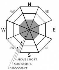
The mountains will bask in warm and sunny conditions above the valley clouds. While the fair weather helps our snowpack strengthen, reports of collapsing and propagation confirm that we still have a Persistent Slab avalanche problem at upper elevations. Terrain selection remains the solution to this complex problem. Planar slopes with a deep uniform snow cover are a better choice than steep rocky areas harboring a variable snowpack depth.

2. Moderate
?
Above 6500 ft.
1. Low
?
5000-6500 ft.
1. Low
?
3500-5000 ft.
- 1. Low
- 2. Moderate
- 3. Considerable
- 4. High
- 5. Extreme
-
Type ?
-
Aspect/Elevation ?

-
Likelihood ?CertainVery LikelyLikelyPossible
 Unlikely
 -
Size ?HistoricVery LargeLargeSmall

Despite bluebird conditions, we remain concerned about old slabs resting on buried weak layers. A Persistent Slab snow structure is still found in areas harboring a thin snowpack. Collapsing and propagation yesterday in southern Glacier Park confirms this problem. Persistent slabs surprise us with remote triggering that fracture above the rider. Terrain management is the solution for managing this complex problem. Choose planar slopes harboring a thick uniform snowpack. Steep rocky convex terrain with a variable snow depth is suspect.
A strengthening inversion will offer another day of sunshine and mild temperatures above the valley clouds. Warm conditions continue to strengthen our snowpack but weak layers formed earlier this season are slow to heal. Areas with a notoriously weak snowpack continue to tell us that the Persistent Slab problem is still a concern. Observations yesterday from southern Glacier Park included collapsing and snowpit stability tests which propagated on these weak layers. Red flags like these are becoming increasingly rare illustrating that this problem is healing in many locations. Despite the isolated nature of this problem, a rider could still trigger an avalanche on buried weak layers. Likely areas for triggering are where the slab thins. This is why we emphasize staying away from steep rocky terrain which is a minefield of trigger points. The same can be said for areas cross-loaded or scoured by the wind leaving a slope with widely varying snow depths. Choosing planar well-supported slopes with uniform snow coverage is still the best option.
EDUCATION: We are offering the following upcoming classes: Ladies Introduction to Avalanches Class 01/17/2019 to 01/19/2019, Ladies Avalanche Awareness Talk - Kalispell Brewing Company -01/30/2019 6:30 PM, Motorized Introduction to Avalanches 01/31/2019 to 02/02/2019, Companion Rescue Clinic 02/09/2019 and Introduction to Avalanches (non-motorized) 02/28/2019 to 03/02/2019.
Strengthening valley inversions and dry mountain conditions will remain through Tuesday. Expect sunny conditions and mild temperatures above the valley clouds.
This forecast applies only to backcountry areas outside established ski area boundaries. The forecast describes general avalanche conditions and local variations always occur. This forecast expires at midnight on the posted day unless otherwise noted. The information in this forecast is provided by the USDA Forest Service who is solely responsible for its content.


