| Wednesday | Wednesday Night | Thursday | |
|---|---|---|---|
| Cloud Cover: | Overcast | Mostly Cloudy | Mostly Cloudy |
| Temperatures: | 31 to 36 deg. F. | 25 to 30 deg. F. | 29 to 39 deg. F. |
| Wind Direction: | Southwest | Southwest | Southwest |
| Wind Speed: | 5 to 15 mph, gusting to 25 | 5 to 15 mph, gusting to 35 | 10 to 20 mph, gusting to 35 |
| Snowfall: | 1-3" in. | 1 to 4 in. | 1 to 5 in. |
| Snow Line: | 3500 ft | 4500 ft | 4000 ft |
Whitefish Range
Swan Range
How to read the forecast
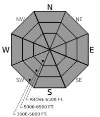
Spoiler alert! Yesterday's fluffy powder just got capped by a few inches of moist, heavy snow and warming temperatures. Shallow sluffs and thin slabs will be common. Stay heads up around terrain traps and long-running gullies at all elevations. Deep weak layers continue to make noise, particularly in alpine terrain in the Flathead Range and Glacier Park.

2. Moderate
?
Above 6500 ft.
2. Moderate
?
5000-6500 ft.
2. Moderate
?
3500-5000 ft.
- 1. Low
- 2. Moderate
- 3. Considerable
- 4. High
- 5. Extreme
-
Type ?
-
Aspect/Elevation ?

-
Likelihood ?CertainVery LikelyLikelyPossible
 Unlikely
 -
Size ?HistoricVery LargeLargeSmall

A few inches of dense or moist snow accumulated last night with a few more inches and warming temperatures in the forecast today. This will deteriorate stability near the snow surface, causing very thin storm slabs or moist, loose sluffs that entrain drier snow below. This problem is easy to identify by looking for surface clues such as cracking, rollerballs, pinwheels, or adjacent avalanche activity. These small slides are generally harmless unless they push you into trees, over rocks, or funnel debris into gullies. Stay alert in that type of terrain.
-
Type ?
-
Aspect/Elevation ?

-
Likelihood ?CertainVery LikelyLikelyPossible
 Unlikely
 -
Size ?HistoricVery LargeLargeSmall

Monday's storm produced numerous persistent slab avalanches that broke several feet deep in the Flathead Range. Observers have reported fewer signs of instability or avalanche activity of this type in the Whitefish and Swan Range. In isolated areas, old, thick slabs over deeply buried weak layers remain a concern under continued snowfall and warming temperatures. They can be triggered naturally by cornice falls, slides in the upper snowpack, or by a single rider who finds the sweet spot on the wrong slope. Reduce your risk to this problem by choosing terrain with a deep, uniform snowpack. Steer away from steep, rocky convex terrain, especially in the alpine. Collapses or whumpfs are clear signs to avoid undercutting or traveling on avalanche terrain.
You'll notice we raised the danger at lower and mid-elevations today, while upper elevations continue to downtrend. Storm snow from earlier in the week is quickly healing: observers yesterday reported minor cracking in the foot of snow + wind that finished on Monday evening. However, a new instability is in the making now, a smaller, wetter one. A few inches of snow accumulated last night with temperatures at or above freezing. This top heavy snow is likely to cause shallow instabilities breaking in the top few inches of the snow surface: a hybrid of thin storm slabs, wet loose avalanches, and dry loose avalanches depending on your elevation and the type of precipitation that is falling. All of these problems are relatively small and easy to manage, but they could get you into trouble in consequential terrain. Be smart around gullies and above cliffs.
Monday's storm produced another round of natural persistent slabs in the mountains around Essex, consistent with the patterns we observed with the previous cycle last week. Slabs are breaking several feet thick in steep, rocky terrain with variable snow depths. An observer above John F Stevens Canyon yesterday reported numerous audible collapses and propagating test results in this same type of terrain: thin, rocky, shallow, variable. Remember those words and put them on your no-go list today. We have observed stronger, unreactive pit results and no recent signs of instabilities in terrain that holds deep, uniform snow coverage. With temperatures rising above freezing today, keep in mind a natural or human-triggered cornice fall can act as a trigger on suspect alpine slopes. This was the scenario that buried and severely injured someone in the Swan Range last Saturday (Accident report here).
EDUCATION: We are offering the following upcoming classes: An Avalanche Awareness talk on Thursday, January 10 at The Stonefly Lounge at 7:00 p.m., a Motorized Level 1- Avalanche Fundamentals course on January 11-13, and a Ladies Introduction to Avalanches January 17 and 19
A "wintry mix" of light precipitation continues today under a warming trend, with a moderate alpine winds.
This forecast applies only to backcountry areas outside established ski area boundaries. The forecast describes general avalanche conditions and local variations always occur. This forecast expires at midnight on the posted day unless otherwise noted. The information in this forecast is provided by the USDA Forest Service who is solely responsible for its content.


