| Sunday | Sunday Night | Monday | |
|---|---|---|---|
| Cloud Cover: | Mostly cloudy | Mostly Cloudy | Mostly Cloudy |
| Temperatures: | 30 to 35 deg. F. | 18 to 23 deg. F. | 35 to 30 deg. F. |
| Wind Direction: | Southwest | Southwest | Southwest |
| Wind Speed: | 5 to 10 mph, gusting to 20 | 10 to 15 mph, gusting to 25 | 20 to 25 mph, gusting to 35 |
| Snowfall: | 2 to 4 in. | 2 to 4 in. | 5 to 10 in. |
| Snow Line: | 2500 ft | 2000 ft | 2000 ft |
Whitefish Range
Swan Range
Flathead Range and Glacier National Park
How to read the forecast
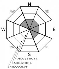
Expect rising hazard at upper elevations. Strong southwest winds and light snow will form thin slabs on leeward slopes beneath ridgelines and areas exposed to cross-loading. Be cognizant of blowing snow and fresh drifts as you gain elevation. Steep rocky slopes with a variable snow depth remain capable of producing a large avalanche. Select planar or concave terrain with a consistent snow depth to avoid this problem.

2. Moderate
?
Above 6500 ft.
1. Low
?
5000-6500 ft.
1. Low
?
3500-5000 ft.
- 1. Low
- 2. Moderate
- 3. Considerable
- 4. High
- 5. Extreme
-
Type ?
-
Aspect/Elevation ?

-
Likelihood ?CertainVery LikelyLikelyPossible
 Unlikely
 -
Size ?HistoricVery LargeLargeSmall

Light snow and strong southwest winds will form thin slabs on leeward and cross-loaded slopes today. This problem will be generally confined to upper elevations but may be found on mid-elevation slopes susceptible to cross-loading. Surface cracking in fresh slabs is a sign of instability. Look for areas of blowing snow and signs of fresh drifting such as cornices and pillows.
-
Type ?
-
Aspect/Elevation ?

-
Likelihood ?CertainVery LikelyLikelyPossible
 Unlikely
 -
Size ?HistoricVery LargeLargeSmall

Buried weak snow can still be found in our area and triggering a Persistent slab avalanche remains a low likelihood, high consequence concern. This weak snow structure exists in areas with a thin snowpack often associated with wind scouring. Terrain selection is the easiest and safest way to manage this problem. Steer clear of steep convex rocky terrain where triggering a slide is most likely.
Yesterday's warm sunny conditions and calm to light winds strengthened recently formed wind slabs. This was noted during FAC staff observations from interior Glacier Park and the eastern portion of our zone. A weather system entering our area this morning will increase the avalanche hazard at upper elevations due to forecasted light snow and strong winds. A new generation of wind slabs will form on leeward and cross-loaded slopes at upper elevations with thin slab formation that will thicken throughout the day. In areas susceptible to cross-loading these slabs may be found at mid-elevations. Evaluate the thickness of fresh slabs and look for areas of fresh drifting.
A more impressive system enters our area tonight with current snow totals upwards of a foot expected. Expect the avalanche danger to rise with new storm slab formation.
We received information this morning that a snowbiker was caught and injured in the Swan Range yesterday. We have limited details regarding this incident but will provide updates as information becomes available.
Unfortunately, we just received word that an avalanche fatality occurred yesterday outside of Choteau. Preliminary information is that the individual was in a snowmobile group and not wearing an avalanche transceiver. Our condolences go out to the victims family and friends. FAC staff is traveling to the site to conduct an investigation today.
EDUCATION: We are offering the following upcoming classes: An Avalanche Awareness talk on Thursday, January 10 at The Stonefly Lounge at 7:00 p.m., A Motorized Level 1- Avalanche Fundamentals course on January 11-13, and a Ladies Introduction to Avalanches January 17 and 19
.
A weak weather system enters our area today with light snow and strong winds. Expect a wintry mix in valley locations. Tonight and tomorrow a stronger system enters our area with moderate snow.
This forecast applies only to backcountry areas outside established ski area boundaries. The forecast describes general avalanche conditions and local variations always occur. This forecast expires at midnight on the posted day unless otherwise noted. The information in this forecast is provided by the USDA Forest Service who is solely responsible for its content.


