| Saturday | Saturday Night | Sunday | |
|---|---|---|---|
| Cloud Cover: | Partly cloudy | Mostly Cloudy | Mostly Cloudy |
| Temperatures: | 30 to 35 deg. F. | 18 to 23 deg. F. | 35 to 30 deg. F. |
| Wind Direction: | South | South | Southwest |
| Wind Speed: | 5 to 10 mph, gusting to 20 | 10 to 15 mph, gusting to 25 | 20 to 25 mph, gusting to 35 |
| Snowfall: | 0 in. | 0 to 1 in. | 3 to 5 in. |
| Snow Line: | 3500 ft | 3000 ft | 2500 ft |
Whitefish Range
Swan Range
Flathead Range and Glacier National Park
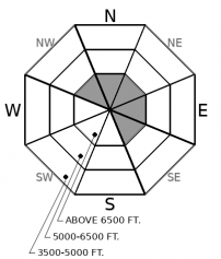
How to read the forecast
Recently-formed slabs of drifted snow continue to pose a hazard on leeward slopes near ridgelines and on open slopes exposed to cross-loading. In this terrain, pick your way around start zones with signs of recent drifting, like cornices. Large avalanches that break in old snow remain a concern on steep slopes with variable snow depths. The unpredictibility of this hazard makes avoiding this terrain the most straightforward way to reduce your exposure.

2. Moderate
?
Above 6500 ft.
1. Low
?
5000-6500 ft.
1. Low
?
3500-5000 ft.
- 1. Low
- 2. Moderate
- 3. Considerable
- 4. High
- 5. Extreme
-
Type ?
-
Aspect/Elevation ?

-
Likelihood ?CertainVery LikelyLikelyPossible
 Unlikely
 -
Size ?HistoricVery LargeLargeSmall

Look for recently-formed slabs of drifted snow on leeward and cross-loaded slopes today. These will be thicker and more extensive at upper elevations; they pose a hazard on isolated slopes at mid-elevations. Avoid undercutting steep slopes, like gully walls or slopes below cornices.
-
Type ?
-
Aspect/Elevation ?

-
Likelihood ?CertainVery LikelyLikelyPossible
 Unlikely
 -
Size ?HistoricVery LargeLargeSmall

It’s still possible to trigger large slides that break several feet deep on old weak layers. The likelihood of triggering these slides is highest on convex slopes with shallow snow cover, multiple trigger points, and recent accumulations of drifted snow. Give this terrain a wide berth.
The most serious avalanche concern remains the hazard of triggering a slide that breaks in layers of old, weak snow. The most active of these recently has been facets near the ground, though there are also layers of facets and surface hoar buried midpack. Recent natural avalanche activity (southern Flathead Range, John F. Stevens Canyon) attests to the size and lingering hazard slides like this pose.
The potential for triggering slides on these layers is what’s dictating where and how I ride. It means steep slopes (greater than about 35 degrees) with rock outcrops and variable snow depths are off-limits, because the snow near the ground is weaker, and thin patches of snow equal potential trigger points. That’s especially true of slopes with a convex shape. While the problem is isolated at mid elevations, it’s a more extensive concern in upper elevation terrain where the weak layers are better developed and have received a greater load of new and drifted snow since New Year’s Day. Whumpfing collapses are a clear sign that this danger exists and isn’t dormant.
Bouts of gusty winds have accompanied this week’s snowfall. These have blown mostly from the southwest, drifting snow onto easterly and northerly slopes below ridgelines. Some small, shallow slabs have formed, and observers have reported triggering small, shallow slides in drifted terrain near ridges and in cross-loaded gullies.
While we may see some moderate to strong gusts today, the winds have generally died enough that slab formation has ended. The likelihood of triggering these slides is diminishing. It’s nonetheless worth looking for these slabs near ridgelines on northerly and easterly slopes, and on the lee sides of gullies on more southerly slopes. If they’re hard – little to no ski or board penetration – they tend to break above you, so slope cuts aren’t an effective or safe tactic. Steer around them instead. Be aware that the debris from small triggered wind slabs may in turn trigger larger, more dangerous Persistent slab avalanches.
Today’s warming temperatures and bouts of sun might create some isolated wet snow avalanche concerns, primarily at mid elevations. Roller balls are a good sign this hazard is developing, and an indication to step back to lower-angled slopes or terrain with drier snow.
A weak, short-lived ridge brings dry and warm conditions to the region today, with light southerly winds. Temperatures may climb above freezing even above 6000 feet. A cold front sweeps through Sunday, accompanied by snow showers and stronger winds.
This forecast applies only to backcountry areas outside established ski area boundaries. The forecast describes general avalanche conditions and local variations always occur. This forecast expires at midnight on the posted day unless otherwise noted. The information in this forecast is provided by the USDA Forest Service who is solely responsible for its content.


