| Wednesday | Wednesday Night | Thursday | |
|---|---|---|---|
| Cloud Cover: | Mostly cloudy | Mostly Cloudy | Mostly Cloudy |
| Temperatures: | 19 to 29 deg. F. | 15 to 25 deg. F. | 25 to 35 deg. F. |
| Wind Direction: | Southwest | Southwest | Southwest |
| Wind Speed: | 15 to 20 mph, gusting to 40 | 20 to 30 mph, gusting to 50 | 20 to 30 mph, gusting to 50 |
| Snowfall: | 0 in. | 0 in. | 1 to 3 in. |
| Snow Line: | 2500 ft | 3000 ft | 3500 ft |
Whitefish Range
Swan Range
Flathead Range and Glacier National Park
How to read the forecast
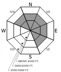
Southwest winds will pick up speed today and form new drifts on leeward aspects. Triggering a wind slab will become increasingly possible by this afternoon. Small avalanches may step down to buried weak layers resulting in a larger, more destructive avalanche. Carefully evaluate terrain with freshly drifted snow.

2. Moderate
?
Above 6500 ft.
2. Moderate
?
5000-6500 ft.
1. Low
?
3500-5000 ft.
- 1. Low
- 2. Moderate
- 3. Considerable
- 4. High
- 5. Extreme
-
Type ?
-
Aspect/Elevation ?

-
Likelihood ?CertainVery LikelyLikelyPossible
 Unlikely
 -
Size ?HistoricVery LargeLargeSmall

As southwest winds increase throughout the day, they will blow the soft surface snow into denser drifts on leeward slopes. Look for round dunes below cornices and on crossloaded features. Note blowing snow in exposed terrain as a clue that sensitive new wind slabs are forming. Shooting cracks are a direct sign of instability.
-
Type ?
-
Aspect/Elevation ?

-
Likelihood ?CertainVery LikelyLikelyPossible
 Unlikely
 -
Size ?HistoricVery LargeLargeSmall

Buried weak layers at the bottom and middle of our snowpack remain a concern. Observers on Monday saw the kind of large and destructive avalanches that these layers can produce when they are overloaded. Many recent persistent slab avalanches were triggered by smaller wind slabs from above. Snowpack tests in Glacier yesterday showed that these layers are still capable of failure. Persistent slabs can be hard to predict. Managing the problem includes avoiding steep convex slopes and rocky areas with variable coverage. Well supported smooth slopes are a better bet.
If observations from the Essex area are representative, last weekend’s storm resulted in a healthy avalanche cycle. Storm slab and wind slab avalanches stepped down into buried weak layers triggering large and destructive persistent slabs. We estimated that one of these slides was a half-mile wide. And while there has only been light precipitation since Monday night, snowpack tests continue to show that buried weak layers are capable of failure and propagation.
Several inches of light fluffy snow that fell yesterday will provide ammo for new wind slabs today. As winds increase out of the southwest, watch for blowing snow near ridgelines and in exposed terrain. New drifts will be round or pillow-shaped and can crack under skis or snowmobiles which is a direct sign of instability. Be aware that triggering even a small wind slab may result in a larger avalanche if the buried weak layers become overloaded. On sheltered slopes you are more likely to find softer snow that’s safer and more fun to ride.
Light snow flurries will continue under cloudy skies today. Winds and temperatures will creep upward throughout the day ahead of more light precipitation tomorrow night.
This forecast applies only to backcountry areas outside established ski area boundaries. The forecast describes general avalanche conditions and local variations always occur. This forecast expires at midnight on the posted day unless otherwise noted. The information in this forecast is provided by the USDA Forest Service who is solely responsible for its content.


