| Saturday | Saturday Night | Sunday | |
|---|---|---|---|
| Cloud Cover: | Overcast | Overcast | Mostly cloudy |
| Temperatures: | 28 to 33 deg. F. | 16 to 21 deg. F. | 20 to 25 deg. F. |
| Wind Direction: | Southwest | Southwest | Northwest |
| Wind Speed: | 15 to 25 mph, gusting to 45 this afternoon | 15 to 25 mph, gusting to 45 | 5 to 15 mph |
| Snowfall: | 3 to 6" in. | 7 to 11" in. | 2 to 4" in. |
| Snow Line: | Rising to 4000 ft | 3500 ft | 1500 ft |
Whitefish Range
Swan Range
Flathead Range and Glacier National Park
How to read the forecast
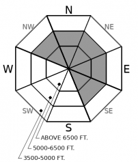
Its snowing and blowing and the avalanche danger will rise to CONSIDERABLE by later today. Natural and human triggered avalanches breaking in the new and drifted snow will be the most common hazard. You are most likely to get in trouble where winds are drifting or stiffening the new snow into easily triggered slabs. Smaller slides have potential to step down to old weak layers and initiate larger, more dangerous avalanches.

3. Considerable
?
Above 6500 ft.
2. Moderate
?
5000-6500 ft.
1. Low
?
3500-5000 ft.
- 1. Low
- 2. Moderate
- 3. Considerable
- 4. High
- 5. Extreme
-
Type ?
-
Aspect/Elevation ?

-
Likelihood ?CertainVery LikelyLikelyPossible
 Unlikely
 -
Size ?HistoricVery LargeLargeSmall

5" to 10" of new snow overnight and through today will quickly drift into tender soft slabs as winds increase this afternoon. Although these slabs are relatively small this morning, they will grow in size through the day and can entrain enough snow to injure or bury you as they gain volume running down steep terrain. Blowing snow near ridgelines, stiffening surfaces conditions, or cracking under your foot or machine are signs of hazard. Avoid traveling on or below steep leeward or crossloaded terrain features.
-
Type ?
-
Aspect/Elevation ?

-
Likelihood ?CertainVery LikelyLikelyPossible
 Unlikely
 -
Size ?HistoricVery LargeLargeSmall

The sensitivity of persistent slabs will increase through the day into tomorrow as new snow and windloading add stress to buried weak layers lurking in the middle and bottom of the snowpack. Collapses or "whumpfs" are glaring signs that the snowpack is unstable, pointing you towards slopes less than 30 degrees. Avoid terrain being loaded by wind-transported snow and be wary of slopes with thin and variable snow coverage. Small slides in the upper snowpack can act as triggers for deeper weak layers.
The mountains picked up 5" to 8" of low-density snow since yesterday. Another 3"-6" is on the way today, with a bigger hit coming tonight. Winds have remained relatively tame so far, though some stations are reporting an uptick in southwest winds overnight with gusts into the 20's. This spells fluffy powder riding conditions and sluff management on steep slopes this morning, while isolated and small wind slabs are forming near ridgelines. Conditions will change quickly when wind speeds increase this afternoon. The winds will redistribute the powder into thicker and more widespread slabs as the day progresses. That, paired with warming temperatures, denser snowfall today, and lurking weak layers, are ingredients for dangerous avalanche conditions. Windloaded slopes are most concerning today, but the hazard will become more widespread overnight as continued snowfall builds storm slabs and adds weight to buried weak layers.
Our last rapid loading event resulted in several natural persistent slab avalanches failing near the ground. The .2" to .4" of snow water equivalent that fell overnight isn't an alarming amount just yet, but tonight's snowfall could tip the scales. Today, shallow avalanches in the new snow could entrain enough snow to act as triggers for deeper weak layers. This concern is fairly isolated this morning, but will become more widespread over the next 24 hours.
Moderate snowfall will continue through the day. A cold front this afternoon will increase wind speeds and intensify snowfall rates. Winds relax while mountain temperatures will trend towards zero by Sunday night. Snowfall will wind down by Sunday afternoon.
This forecast applies only to backcountry areas outside established ski area boundaries. The forecast describes general avalanche conditions and local variations always occur. This forecast expires at midnight on the posted day unless otherwise noted. The information in this forecast is provided by the USDA Forest Service who is solely responsible for its content.


