| Friday | Friday Night | Saturday | |
|---|---|---|---|
| Cloud Cover: | Mostly clear | Increasing clouds | Mostly cloudy |
| Temperatures: | 31 to 36 deg. F. | 19 to 24 deg. F. | 31 to 36 deg. F. |
| Wind Direction: | South | Southwest | South |
| Wind Speed: | 10-20 mph, gusting to 35 | 20 -30 mph, gusting to 50 | 20-30 mph, gusting to 50 |
| Snowfall: | 0 in. | 2 to 4" in. | 0 to 2" in. |
| Snow Line: | 6000 ft | 4000 ft | 2000 ft |
Swan Range
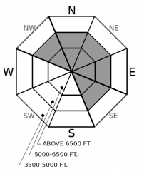
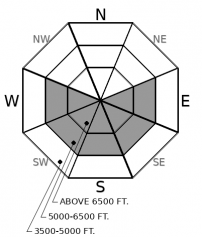
How to read the forecast
Unusually warm and sunny weather could destabilize the snowpack and cause further natural avalanche activity on steep, sunny slopes. In adjacent mountain ranges, reports of skier triggered slides, collapses, shooting cracks, and an avalanche burial yesterday highlight a snowpack that is still adjusting from Tuesday night's storm. Use caution in windloaded terrain, above terrain traps, and below sunbaked faces and gullies today.

2. Moderate
?
Above 6500 ft.
2. Moderate
?
5000-6500 ft.
1. Low
?
3500-5000 ft.
- 1. Low
- 2. Moderate
- 3. Considerable
- 4. High
- 5. Extreme
-
Type ?
-
Aspect/Elevation ?

-
Likelihood ?CertainVery LikelyLikelyPossible
 Unlikely
 -
Size ?HistoricVery LargeLargeSmall

Gusty southwest winds continue to drift and thicken slabs below ridgelines and in leeward terrain features. In adjacent mountain ranges, observers are reporting cracking, collapsing, and human triggered slabs in wind loaded terrain. We have seen fewer signs of instability in the Swan Range, but use caution below leeward ridgelines and in crossloaded slopes. Slabs can break up to several feet thick on buried weak layers that are slow to heal. Watch for cracking in denser snow and avoid thicker, lens-shaped drifts below cornices and in gullies. Choose wind sheltered or lower angle terrain to avoid the problem.
-
Type ?
-
Aspect/Elevation ?

-
Likelihood ?CertainVery LikelyLikelyPossible
 Unlikely
 -
Size ?HistoricVery LargeLargeSmall

Warming temperatures and clearing skies could initiate natural loose snow avalanches as the snow surface moistens on steep, sunbaked terrain. These could entrain enough snow to be dangerous around terrain traps. Pay attention to surface warming: rollerballs, pinwheels, and small sluffs peeling off of rock bands. These are early warning signs to avoid traveling on or below steep sunlit faces and gullies.
The danger is slowly diminishing in the wake of Tuesday night's storm and avalanche cycle, but slides large enough to injure or kill you continue to be triggered in the backcountry. Yesterday, skiers above John F. Stevens Canyon triggered a dense slab of wind drifted snow and reported numerous collapses and shooting cracks. During avalanche mitigation work at Whitefish Mountain Resort, a ski patroller was buried while ski cutting a small slide path (currently closed terrain). His partner performed a quick and effective companion rescue. This observation not only highlights the potential for small terrain to produce surprisingly harsh consequences, but it is a clear reminder to respect terrain closures at the ski resort. This story would have a different ending if it was a solo rider ducking the rope. Unstable slopes like these are becoming less common as our faceted snowpack gradually adjusts to upwards of 2" of SWE and wind loading that has accumulated this week. Windloaded terrain and steep or unsupported rollovers are typically the slowest to heal under these conditions. Be very choosy about which slopes you travel on today and don't allow blue skies to steer your decision making. The avalanche danger is lower in the Swan Range, which picked up less snow this week. Observers have reported fewer signs of instabilities, most of which appear to be localized to wind loaded features.
A notable change adding uncertainty to today's forecast is warming temperatures under sunny skies. Solar warming could moisten the snow and initiate natural sluff avalanches and/or destabilize storm slabs on sunlit aspects. If rapid surface warming conditions develop, avoid traveling on or below steep sunlit gullies and faces where small point releases could entrain dangerous amounts of snow if they run long distances, or they could trigger slab avalanches.
Our next Avalanche Awareness talk is Thursday, December 20th at Penco Power Products at 6:30 p.m.!
Unseasonably warm and sunny weather provides a lull in active weather before the next round of snowfall arrives this evening. We'll see mountain temperatures warming above freezing today. An approaching cold front will bring increasing winds and a decent pulse of snowfall Friday night into Saturday.
This forecast applies only to backcountry areas outside established ski area boundaries. The forecast describes general avalanche conditions and local variations always occur. This forecast expires at midnight on the posted day unless otherwise noted. The information in this forecast is provided by the USDA Forest Service who is solely responsible for its content.


