Whitefish Range
Swan Range
Flathead Range and Glacier National Park
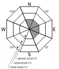
How to read the forecast
An increase in wind speeds accompanied by new snow will form shallow instabilities on high elevation, wind drifted slopes through the weekend. Beware of thin snow coverage and buried obstacles to amplify the consequences of an avalanche. The snowpack is generally too shallow on most mid and lower elevation terrain for avalanche concerns.

No Rating
?
Above 6500 ft.
No Rating
?
5000-6500 ft.
No Rating
?
3500-5000 ft.
-
Type ?
-
Aspect/Elevation ?

-
Size ?HistoricVery LargeLargeSmall

West to southwest winds are forecasted to increase on Friday ahead of 2" to 6" of snow through the weekend. At high elevations, the new and recent snow will drift into deposits below ridgelines, in gullies, and on cross-loaded terrain features. Use caution in steep terrain showing signs of wind slab formation, such as cracking snow, thicker drifts, or pillowy looking snow textures.
Remote weather stations around 6,000' are showing an 18" to 23" snowpack around our forecast area on Friday morning. Observers have reported deeper amounts at some higher elevations in the Swan and Flathead Ranges, and a shallower snowpack in Glacier Park. Our recent field visits to the Northern Whitefish Range, the Southern Flathead Range, and Glacier Park are suggesting a relatively strong snowpack structure up to 3 feet deep is developing at upper elevations. Given our limited field data at this point in the season, we suggest assessing the entire snow structure before traveling in steep terrain. Let us know what you find.
Our primary avalanche concerns going into next week are surface instabilities formed from new snow and wind transport. The snow surface is currently incohesive snow which will easily drift or act as a weak layer below denser snow. If you are traveling at higher elevations, pay attention to new snow amounts and wind drifting patterns. W/SW winds are forecasted to increase to 20 mph, gusting into the 40's on Friday, and up to 6" could accumulate by Saturday favoring the Swan Range. If this forecast verifies, expect to find reactive wind slabs localized to high elevation, leeward and crossloaded terrain features. These will gradually stabilize during calm weather at the beginning of next week. A warmer system looks to arrive by mid-week which could bring storm slab and wind slab concerns to higher elevations.
This is an early season snowpack update. The FAC will continue to monitor conditions and update information as conditions warrant.
We will be producing mountain weather forecasts during our regular season operations. You can find daily backcountry specific weather forecasts from NOAA here.
This advisory applies only to backcountry areas outside established ski area boundaries. This advisory describes general avalanche conditions and local variations always occur. This advisory expires at midnight on the posted day unless otherwise noted. The information in this advisory is provided by the USDA Forest Service who is solely responsible for its content.
Call
Contact
In Partnership With

In Partnership With


