| Thursday | Thursday Night | Friday | |
|---|---|---|---|
| Cloud Cover: | Snow | Snow | Snow ending in the morning with partly to mostly cloudy skies |
| Temperatures: | 30 to 35 deg. F. | 20 to 25 deg. F. | 35 to 40 deg. F. |
| Wind Direction: | E to SE | W | SW |
| Wind Speed: | 5 to 10 mph, gusts 20 mph | 5 to 10 mph, gusts 15 mph | 5 to 10 mph |
| Snowfall: | 4 to 6 in. | 3 to 5 in. | 0 in. |
| Snow Line: |
Whitefish Range
Swan Range
Flathead Range and Glacier National Park
How to read the forecast
New snow and wind on Thursday will begin to form storm slabs at mid and upper elevations. As snow continues, these slabs will thicken and become more widespread. New snow is adding stress to a buried crust/ facet combo that formed earlier in the month. Watch for surface cracking in new snow and lens-shaped pillows on high elevation, leeward slopes. Warmer temps and sunshine on Friday could increase the threat of loose wet avalanches on sunny aspects.

No Rating
?
Above 6500 ft.
No Rating
?
5000-6500 ft.
No Rating
?
3500-5000 ft.
-
Type ?
-
Aspect/Elevation ?

-
Likelihood ?CertainVery LikelyLikelyPossible
 Unlikely
 -
Size ?HistoricVery LargeLargeSmall

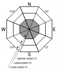
Snowfall begins Thursday and continues through Friday morning with 7-10" of new snow expected with the Swans and the southern Flathead Range favored for over 1 ft. As snow continues, storm slabs will thicken and become more widespread. These slabs are forming over newly formed crust at mid and lower elevations and consolidated or wind-stiffened snow at upper elevations. Storm slabs are a surface problem and instabilities can be evaluated by monitoring snow totals and using hand pits or small test slopes to evaluate new snow bonding. Look for lens-shaped pillows and anticipate deeper drifts on leeward slopes. Cracks in the snow surface is a sign of instability.
-
Type ?
-
Aspect/Elevation ?

-
Likelihood ?CertainVery LikelyLikelyPossible
 Unlikely
 -
Size ?HistoricVery LargeLargeSmall

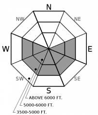
Several persistent slab avalanches (pic 1, pic 2) were observed Wednesday at upper elevations in the southern Flathead Range. These slabs most likely failed on a buried crust/ facet combo that formed earlier this month and is now under a 2-3 ft cohesive slab in some locations. Multiple stability tests this week (ob 1, ob 2, ob 3) produced propagating results on this same layer at both mid and upper elevations. Additional snowfall will be adding stress to this weak layer making human triggering possible over the next 36 hours. Likely trigger locations are where the slab is thinnest or near rock outcrops. Shooting cracks under your feet or machine and audible collapses are warning signs of instability.
-
Type ?
-
Aspect/Elevation ?

-
Likelihood ?CertainVery LikelyLikelyPossible
 Unlikely
 -
Size ?HistoricVery LargeLargeSmall

Thursday's cold and snowy weather should keep the loose wet problem from developing. Cloud models for Friday hint at a possible clearing in the afternoon with temps warming above freezing, especially at mid and lower elevations. New snow and warming temps are ideal ingredients for loose wet avalanches (pic 1, pic 2). If the sun comes out and moistens the snow surface, the potential for shallow wet sluffs will increase. Pinwheels or rollerballs are signs of decreasing stability and suggest its time to move to colder snow or lower angled slopes. These slides are most dangerous in long-running gullies or above cliffs. Anticipate quickly changing conditions if the sun comes out and temps rapidly warm Friday.
Snow and snowpack instabilities are not ready to go into spring hibernation just yet. Snowfall begins Thursday and will start to form shallow storm slabs at mid and upper elevations. We can expect 7-10" of snow by Thursday evening with upwards of 1 ft plus in favored locations of the Swans and the southern Flathead Range. These slabs will thicken and become more widespread as snowfall continues. Snow levels start out around 4500 ft Thursday and lower to around 3000 ft by Thursday evening. These slabs will form on a mix bag of old surface conditions and will be most sensitive during or immediately after snowfall ends. Warmer temps and drier conditions Friday could allow these storms slabs to quickly gain strength. For Thursday, monitor snowfall totals and use small test slopes and hand pits to evaluate bonding with the old snow surface. A storm slab triggered in bigger terrain and running long distances has the potential to step down to a buried crust/ facet combo giving way to an even larger avalanche.
In some areas, snowfall over the past two weeks buried a crust/ facet combo that formed earlier in the month. Warm temps and the combination of rain and snow over the past two days allowed the upper snowpack to further consolidate and stiffen. Most mountain locations below 6000 ft didn’t freeze Tuesday night with only a short time period of below freezing temps above. Several natural avalanches were observed Wednesday in the southern Flathead Range most likely failing on the buried crust/ facet combo, now under a 2-3 ft cohesive slab. These slabs initiated above 6000 ft but you could also encounter this problem at mid elevations. Multiple stability tests this week have also produced propagating test results (video) on this same layer at both mid and upper elevations. The combination of instability in test and natural avalanches means that our persistent slab problem is alive and well and should be evaluated before committing to a slope. If stability is in question, use terrain selection as your answer by avoiding steep, convexities or unsupported slopes.
If the sun makes a stage right appearance Friday, anticipate quickly changing surface conditions. New snow and above freezing temps are ideal ingredients for loose wet sluffs. Use caution when traveling around long-running gullies or around cliff bands where a small sluff could have a bad outcome.
If you and your partners have assessed terrain as appropriate for the day's conditions, apply a few simple travel strategies to reduce your risk. Sometimes we assess stability incorrectly and our safety protocols are the only thing separating a good story from a tragedy.
- Always carry a beacon, shovel, and probe. The odds of a successful companion rescue are limited without them.
- Provide adequate spacing between yourself and your partners as you pass through avalanche terrain. Your partner(s) can't initiate a rescue if they are also buried. Multiple burials require more time and resources with the odds of surviving even lower.
- Keep your eyes on terrain above you and get out of harms way.
Another day, another cold front and more late-season snow are on tap. A strong low-pressure system and associated upper air trough move through the western US over the next 24 hours bringing widespread snow and wind. Temps Thursday will be in the low to mid-30s below 5000 ft and upper 20s above that. Moderate winds speeds and strong gusts along ridgelines can be expected Thursday, especially with cold front passage this afternoon. Precipitation comes to an end around mid-morning Friday with partly to mostly cloudy skies and warmer afternoon temps.
This advisory applies only to backcountry areas outside established ski area boundaries. This advisory describes general avalanche conditions and local variations always occur. This advisory expires at midnight on the posted day unless otherwise noted. The information in this advisory is provided by the USDA Forest Service who is solely responsible for its content.


