| Saturday | Saturday Night | Sunday | |
|---|---|---|---|
| Cloud Cover: | Precipitation developing in the afternoon. | Light snow | Continued precipitation |
| Temperatures: | 39-44 deg. F. | 25-30 deg. F. | 35-40 deg. F. |
| Wind Direction: | SE | SW | SW |
| Wind Speed: | 5 to 10 mph, gusts 25 mph | 5 to 10 mph, gusts to 25 mph | 10 to 15 mph, gusts 30 mph |
| Snowfall: | 0-2 in. | 1-3 in. | 1 to 3 in. |
| Snow Line: |
Whitefish Range
Swan Range
Flathead Range and Glacier National Park
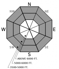
How to read the forecast
This morning the avalanche danger is MODERATE. A warm wet storm will impact our area later today raising the danger to CONSIDERABLE. Wet avalanches will become a concern below the rain line and dense snow will form sensitive slabs above it. Monitor changing conditions and be alert for natural activity later today.

3. Considerable
?
Above 6500 ft.
3. Considerable
?
5000-6500 ft.
2. Moderate
?
3500-5000 ft.
- 1. Low
- 2. Moderate
- 3. Considerable
- 4. High
- 5. Extreme
-
Type ?
-
Aspect/Elevation ?

-
Likelihood ?CertainVery LikelyLikelyPossible
 Unlikely
 -
Size ?HistoricVery LargeLargeSmall

This week 1-2' of snow fell across our area which is resting on a slick crust in many locations. Today's incoming storm is warm and wet with uncertainty regarding freezing levels. Above the rain line, new snow will be dense and create an "upside down" snow surface. Observations from this week report a poor bond between recent snow and the underlying crust. Expect changing conditions later today with the development of sensitive storm slabs. Cracking under your feet or machine is an obvious sign of an unstable slab. Wind-sheltered slopes less than 35 degrees offer the safest riding conditions.
-
Type ?
-
Aspect/Elevation ?

-
Likelihood ?CertainVery LikelyLikelyPossible
 Unlikely
 -
Size ?HistoricVery LargeLargeSmall

This morning the avalanche danger is LOW at low and mid elevations. The danger is expected to rise following the arrival of today's warm storm. Rain on snow along with wet heavy snow may create wet avalanches. There is uncertainty with today's freezing level and this problem will be amplified if the rain line creeps into the middle elevation band where up to 1 foot of new snow is resting on a crust. Expect changing conditions later today with rollerballs and pinwheels being the first signs of instability. Use caution while riding above terrain traps and in long-running gullies.
A potent warm wet atmospheric river is currently impacting much of the western U.S. Fortunately we are on the far northeast corner of this mess and may "only" pick up 1-1.5" of precipitation this weekend. This storm has its origins in the tropics and therefore will be warm. Freezing levels are uncertain but the current forecast is for rain in the low elevations with dense snow above that. If the warm air to our south nudges a bit further to the north the rain line will rise. This week's relatively cold snow will be reactive to rain with wet avalanche activity expected. Today's dense snow will form an inverted snow surface that may be sensitive to human triggering. In many locations, a stout surface crust exists below the new snow and may act as a slippery bed surface. Anticipate changing conditions later today and be alert for natural activity.
The FAC will conclude daily advisories on April 8th. We will publish snowpack updates at 7 a.m. on Tuesday, Thursday, and Saturday mornings next week.
A short break in the precipitation this morning will eventually give way to a vigorous cold frontal passage expected later today across the region. Warm and wet conditions will be with us through Sunday.
This advisory applies only to backcountry areas outside established ski area boundaries. This advisory describes general avalanche conditions and local variations always occur. This advisory expires at midnight on the posted day unless otherwise noted. The information in this advisory is provided by the USDA Forest Service who is solely responsible for its content.


