| Sunday | Sunday Night | Monday | |
|---|---|---|---|
| Cloud Cover: | Increasing clouds with snow developing | Heavy snow and windy | Light snow and windy |
| Temperatures: | 32 to 37 deg. F. | 10 to 15 deg. F. | 25 to 30 deg. F. |
| Wind Direction: | SW | NW | N |
| Wind Speed: | 5 to 15 mph, gusting 25 mph | 10 to 15 gusting to 30 mph | 5 to 10 mph, gusting 20 mph |
| Snowfall: | 1 to 3 in. | 5 to 7 in. | 1 to 3 in. |
| Snow Line: |
Whitefish Range
Swan Range
Flathead Range and Glacier National Park
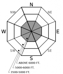
How to read the forecast

1. Low
?
Above 6500 ft.
1. Low
?
5000-6500 ft.
1. Low
?
3500-5000 ft.
- 1. Low
- 2. Moderate
- 3. Considerable
- 4. High
- 5. Extreme
-
Type ?
-
Aspect/Elevation ?

-
Likelihood ?CertainVery LikelyLikelyPossible
 Unlikely
 -
Size ?HistoricVery LargeLargeSmall

Yesterday's dry weather and decreasing winds have allowed recently formed slabs to gain strength. Slabs will be thickest and most reactive closer to the Continental Divide where up to 6" of snow fell Friday night. Look for pillows of snow below ridgelines and in gulley features. Evaluate all steep or convex wind-loaded slopes. Cracking in the snow surface is a sign of instability.
Yesterday, we enjoyed partly sunny skies, decreasing winds, and cool temperatures. This allowed recently formed wind slabs to strengthen but lingering instabilities may remain. Evaluate all wind loaded terrain especially in areas favored by recent snowfall.
Today's big news is no April Fool's Day joke. A potent storm will affect our area later today with heavy snow and gusty southwest winds. The avalanche danger will rise and we expect to reach CONSIDERABLE danger tonight. If this storm arrives earlier than forecast the danger may rise this afternoon. Be alert for changing weather conditions and allow for a change in plans.
If you use our advisories, we encourage you to offer us feedback on this 5-minute survey. For those who participate, we are raffling off a pair of Zeal goggles on April 5th. Thanks!
Gusty westerly winds and mountain snow will once again be on the increase this afternoon across all of the Northern Rockies. Snow levels are expected to be above 4000 feet with the onset of precipitation this afternoon but will quickly lower to below 3000 feet this evening after a cold frontal passage.
This advisory applies only to backcountry areas outside established ski area boundaries. This advisory describes general avalanche conditions and local variations always occur. This advisory expires at midnight on the posted day unless otherwise noted. The information in this advisory is provided by the USDA Forest Service who is solely responsible for its content.


