| Wednesday | Wednesday Night | Thursday | |
|---|---|---|---|
| Cloud Cover: | Isolated showers with a mix of sun and clouds | Cool and partly cloudy | Isolated showers with a mix of sun and clouds |
| Temperatures: | 37 to 42 deg. F. | 17 to 22 deg. F. | 37 to 42 deg. F. |
| Wind Direction: | W | W | W |
| Wind Speed: | 2 to 12 mph | 2 to 12 mph | 2 to 12 mph |
| Snowfall: | 0 in. | 0 in. | 0 in. |
| Snow Line: |
Flathead Range and Glacier National Park
How to read the forecast
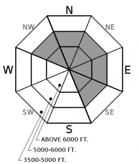
Unusually strong winds have formed tender slabs on leeward terrain features at mid and upper elevations. Yesterday, skiers triggered numerous wind slabs up to several feet thick. Wind protected terrain offers the safest and best riding conditions today.

3. Considerable
?
Above 6500 ft.
2. Moderate
?
5000-6500 ft.
1. Low
?
3500-5000 ft.
- 1. Low
- 2. Moderate
- 3. Considerable
- 4. High
- 5. Extreme
-
Type ?
-
Aspect/Elevation ?

-
Likelihood ?CertainVery LikelyLikelyPossible
 Unlikely
 -
Size ?HistoricVery LargeLargeSmall

Strong to extreme west/southwest winds in the past 24 hours drifted the new snow into thicker slabs at mid and upper elevations. Skiers triggered numerous wind slabs yesterday up to 2 feet thick (see observation), and these slabs grew larger overnight. Avoid traveling in wind loaded terrain. Given unusually strong winds, anticipate larger slabs formed in more locations than you would normally expect. Pay attention to surface clues and steer away from thicker, rounded pillows of snow below ridgelines, in cross-loaded gullies, or behind steep rollovers. Shooting cracks are an obvious sign of instability.
Storm totals alone are an unimpressive 2" to 3", but paired with the water content and wind speeds in the past 24 hours, its easy to understand how dangerously large wind slabs are now lurking in wind loaded terrain. Flattop SNOTEL in Central GNP squeezed out 1.2" of SWE, while stations in the Whitefish, Flathead, and Swan Ranges are reporting .4" to .7" of SWE. Winds were cranking yesterday into last night, with several wind stations reporting sustained 30 mph winds gusting to 50 out of the south to west-southwest. Observers above Skiumah Lake reported surprisingly thick and easily triggered wind slabs forming as low as 5,000' in elevation. Ski patrol at WMR reported 4" to 10" thick drifts with shooting cracks up to 60 feet long, along with a riming event towards the end of the day. I suspect wind slabs may be a bit more stubborn than yesterday, but the size will be larger and not something to tangle with in serious terrain. Give wind slabs a chance to heal by avoiding wind-loaded slopes, and stay alert to unusual drifting patterns in areas that are normally sheltered from the wind.
If you use our advisories, we encourage you to offer us feedback on this 5-minute survey. For those who participate, we are raffling off a pair of Zeal goggles on April 5th. Thanks!
Scattered showers are dissipating this morning under northwest flow. Mountain temperatures will warm from upper 20s to low 30s today under a mix of sun, clouds, and isolated showers. Winds have eased this morning to the teens or less. Mild weather carries into tomorrow and another storm system looks to impact the area on Friday.
This advisory applies only to backcountry areas outside established ski area boundaries. This advisory describes general avalanche conditions and local variations always occur. This advisory expires at midnight on the posted day unless otherwise noted. The information in this advisory is provided by the USDA Forest Service who is solely responsible for its content.


