| Sunday | Sunday Night | Monday | |
|---|---|---|---|
| Cloud Cover: | Clear with increasing clouds | Clouds thickening | Mostly cloudy |
| Temperatures: | 32 to 37 deg. F. | 15 to 20 deg. F. | 33 to 38 deg. F. |
| Wind Direction: | SW | SW | SW |
| Wind Speed: | 1 to 11 mph | 1 to 11 mph | 5 to 15 mph gusting to 25 |
| Snowfall: | 0 in. | 0 in. | 0 to 1 in. |
| Snow Line: |
Whitefish Range
Swan Range
Flathead Range and Glacier National Park
How to read the forecast
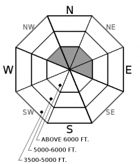
Yesterday's winds formed thin slabs on top of a crust at upper elevations. The snowpack is generally stable on slopes that have not been wind loaded and at lower elevations. Evaluate leeward terrain before committing to a slope.

2. Moderate
?
Above 6500 ft.
1. Low
?
5000-6500 ft.
1. Low
?
3500-5000 ft.
- 1. Low
- 2. Moderate
- 3. Considerable
- 4. High
- 5. Extreme
-
Type ?
-
Aspect/Elevation ?

-
Likelihood ?CertainVery LikelyLikelyPossible
 Unlikely
 -
Size ?HistoricVery LargeLargeSmall

Gusty southwest winds buffeted our area yesterday with Snowslip reporting 10 hours of moderate sustained with strong gusts. With limited snow available for transport slabs will be thin and isolated. Wind slab observations yesterday varied between easy to trigger and stubborn but the size was consistently small. Today expect small pockets of thin slabs resting on a crust or older settled snow on upper elevation leeward aspects. Slabs will be found just below ridgelines or on cross-loaded terrain and may resemble lens-shaped drifts. Hand pits easily identify bonding and reactivity of these features.
Wind sensors in the southern Whitefish Range and John F. Stevens reported consistent blustery conditions yesterday. The reliably windy Hornet station in the northern Whitefish Range has not reported in 24 hours. Snowslip recorded 10 hours of sustained winds above 15 mph with gusts above 25. Fortunately (unfortunately?) these winds had little surface snow to work with and resulting wind slabs are thin. Thursday's warm humid weather formed a melt-freeze crust on shady aspects. Thursday night's weak storm left just 1 to 2" of new snow above 6000' and a rain crust at 6500' in the northern Whitefish Range and 7400' in the eastern Flathead Range. Perhaps 1-3" of snow was deposited yesterday during the cold front passage. Fresh slabs are resting on a crust which will add to their instability. Generally, stable conditions exist at low/mid elevations and at upper elevations not subjected to wind loading.
If you use our advisories, we encourage you to offer us feedback on this 5-minute survey. For those who participate, we're raffling off a pair of Zeal goggles with the drawing April 5th. Thanks!
The Northern Rockies is under a trough of low pressure. Expect scattered snow showers to develop this afternoon. A few showers may be strong and drop a quick inch of snow. Some gusty winds to 30 mph are possible under a shower. Showers will diminish after sunset.
This advisory applies only to backcountry areas outside established ski area boundaries. This advisory describes general avalanche conditions and local variations always occur. This advisory expires at midnight on the posted day unless otherwise noted. The information in this advisory is provided by the USDA Forest Service who is solely responsible for its content.


