| Thursday | Thursday Night | Friday | |
|---|---|---|---|
| Cloud Cover: | Rain with snow levels above 6000' | Rain changing to snow | Partly to mostly cloudy |
| Temperatures: | 40 to 45 deg. F. | 19 to 24 deg. F. | 35 to 40 deg. F. |
| Wind Direction: | SE | SW | SW |
| Wind Speed: | 5 to 10 mph gusting to 23 mph | 10 to 15 mph gusting to 35 mph | 10 to 15 mph gusting to 30 mph |
| Snowfall: | 0 in. | 1 to 2 in. | 0 in. |
| Snow Line: |
Whitefish Range
Swan Range
Flathead Range and Glacier National Park
How to read the forecast
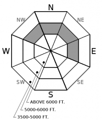
Shady aspects harboring dry snow will be vulnerable to loose wet avalanches today from rain on snow. If rain occurs at upper elevations, the danger there could rise to MODERATE. Rollerballs and pinwheels are initial signs of instability. Use caution around terrain traps and gullies.

1. Low
?
Above 6500 ft.
2. Moderate
?
5000-6500 ft.
1. Low
?
3500-5000 ft.
- 1. Low
- 2. Moderate
- 3. Considerable
- 4. High
- 5. Extreme
-
Type ?
-
Aspect/Elevation ?

-
Likelihood ?CertainVery LikelyLikelyPossible
 Unlikely
 -
Size ?HistoricVery LargeLargeSmall

Dry snow found on shady aspects could become moist and unconsolidated from today’s rain on snow event. Yesterday’s warm temps and sunny skies contributed to a small loose wet avalanche cycle on sunny aspects (ob 1, ob 2), while surface snow remained dry on shady aspects at mid and upper elevations. Look for rollerballs, pinwheels, or point releases from steep, rocky areas as signs of instability. Monitor the rain/ snow line as you move up in elevation and anticipate quickly changing conditions if rainfall intensity increases. Use caution when traveling around terrain traps, gullies, and cliffs.
Yesterday was the first full day of spring and it felt like springtime in the mountains. Sunny skies and warm temps warmed the surface snow on sunny aspects and contributed to a small loose wet cycle. Shady aspects still harbor dry surface snow at mid and upper elevations. Rain on snow could make dry snow vulnerable to loose wet avalanches today. Snow levels are forecasted to rise near 6000 ft but if rain occurs at upper elevations, anticipate loose wet avalanches to develop where deeper new snow amounts exist generally 6 to 15”. Weather models are producing light, liquid precipitation but a heavy burst of rain or graupel and thunderstorms are possible this afternoon. A cold front moves through from west to east dropping snow levels to valley floors overnight. If intense rainfall occurs today, surface conditions could change quickly making loose wet avalanches more widespread. Where dry snow remains, observations continue to report good bonding of recent storm snow with minimal signs of instability. Remain diligent in your snowpack assessments and use caution around terrain traps, gullies, and cliffs with higher consequences.
If you use our advisories, we encourage you to offer us feedback on this 5-minute survey. For those who participate, we're raffling off a pair of Zeal goggles with the drawing April 5th. Thanks!
Warm moist air arrives today on southwest flow rising snow levels to near 6000'. Temps could warm into the 40's F below 5000' and mid to upper 30's F above 5000'. Rain on snow today transitions to snow overnight after a cold front moves through NW Montana from west to east lowering snow levels to valley floors. Rainfall amounts today looks modest (0.03-0.15) but a heavy burst of rain and/ or graupel could occur later in the afternoon. Gusty winds accompany the cold front overnight (30-40 mph) and we could see 2-4" of snowfall by Friday morning.
This advisory applies only to backcountry areas outside established ski area boundaries. This advisory describes general avalanche conditions and local variations always occur. This advisory expires at midnight on the posted day unless otherwise noted. The information in this advisory is provided by the USDA Forest Service who is solely responsible for its content.


