| Thursday | Thursday Night | Friday | |
|---|---|---|---|
| Cloud Cover: | Cloudy with snow developing | Snow | Snow ending midday |
| Temperatures: | 32 to 37 deg. F. | 25 to 30 deg. F. | 32 to 37 deg. F. |
| Wind Direction: | SW | SW | SW |
| Wind Speed: | 5 to 10 mph, gusting 25 mph | 15 to 20 mph, gusting to 35 mph | 15 to 20 mph, gusting to 35 mph |
| Snowfall: | 0 to 1 in. | 2 to 4 in. | 1 to 3 in. |
| Snow Line: |
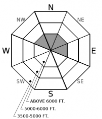
Flathead Range and Glacier National Park
How to read the forecast
New snow and moderate southwest winds will develop shallow wind slabs by this evening at upper elevations on leeward slopes, overlapping with shallow wind slabs that formed yesterday. As snow depths increase, these slabs will thicken and become more widespread; look for cracking in the snow surface as a sign of instability. Generally safer but challenging riding conditions exist in wind-sheltered terrain, where a mix of surface crust or sheltered powder can be found.

2. Moderate
?
Above 6500 ft.
1. Low
?
5000-6500 ft.
1. Low
?
3500-5000 ft.
- 1. Low
- 2. Moderate
- 3. Considerable
- 4. High
- 5. Extreme
-
Type ?
-
Aspect/Elevation ?

-
Likelihood ?CertainVery LikelyLikelyPossible
 Unlikely
 -
Size ?HistoricVery LargeLargeSmall

Moderate southwest winds along with strong gusts accompanied yesterday’s warm, sunny weather in the Flathead Range and GNP. Several observations yesterday (ob 1, ob 2, ob 3, ob 4) found thin, newly formed winds slabs that were reactive to the weight of a skier at upper elevations. These slabs were located directly below ridgelines and on steep convex or cross-loaded terrain features. Additional snow and wind today will overlap with wind slabs that formed yesterday. As snow depths increase today, anticipate these slabs to become thicker and more widespread. Look for cracking in the snow surface as a sign of instability. A small wind slab triggered in high consequence terrain can have a bad outcome.
Sun, warm temperatures, and wind dominated our weather yesterday. Mountain locations warmed into the mid 30’s F with a couple lower elevation stations warming into the mid 40’s F. Numerous observations highlighted lots of pinwheels and rollerballs and a breakable sun crust that develop on sunny aspects in the afternoon. Moderate southwest winds along with strong gusts occurred in the Flathead Range and GNP yesterday forming thin, wind slabs on leeward slopes. Winds eased overnight providing a reprieve in snow transport and loading.
Snow, cooler temperatures, and moderate to strong winds return today. Yesterday’s surface crust will reduce available snow for transport today until snowfall gets going. Snowfall develops by mid-morning with a break in action this afternoon. Snowfall amounts could range between 1-3” today with higher snowfall amounts expected overnight favoring the Swan Range. The break from loading since yesterday afternoon will make wind slabs more stubborn to human triggering to start out the day. Additional snow and wind today will thicken theses slabs and make their distribution more widespread along with increasing the likelihood of human triggering by this evening. Safer but challenging riding conditions exist in lower elevation, wind-sheltered terrain with a mixture of surface crust and sheltered powder.
Deep slab instabilities have been dormant for nearly a month. Continue to give cornices a wide berth; they have grown to dangerously large sizes this season and can also act as triggers for larger avalanches (photo). Cornices are more sensitive to human or natural failures during warm weather like today.
Clouds, snow, and wind will be on the increase during the day today. Generally, light accumulations are expected today with a brief break in action this afternoon before ramping up this evening and Friday morning. Snow levels will rise to 3500-4000 ft today and remain near that elevation range for the duration of the storm. We can anticipate 5-10" of snow by mid-day Friday with locations favored by southwest flow possibly seeing higher amounts.
This advisory applies only to backcountry areas outside established ski area boundaries. This advisory describes general avalanche conditions and local variations always occur. This advisory expires at midnight on the posted day unless otherwise noted. The information in this advisory is provided by the USDA Forest Service who is solely responsible for its content.


