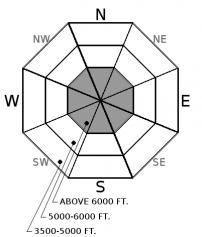
| Monday | Monday Night | Tuesday | |
|---|---|---|---|
| Cloud Cover: | Light snow developing | Snow tapering | Snow dissipating |
| Temperatures: | 24 to 29 deg. F. | 12 to 17 deg. F. | 26 to 31 deg. F. |
| Wind Direction: | W | W | SW |
| Wind Speed: | 1 to 11 mph, gusts to 20 in the Flathead Range | 1 to 11 mph, gusts to 20 in Flathead and Swan Range | 1 to 11 mph |
| Snowfall: | 2 to 4 in. | 1 to 3 in. | 1 to 3 in. |
| Snow Line: |
Whitefish Range
Flathead Range and Glacier National Park
How to read the forecast
Light snow and wind return to our area today. Look for small pockets of new or wind drifted snow on all aspects. A surface crust on sunny aspects will inhibit bonding and act as a slippery bed surface. Stay alert for changing conditions and monitor new snow amounts. Continue to practice safe travel techniques.

1. Low
?
Above 6500 ft.
1. Low
?
5000-6500 ft.
1. Low
?
3500-5000 ft.
- 1. Low
- 2. Moderate
- 3. Considerable
- 4. High
- 5. Extreme
-
Type ?
-
Aspect/Elevation ?

-
Likelihood ?CertainVery LikelyLikelyPossible
 Unlikely
 -
Size ?HistoricVery LargeLargeSmall

Accumulating snowfall and light southwest winds may form thin wind slabs through the day. With just a few inches expected slabs will be thin and confined to upper elevations. Slabs will form on low-density snow on shaded aspects and a sun crust on sunny aspects. Look for pockets of new or wind drifted snow especially on sunny aspects where the crust will act as a slippery bed surface. Thicker lingering wind slabs formed over the weekend may be found in alpine terrain. Cracking in the snow surface is a telltale sign of instability. Utilize hand pits to evaluate the bonding of the new snow to the underlying surface.
Light snowfall started around 5:00 this morning and will continue through the day favoring the Swan Range. Southwest winds will form fresh wind slabs that will thicken through the day. Unlike wind slabs formed over the weekend, today's slabs will form on a crust on sunny aspects where poor bonding may occur. Observations from the weekend in the Flathead, Whitefish and Apgar Range reported no obvious instabilities confirming that today's snow is our concern for the day.
Thank you for your recent observations which always help us produce a better product. Observations can be submitted here: http://www.flatheadavalanche.org/node/add/observation
Due to a sharp decline in local deep slab avalanche activity, supplemented by a lack of explosive results at a regional scale, suggests deep instabilities are dormant under our current weather patterns. We have removed the problem for now but will bring it back when we see another big loading event or spring thaw. Forecasting for deep slabs carries a large amount of uncertainty. We remain uneasy about the potential for a cornice-fall triggered deep slab in the alpine terrain of the Flathead Range and Glacier Park. This blog post provides more insight into the problem.
<
A storm system entered Montana overnight but most of the energy will stay to our south. Expect light snow to develop this morning becoming more widespread through the day. Snowfall will taper overnight into tomorrow with the Swan Range favored.
This advisory applies only to backcountry areas outside established ski area boundaries. This advisory describes general avalanche conditions and local variations always occur. This advisory expires at midnight on the posted day unless otherwise noted. The information in this advisory is provided by the USDA Forest Service who is solely responsible for its content.


