| Wednesday | Wednesday Night | Thursday | |
|---|---|---|---|
| Cloud Cover: | Light snowfall | Snow flurries | Cloudy and warming temperatures |
| Temperatures: | 26 to 31 deg. F. | 15 to 20 deg. F. | 32 to 37 deg. F. |
| Wind Direction: | SW | S | S |
| Wind Speed: | 5 to 15 mph | 5 to 15 mph | 5 to 15 mph |
| Snowfall: | 0 to 2 in. | 0 to 1 in. | 0 in. |
| Snow Line: |
Flathead Range and Glacier National Park
How to read the forecast

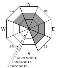
2. Moderate
?
Above 6500 ft.
2. Moderate
?
5000-6500 ft.
1. Low
?
3500-5000 ft.
- 1. Low
- 2. Moderate
- 3. Considerable
- 4. High
- 5. Extreme
-
Type ?
-
Aspect/Elevation ?

-
Likelihood ?CertainVery LikelyLikelyPossible
 Unlikely
 -
Size ?HistoricVery LargeLargeSmall

Gusty southwest winds formed several generations of wind-drifted slabs this week, up to several feet thick. Since Sunday's storm, skiers and riders have triggered wind slabs or reported cracking from leeward slopes every day. Instabilities can be found below corniced ridgelines, in cross-loaded gullies, or behind wind-loaded rollovers. Seek out soft, wind-protected powder and watch for shooting cracks or collapses that warn you of unstable snow.
Southwest wind speeds increased yesterday morning, transporting snow yet again. This was most pronounced in the Flathead Range and Glacier Park, where John F Stevens Canyon saw winds blowing 30 mph and gusting to 50 mph. Observers in the Apgar Range reported fresh drifts that were easily triggered with ski cuts. Watch for smaller, pockety drifts below rollovers or in gullies at mid-elevations, and larger, thicker wind slabs below cornices or in heavily cross-loaded terrain at higher elevations. Meanwhile, on slopes protected from the effects of wind, observers are reporting stable powder riding (such as this observation from the Swan Range or this observation from the Whitefish Range). A few inches of snow overnight and light snow in today's forecast shouldn't change conditions unless we get surprised by more than 6" of new snow.
A sharp decline in local deep slab avalanche activity, supplemented by a lack of explosive results at a regional scale, suggests deep instabilities are dormant under our current weather patterns. We have removed the problem for now but will bring it back when we see another big loading event or spring thaw. Forecasting for deep slabs carries a large amount of uncertainty. We remain uneasy about the potential for a cornice-fall triggered deep slab in the alpine terrain of the Flathead Range and Glacier Park. This blog post provides more insight into the problem.
This morning brings light snowfall, moderate ridgetop winds, and mountain temperatures in the 20s. A low-pressure system stalls on Pacific Coast tomorrow, issuing warmer air but minor precipitation our direction.
This advisory applies only to backcountry areas outside established ski area boundaries. This advisory describes general avalanche conditions and local variations always occur. This advisory expires at midnight on the posted day unless otherwise noted. The information in this advisory is provided by the USDA Forest Service who is solely responsible for its content.


