| Saturday | Saturday Night | Sunday | |
|---|---|---|---|
| Cloud Cover: | Snow | Snow | Snow |
| Temperatures: | 25 to 30 deg. F. | 19 to 24 deg. F. | 27 to 32 deg. F. |
| Wind Direction: | S | SW | SW |
| Wind Speed: | 1 to 11 mph, gusting 25 mph | 5 to 15 mph, gusting 29 | 5 to 10 mph, gusting to 28 |
| Snowfall: | 3 to 5 in. | 3 to 5 in. | 1 to 3 in. |
| Snow Line: |
Swan Range
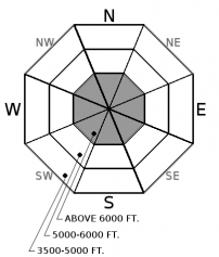
How to read the forecast
Natural and human triggered slides have recently occurred with continued snow and wind forming storm slabs that are likely to be human triggered. Fresh slabs will be thickest and most sensitive to triggering in wind loaded terrain. A variety of crusts and weak layers exist in our snowpack which are being stressed from this weeks loading, posssibly resulting in a very large avalanche. Choosing lower angle non-wind loaded terrain is recommended today with surface cracking/ audible collapses signs of instability.

3. Considerable
?
Above 6500 ft.
2. Moderate
?
5000-6500 ft.
2. Moderate
?
3500-5000 ft.
- 1. Low
- 2. Moderate
- 3. Considerable
- 4. High
- 5. Extreme
-
Type ?
-
Aspect/Elevation ?

-
Likelihood ?CertainVery LikelyLikelyPossible
 Unlikely
 -
Size ?HistoricVery LargeLargeSmall

24 hour snow totals are a modest 2-6" but up to 3.3" of water has been incrementally added to the snowpack over the past 4 days. Wind speeds increased yesterday with substantial snow transport observed in the Flathead Range and Whitefish Range. This combination of snow and wind are adding thickness to storm slabs that formed above a crust (rain, rime, or sun), buried surface hoar, and/ or low density snow. Additional snowfall and wind today will thicken these slabs and stress buried weak layers found 1-3' below the surface with human triggering of storm slabs likely today at upper elevations. Evaluate storm totals, wind-loading and test small slopes before going into steeper terrain while anticipating thicker slabs on leeward features and gullies. Watch for cracking in the new snow and avoid lens shaped pillows.
-
Type ?
-
Aspect/Elevation ?

-
Likelihood ?CertainVery LikelyLikelyPossible
 Unlikely
 -
Size ?HistoricVery LargeLargeSmall

Well documented weak faceted snow, surface hoar and crusts exist in our upper pack due to January's fluctuating weather. Continued snowfall has buried these layers 2-5'+ deep with few reports of avalanche activity involving these layers. However, stability tests still indicate that some of these layers still have the ability to propagate with potential avalanche size increasing with continued snowfall (see observation). The slabs overlying these layers are not uniformly thick with thin areas, such as rock outcrops and the edges of the slab, being most susceptible to human triggering. Obvious signs of instability include cracking and collapsing in the snowpack. Unfortunately, digging is the only way to identify which slopes contain these persistent weak layers and when in doubt it is best to default to lower angle slopes and less consequential terrain.
Yet another surge of moisture moved into our area overnight. 24 hour precipitation totals: WMR 5”/ 0.4” SWE in the southern Whitefish Range, Stahl Peak 3"/0.3" SWE in the northern Whitefish Range, 6”/ 0.7” SWE at Noisy Basin in the Swan Range, and 3-5”/ 0.29” SWE in the valley floor of John F. Stevens Canyon. Snow water equivalent (SWE) totals for the past 4 days: Noisy Basin 3.3" with Flattop and Stahl both recording 2.0". Southwest winds increased yesterday with Hornet, in the northern Whitefish Range, recording sustained winds up to 33 mph (high) gusting to 49 (extreme) and Snowslip, in John F. Stevens, reporting a maximum of 17 mph (moderate) sustained gusting to 33 (high). These blustery conditions resulted in substantial wind transported snow noted in the southern Whitefish Range (see observation) and from Two Bear Air in the western Flathead Range with no other observations received by FAC.
Yesterday, we received a report of a large natural slab avalanche on Nyack Mountain in Rescue Creek, Flathead Range. This avalanche traveled 3000'+ to the valley floor and occurred in the same avalanche path where a large persistent slab avalanche failed January 12 or 13 (see observation). Weather stations and field observations confirm moderate winds with strong gusts produced substantial transport of snow which likely triggered this slide. The failure layer is unknown but we are assuming this slide ran on the bed surface of the previous slide which was the Thanksgiving crust/facet layer.
Continued precipitation and wind throughout the day will thicken storm slabs that have formed over the past 4 days. The variety of weak layers in our snowpack are being stressed by this additional loading and we do not know exactly what it will take to "tip the balance". Therefore we recommend practicing patience while our snowpack adjusts to this new load. Conservative decision-making, cautious route-finding, and identifying terrain features of concern are essential.
Moderate precipitation is expected today into tonight with temperatures in the mid 20's with gusty southwest winds. Temperatures will slowly rise during the day on Sunday resulting in a wintry mix at lower elevations with even warmer temperatures and higher freezing levels expected on Monday.
This advisory applies only to backcountry areas outside established ski area boundaries. This advisory describes general avalanche conditions and local variations always occur. This advisory expires at midnight on the posted day unless otherwise noted. The information in this advisory is provided by the USDA Forest Service who is solely responsible for its content.


