| Saturday | Saturday Night | Sunday | |
|---|---|---|---|
| Cloud Cover: | Scattered light snow | Light snow | Clearing |
| Temperatures: | 25 to 30 deg. F. | 15 to 20 deg. F. | 25 to 30 deg. F. |
| Wind Direction: | SW | SW | SW |
| Wind Speed: | 5 to 15 mph | 1 to 11 mph | 1 to 11 mph |
| Snowfall: | 2 to 4 in. | 1 to 3 in. | 0 in. |
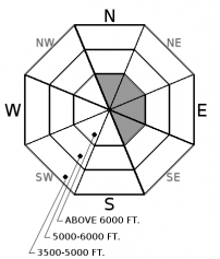
| Snow Line: |
Swan Range
How to read the forecast
New snow in the past 48 hours, combined with moderate southwesterly winds, have formed thin wind slabs at upper elevations which will thicken as the day progresses. A variety of weak layers exist in our pack which may be stressed by this new load or you and/or your machine. A human triggered avalanche is possible today and it is imperative to utilize safe travel techniques while evaluating snow and terrain carefully.

2. Moderate
?
Above 6500 ft.
2. Moderate
?
5000-6500 ft.
1. Low
?
3500-5000 ft.
- 1. Low
- 2. Moderate
- 3. Considerable
- 4. High
- 5. Extreme
-
Type ?
-
Aspect/Elevation ?

-
Likelihood ?CertainVery LikelyLikelyPossible
 Unlikely
 -
Size ?HistoricVery LargeLargeSmall

Over the past 48 hours weather stations are reporting up to 13" of snow with breezy west/southwest winds. This snow has fallen on a variety of surfaces including sun and rain crusts which may act as a slippery bed surface. At upper elevations expect to find isolated thin wind slabs on leeward terrain which will increase in thickness as the day progresses. This is a surface problem and is easily identified by hand pits and cracking in the surface snow under your skis or machine. Test small slopes before committing to larger terrain and use caution around convexities (rollovers), terrain traps and steep terrain below ridgelines or in gullies.
-
Type ?
-
Aspect/Elevation ?

-
Likelihood ?CertainVery LikelyLikelyPossible
 Unlikely
 -
Size ?HistoricVery LargeLargeSmall

The January 9 rain event created a new rain crust which may have faceted snow on top and/or below this layer forming our new persistent slab problem. This layer is buried 2-3' deep and recently found to be reactive in southern Glacier Park (see this observation). There have also been observations of a surface hoar layer, buried 2-3' deep, found to be reactive in parts of our area (see this observation). Both of these problems can be identified by a small amount of digging into the snow. These layers will be most susceptible to human triggering where the overlying slab is thinnest or associated with rock outcrops. Be alert for warning signs of instability such as shooting cracks and audible collapses. When in doubt, stick to lower angle slopes with less consequential terrain.
Precipitation in the past 24 hours was very light and favored the southern Whitefish Range along with the Flathead Range and southern Glacier Park: 8”/ 0.21” at Big Mountain, 2”/0.4” SWE at Pike Creek near Marias Pass, 3-4"/0.24" in the valley floor of John F. Stevens Canyon and 3-4" at Shed 7. At low/mid elevations, and some upper elevation locations, this snow is falling on a surface rain crust formed Thursday and/or a sun crust formed earlier in the week.
This seasons fluctuating weather patterns have left us with a variety of persistent slab/deep slab problems that can be a bit difficult to keep straight. The Thanksgiving/December 17 rain crust and associated weak faceted snow is found at the bottom of our pack and finally woke up last weekend producing very large and destructive avalanches in the Flathead and Whitefish Ranges. Due to the depth these layers are found below the surface, we now refer to these as our deep slab problem. On January 9 a warm wet system deposited a rain crust that extends to nearly 7000' in places with faceting around this crust creating our new persistent slab problem. How significant and widespread of a problem this layer remains to be seen. Yesterday, I found this layer 2' below the surface at 6300' in Rescue Creek and it wouldn't budge but the BNSF avalanche safety team reported propagating results in stability test on facets above the crust on Thursday. Human triggered persistent slab avalanche become more difficult as time passes after a major loading event and obvious signs of instability can be limited to non-existent. Persistent slabs have erratic/ unpredictable behavior and require digging to determine their existence and when stability is in question, terrain is the number one answer.
Despite low snowfall amounts, reactive storm slabs are possible at upper elevations, or in isolated wind-loaded slopes and gullies. Use small test slopes to evaluate new snow bonding to the newly formed rain crust before easing into steeper, more consequential terrain. Don’t let modest snowfall amounts introduce complacency into your decision making and always use safe travel techniques of only exposing one person to a slope and always carry rescue gear.
Scattered snow showers are on tap for today through tonight depositing light accumulations at mid and upper elevations with cooler weather keeping the snow level near the valley floor. Weak high pressure will build tomorrow before another round of precipitation enters our area Sunday night/Monday.
This advisory applies only to backcountry areas outside established ski area boundaries. This advisory describes general avalanche conditions and local variations always occur. This advisory expires at midnight on the posted day unless otherwise noted. The information in this advisory is provided by the USDA Forest Service who is solely responsible for its content.


