| Friday | Friday Night | Saturday | |
|---|---|---|---|
| Cloud Cover: | Light snow | Light snow | Snow ending by mid-day |
| Temperatures: | 25 to 30 deg. F. | 17 to 22 deg. F. | 25 to 30 deg. F. |
| Wind Direction: | SW | SW | W |
| Wind Speed: | 10 to 15 mph, gusting 20 mph | 5 to 10 mph, gusting 20 mph | 5 to 10 mph, gusting 20 mph |
| Snowfall: | 0 to 1 in. | 0 to 2 in. | 0 to 1 in. |
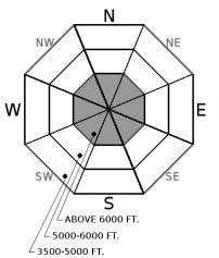
| Snow Line: |
Swan Range
How to read the forecast
Heightened avalanche conditions exist as snowfall continues to load buried weak layers that produced large and destructive avalanches earlier in the week. Natural or human triggered storm slabs will be likely on slopes steeper than 35 degrees at upper elevations. Diligent snowpack evaluation and cautious route-finding will be essential in managing our complex persistent slab problem, with generally safer conditions found at lower elevations.

2. Moderate
?
Above 6500 ft.
2. Moderate
?
5000-6500 ft.
1. Low
?
3500-5000 ft.
- 1. Low
- 2. Moderate
- 3. Considerable
- 4. High
- 5. Extreme
-
Type ?
-
Aspect/Elevation ?

-
Likelihood ?CertainVery LikelyLikelyPossible
 Unlikely
 -
Size ?HistoricVery LargeLargeSmall

Cohesive slabs 2-3' thick are found above the 1/9 rain crust at mid to upper elevations in the Swan Range. We haven't recieved any observations of human triggered or natural avalanches in the Swan Range since the major loading event last week. I traveled in the Swan Range yesterday and found a generally stable snowpack above the 1/9 rain crust. Although evidence of our persistent slab problem is not as obvious as other places in our forecast area, a poor snowpack structure lingers making it possible to trigger a persistent slab avalanche. Likely human trigger locations are where the slab is thinnest or near rock outcrops. Have a keen eye for bulls-eye warning signs of instability such as shooting cracks and audible collapses. This complex problem has slope to slope and basin to basin variability so assess each slope and identify weak layers before going “all in”. When in doubt, stick to lower angle slopes with less consequential terrain.
-
Type ?
-
Aspect/Elevation ?

-
Likelihood ?CertainVery LikelyLikelyPossible
 Unlikely
 -
Size ?HistoricVery LargeLargeSmall

At higher elevations, as much as 6 to 8" has accumulated. Human triggering of storm slabs remains possible today as you gain elevation with continued snowfall above a rain crust that formed at the beginning of the storm. Evaluate storm totals, wind loading, and test small slopes before easing into bigger, steeper terrain. Watch for cracking in the new snow and avoid lens shaped pillows that could be more reactive from the weight of a skier or rider. These slides are expected to be small, but may be larger on the most wind loaded slopes, so use caution around terrain traps, steep rollovers, and leeward features and gullies.
Weather stations throughout our forecast area are reporting light snowfall over the past 24 hours: 3”/ 0.3” SWE at Big Mountain, 8"/ 1.1” SWE at Stahl Peak in the northern Whitefish Range, 1”/0.4” SWE at Noisy Basin, 2”/0.8” SWE at Pike Creek in eastern Flathead, and 8"/1.2” SWE at Flattop in GNP. Our current storm system came in warm with freezing rain up to 7000’ in the Swan Range and up to 5500’ in the John F. Stevens Canyon. Yesterday’s rain on snow event didn’t add a lot of water to our snowpack, but combined with additional snowfall adds more stress to buried weak layers consisting of surface hoar and faceted rain crust on some slopes.
Very large and destructive avalanches were observed in the Flathead and Whitefish Ranges over the past week providing us with a clear and in-your-face reminder that a poor snowpack structure lingers and is capable of producing avalanches. Yesterday, professional observers in the John F. Stevens Canyon reported propagating results in stability test on facets above our 1/9 rain crust. Human triggered persistent slab avalanche become more difficult as time passes after a major loading event and obvious signs of instability can be limited to non-existent. Persistent slabs have erratic/ unpredictable behavior and require digging to determine their existence and when stability is in question, terrain is the number one answer.
Despite low snowfall amounts, reactive storm slabs are possible at upper elevations, or in isolated wind-loaded slopes and gullies. Use small test slopes to evaluate new snow bonding to the newly formed rain crust before easing into steeper, more consequential terrain. Don’t let modest snowfall amounts introduce complacency into your decision making and always use safe travel techniques of only exposing one person to a slope and always carry rescue gear.
Cold front moved through northwest Montana yesterday ushering in cooler air and lowering snow levels to valley floors. Currently, southwest flow and light precipitation is being observed over the Idaho panhandle and northwest Montana. Cool and showery conditions will persist over northwest Montana today and into Saturday. Light accumulations can be expected during this time frame and a weak high pressure builds over the area on Sunday for drier conditions. We can anticipate 3-7" of snow and 0.5" SWE by the end of day Saturday.
This advisory applies only to backcountry areas outside established ski area boundaries. This advisory describes general avalanche conditions and local variations always occur. This advisory expires at midnight on the posted day unless otherwise noted. The information in this advisory is provided by the USDA Forest Service who is solely responsible for its content.


