| Thursday | Thursday Night | Friday | |
|---|---|---|---|
| Cloud Cover: | Snow and freezing rain | Snow | Snow becoming light by afternoon |
| Temperatures: | 32 to 38 deg. F. | 20 to 25 deg. F. | 25 to 30 deg. F. |
| Wind Direction: | SW | SW | SW to W |
| Wind Speed: | 15 to 20 mph, gusting to 40 mph | 10 to 15 mph, gusting to 35 mph | 10 to 15 mph, gusting to 20 mph |
| Snowfall: | 1 to 3 in. | 3 to 5 in. | 1 to 2 in. |
| Snow Line: |
Whitefish Range
Flathead Range and Glacier National Park
How to read the forecast
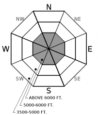
Warm temperatures, rain, wind, and dense snow will create increasingly dangerous avalanche conditions today. These ingredients are all stressing buried weak layers, which have been producing very large and destructive avalanches in the past week. Storm instabilities and loose wet avalanches will become more reactive to human or natrual triggers through the day. Careful snowpack evaluation and cautious route-finding are essential with our complex snowpack.

3. Considerable
?
Above 6500 ft.
3. Considerable
?
5000-6500 ft.
2. Moderate
?
3500-5000 ft.
- 1. Low
- 2. Moderate
- 3. Considerable
- 4. High
- 5. Extreme
-
Type ?
-
Aspect/Elevation ?

-
Likelihood ?CertainVery LikelyLikelyPossible
 Unlikely
 -
Size ?HistoricVery LargeLargeSmall

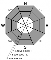
A number of deep slab and persistent slab avalanches ran during our last loading event. Another round of rain and dense snow will continue to stress recently buried surface hoar and faceted rain crust as well as weak layers near the ground. These unpredictable slabs are more likely to be sensitive to human or natural triggers today. Be on the watch out for shooting cracks and audible collapses which are bulls-eye warning signs of instability, but assess each slope to identify weak layers. If in doubt, stick to lower angle slopes with less consequential terrain, and give suspect alpine terrain a wide buffer, including runouts.
-
Type ?
-
Aspect/Elevation ?

-
Likelihood ?CertainVery LikelyLikelyPossible
 Unlikely
 -
Size ?HistoricVery LargeLargeSmall

Snow and strong winds will increase the sensitivity of fresh storm slabs, and these slabs will become larger and more reactive to human or natural triggers as snow accumulates and drifts. Anticipate widespread distribution at upper elevations, and thicker slabs on leeward slopes. Evaluate the size and sensitivity of storm slabs on small slopes before easing into bigger, steeper terrain. Surface cracking in new snow are signs of instability. Be cautious near terrain traps, steep rollovers, and wind loaded slopes.
-
Type ?
-
Aspect/Elevation ?

-
Likelihood ?CertainVery LikelyLikelyPossible
 Unlikely
 -
Size ?HistoricVery LargeLargeSmall

Above freezing temperatues and rain on snow will wet the surface snow making loose wet avalanches likely on steep slopes in lower to mid elevations, especially where the snow surface is loose and dry on shady aspects. Theses slides are generally small and slow moving, but could be large enough to bury you in a terrain trap or long running terrain. The rain line and associated wet avalanche activity is forecasted to be below 6,000' but monitor the weather in your travels to account for uncertainty. Rollerballs and pinwheels are indicators of surface snow instabilities.
Over the past week, very large and destructive avalanches were observed in the Flathead and Whitefish ranges. This is a clear and in-your-face reminder that our poor snowpack structure remains and is having a difficult time supporting significant loading events. Two prominent weak interfaces exist in our snowpack and are capable of producing deadly avalanches.
One is the December 15th/ Thanksgiving crust found near the bottom of our snowpack under a 3' to 6’+ hard slab. Last week’s rapid loading event reactivated this lurking layer and produced very large, deep slab avalanches on a few slopes that you would not survive. Triggering these deep monsters is most likely where the snowpack is shallow (video), on high elevation slopes with snow depth variability, or near rock outcrops. With today's warm and wet loading event, I would steer clear of that type of terrain, including the runout zones. Our second weak interface is found in the upper portion of our snowpack and consists of buried surface hoar and faceted rain crust. The surface hoar layer has not been found on all slopes but observed near Skyland, in the Middle Fork, and Whitefish Range. The rain crust is more widespread and Zach observed propagating results on this layer in the Flathead Range on Monday. Persistent slabs have erratic/ unpredictable behavior and require digging to determine their existence and when stability is in question, terrain is always the answer.
Our current storm system will consist of rain at lower elevations, dense snow, and strong winds at upper and mid elevations. Anticipate a changing snowpack as you move up and down in elevation and be diligent in your snowpack evaluations while use cautious route-finding. This is not the day to “step out” in newer terrain and always expect the unexpected during times of wild weather and unpredictable weak layers.
A warm and moist weather system will bring widespread precipitation to northwest Montana today into tonight. At 4 am, a cold front is currently aligned north to south in western Washington with an associated Low pressure system off the BC coast. Currently, southwest flow aloft this morning is pushing light precipitation into the Idaho panhandle and northwest Montana. Snow levels will start out between 5000' - 6000' but drop rapidly to valley bottoms with arrival of cold front this afternoon. Precipitation rates will increase with arrival of cold front and winds will be moderate to strong today and overnight with gusts exceeding 40 mph. Snowfall decreases during the day on Friday with light precipitation and west flow over the weekend. We can expect 8-12" of snow with 1-1.5" SWE by Friday evening.
This advisory applies only to backcountry areas outside established ski area boundaries. This advisory describes general avalanche conditions and local variations always occur. This advisory expires at midnight on the posted day unless otherwise noted. The information in this advisory is provided by the USDA Forest Service who is solely responsible for its content.


