| Saturday | Saturday Night | Sunday | |
|---|---|---|---|
| Cloud Cover: | Light snowfall and breezy | Clearing | Drying and warming |
| Temperatures: | 29 to 34 deg. F. | 23 to 28 deg. F. | 30 to 35 deg. F. |
| Wind Direction: | SW | SW | W |
| Wind Speed: | 6 to 16 mph with gusts to 40 | 1 to 11 mph | 1 to 11 mph |
| Snowfall: | 1 to 3 in. | 0 in. | 0 in. |
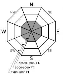
| Snow Line: |
Whitefish Range
Flathead Range and Glacier National Park
How to read the forecast
Elevated avalanche conditions remain as dense snowfall overnight and today, accompanied by light to moderate winds, is deposited on lower density surface snow. A human triggered storm slab is possible on slopes steeper than 35 degrees at upper elevations. In areas that harbor a shallow snowpack It remains possible to trigger a very large avalanche on buried weak layers. Evaluate the snow structure before committing to a slope and continue to practice safe travel techniques.

2. Moderate
?
Above 6500 ft.
2. Moderate
?
5000-6500 ft.
1. Low
?
3500-5000 ft.
- 1. Low
- 2. Moderate
- 3. Considerable
- 4. High
- 5. Extreme
-
Type ?
-
Aspect/Elevation ?

-
Likelihood ?CertainVery LikelyLikelyPossible
 Unlikely
 -
Size ?HistoricVery LargeLargeSmall

Weather stations from around the area are reporting roughly 0.5" of SWE in the past 24 hours, with most of this arriving in a 10 hour window overnight. This relatively warm dense snow is being deposited on top of low density surface snow resulting in an "upside down" surface snowpack structure. In some locations this surface snow is resting on a rain crust which could act as a slippery bed surface. Light to moderate winds overnight and through the day will redistribute this snow into thicker slabs at upper elevation leeward locations. Human triggered storm slabs remains possible today. This is a snow surface problem and identifiable by cracking or collapsing under your feet or machine with hand pits identifying this snow structure. Test small inconsequential slopes before committing to larger steeper terrain and continue to use caution around terrain traps, steep rollovers, or in isolated wind-loaded slopes or gullies.
-
Type ?
-
Aspect/Elevation ?

-
Likelihood ?CertainVery LikelyLikelyPossible
 Unlikely
 -
Size ?HistoricVery LargeLargeSmall

Areas that maintain a thin snowpack of less than 4' depth are most susceptible to human triggering due to the poor snowpack structure consisting of facets and crust(s).This weeks storm cycle has stressed the weak layers buried near the bottom of our pack and they may be more reactive to the weight of a rider or their machine. On Thursday, in the thin snowpack of the northern Whitefish Range, Zach reported a large rumbling collapse on facets near the ground. This is an obvious sign of instability as are more subtle collapses or shooting cracks. In areas where a weak snow structure exists it is best to default to lower angle terrain and avoid convex rollovers.
The storm cycle that we enjoyed this week is winding down with some impressive Snow Water Equivalent (SWE) amounts: Noisy Basin 5.4", Flattop 3.4", Stahl 2.8", Pike Creek 2.1" and Emery Creek 1.5". This precipitation arrived warm and wet with rain recorded up to 6000' (or higher) on Tuesday, followed by cooler low density snow Wednesday - Friday and ending with relatively warm dense snow overnight. These waves of energy stressed the surface snowpack along with deeply buried weak layers resulting in elevated avalanche danger.
The "big picture" good news is that we continue to strengthen our snowpack structure due to warming and increasing the depth of our pack. We have dropped the Deep Slab problem from the Swan Range due to the strengthening of the facet layer and the unlikelihood of triggering (see this observation). The Persistent Slab problem remains in areas that still possess a thin snowpack such as the eastern Flathead Range (east of Essex), southern Glacier Park (John F. Stevens Canyon east to Marias Pass) and the northern Whitefish Range. As long as a poor snowpack structure lingers, it is still possible to trigger a very large destructive avalanche. Zach found this poor structure in the northern Whitefish Range Thursday where snow depths are the shallowest in our advisory area (see this observation). Slopes with depths less than 4’ should be treated as suspect and given a wide buffer around steeper terrain. Remember that persistent slabs can be triggered from below or on adjacent slopes. Be diligent with snowpack evaluations, practice cautious route-finding, and conservative decision-making is essential when managing the uncertainty around this problem.
The last of this weeks waves of energy is moving through our area today. Light snow will taper through the day with light southwest winds accompanied by moderate to strong gusts. A ridge of high pressure will build overnight leading to a brief gradual clearing and warming trend Sunday and Monday with moisture on tap to return Tuesday.
This advisory applies only to backcountry areas outside established ski area boundaries. This advisory describes general avalanche conditions and local variations always occur. This advisory expires at midnight on the posted day unless otherwise noted. The information in this advisory is provided by the USDA Forest Service who is solely responsible for its content.


