| Tuesday | Tuesday Night | Wednesday | |
|---|---|---|---|
| Cloud Cover: | Mix of rain and snow | Snow levels lowering | Steady snowfall |
| Temperatures: | 32 to 37 deg. F. | 18 to 23 deg. F. | 20 to 25 deg. F. |
| Wind Direction: | SW | W | W |
| Wind Speed: | 10 to 20, gusting to 30 | 5 to 15, gusting to 25 | 0 to 10 |
| Snowfall: | 1 to 4 in. | 5 to 9 Swan, 3 to 5 elsewhere in. | 6 to 8 Swan, 3 to 6 elsewhere in. |
| Snow Line: |
Whitefish Range
Flathead Range and Glacier National Park
How to read the forecast
A warm and wet system will increase the avalanche danger today and tonight. The danger is Moderate this morning and will rise to Considerable by this afternoon as new snow and gusty winds create sensitive storm instabilities. Problematic weak layers still lurk deeper in the snowpack, complicating today's travel advice. Default towards conservative terrain choices as conditions change through the day.

3. Considerable
?
Above 6500 ft.
2. Moderate
?
5000-6500 ft.
2. Moderate
?
3500-5000 ft.
- 1. Low
- 2. Moderate
- 3. Considerable
- 4. High
- 5. Extreme
-
Type ?
-
Aspect/Elevation ?

-
Likelihood ?CertainVery LikelyLikelyPossible
 Unlikely
 -
Size ?HistoricVery LargeLargeSmall

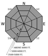
As much as 8" of dense new snow today, accompanied by gusty southwest winds, will create sensitive storm slab instabilities at mid and upper elevations. These will grow in size through the day and overnight, overloading recently buried weak layers and crusts. Windloaded slopes will be the most problematic, but slabs will become more widespread across all terrain features as snow totals increase. Watch for changing conditions by monitoring snowfall rates, looking for cracking, and avoiding windloaded slopes.
-
Type ?
-
Aspect/Elevation ?

-
Likelihood ?CertainVery LikelyLikelyPossible
 Unlikely
 -
Size ?HistoricVery LargeLargeSmall

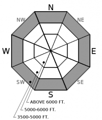
Dense persistent slabs remain a concern on some slopes. Additional loading will continue to stress the facets or faceted crusts that are now 2 to 3 feet deep in the Whitefish and Flathead Range. These weak layers have been most reactive in areas where the snow depth is shallower (generally less than 4 feet deep). This video is a great example of the problem. The best way to handle the potential for triggering a large and destructive avalanche problem is conservative terrain choices. Default to simpler terrain and avoid steep rollovers if you have uncertainty about the snowpack structure.
-
Type ?
-
Aspect/Elevation ?

-
Likelihood ?CertainVery LikelyLikelyPossible
 Unlikely
 -
Size ?HistoricVery LargeLargeSmall

Rain at lower elevations has potential to destabilize the snow surface in steep slopes and gullies. Watch for rain on snow, rollerballs, and small wet avalanches to indicate changing conditions. Avoid traveling in terrain traps if you identify unstable wet snow.
The timing and intensity of today's storm will dictate how widespread and reactive storm instabilities become. I expect to see some natural avalanche activity by this afternoon or tonight as our recent dry spell layers and crusts get their first rapid load. Yesterday, observers in the Flathead Range noted a recently buried crust, about 10" or 15" deep, was becoming reactive in stability tests. In the Whitefish Range, we found reactive weak layers near the surface a few days ago. Dense snow and gusty winds will be loading up these layers through the day and overnight. We're looking at roughly 6" of snow by this afternoon, and at least a foot tonight and tomorrow. Soft slabs up to several feet thick will be easily triggered and could fail naturally later today or overnight, especially on high elevation, wind loaded slopes. The freezing level will be around 5,000 feet in the Swan and Flathead Ranges, and 4,000 feet in the Whitefish Range. Below the snow line, watch for the potential for wet loose avalanches.
The persistent slab structure has been fairly quiet over the last week. Our last human triggered avalanche was last Monday, and reports of collapses started to wane mid-week. However, we continue to find unnerving structures on some slopes, with weak layers that propagate failures in our stability tests (example A, example B). The common theme for these reactive stability tests has been areas with a shallower and weaker snowpack. In general, these shallower areas are more common in the Eastern Flathead and Northern Whitefish Range, but this problem is highly variable. With another loading event on tap for the rest of the week, allow for a margin of error in your stability assessments for this larger and less predictable problem.
A Pacific trough moving across Southern California will steer warm moisture into the Northwest today. Look for around 0.75" of precipitation to fall by this evening in the form of relatively dense snow above 5000 feet and a mix of rain and snow below. Snowfall continues through the night with freezing levels dropping to the valley floor by tomorrow morning. The Swan Range is favored with nearly 2 feet of snow forecasted by Wednesday night. Gusty southwest winds accompany this system, but let up by tomorrow. Another big snow producer shows up on Thursday and Friday.
This advisory applies only to backcountry areas outside established ski area boundaries. This advisory describes general avalanche conditions and local variations always occur. This advisory expires at midnight on the posted day unless otherwise noted. The information in this advisory is provided by the USDA Forest Service who is solely responsible for its content.


