| Monday | Monday Night | Tuesday | |
|---|---|---|---|
| Cloud Cover: | Light precip. | Light precip. | Snow increasing during the day. |
| Temperatures: | 33 to 38 deg. F. | 23 to 28 deg. F. | 30 to 35 deg. F. |
| Wind Direction: | SW | SW | SW |
| Wind Speed: | 5 to 10 mph | 0 to 5 mph | 10 to 15 mph with gusts of 20 mph |
| Snowfall: | 0 in. | 0 in. | 1 to 3 in. |
| Snow Line: |
Whitefish Range
Flathead Range and Glacier National Park
How to read the forecast
Light snowfall combined with warm temperatures is consolidating the snowpack into a more cohesive slab overlying a poor snowpack structure that remains susceptible to human triggering. This could result in large or destructive avalanche. Thin wind slabs have formed on leeward slopes at upper elevations from recent snow and southwest winds. Stay alert for obvious signs of instability such as cracking and collapsing, evaluate the snowpack before committing to steeper terrain, and continue practicing safe travel techniques.

2. Moderate
?
Above 6500 ft.
2. Moderate
?
5000-6500 ft.
2. Moderate
?
3500-5000 ft.
- 1. Low
- 2. Moderate
- 3. Considerable
- 4. High
- 5. Extreme
-
Type ?
-
Aspect/Elevation ?

-
Likelihood ?CertainVery LikelyLikelyPossible
 Unlikely
 -
Size ?HistoricVery LargeLargeSmall

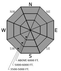
Over the past 72 hours, light snowfall (up to 1-1.5" SWE) combined with warmer temperatures has warmed the snowpack at all elevations and is making the snowpack denser and more cohesive. Observations confirm that weak, faceted snow below a 2-4’ slab exists in many locations in the Whitefish Range, Flathead Range, and southern Glacier National Park, although signs of instability have decreased. As long as our poor snowpack structure lingers, it remains possible to trigger a dangerous persistent slab avalanche. The best chance for a skier or rider to trigger a large and destructive slide is from shallow or thin places on a slope. Our persistent slab problem is spatially variable and digging is the best way to identify or test for a poor structure. Treat every slope as if it could slide and when in doubt, default to lower angle terrain free of convexities (rollovers), terrain traps, or cliffs to manage this problem.
-
Type ?
-
Aspect/Elevation ?

-
Likelihood ?CertainVery LikelyLikelyPossible
 Unlikely
 -
Size ?HistoricVery LargeLargeSmall

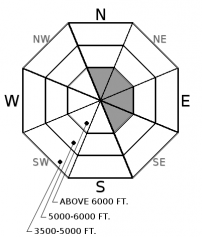
Snowfall combined with light to moderate southwest winds over the weekend have formed wind slabs on a variety of old snow surfaces including recently formed surface facets, freezing rain crust, and sun crusts on southerly aspects. Anticipate finding these thin slabs on leeward sides of ridges and cross-loaded terrain features and evaluate the snow surface before committing to larger, wind-loaded slopes. Look for signs of recently drifting snow and watch for cracking underneather your skis or machine to identify the problem.
Don’t you wish that fresh snow would just bury our avalanche problems and make them disappear? Unfortunately, that is not the case nor are we that lucky. Dribs and drabs of snowfall over the last 72 hours (1.1 SWE in Whitefish Range, 0.5 SWE in Flathead Range, and 1.5 SWE in southern Glacier National Park) has not “tipped the scales”, but combined with warmer temps is helping the snowpack gradually consolidate into a more cohesive slab. New snowfall is now sitting on top of a recently faceted snow surface, freezing rain crust, and sun crust on southerly aspects. With continued light snowfall and southwest winds, evaluate new snow bonding in both wind-loaded and wind-sheltered terrain and stay heads up for obvious signs of instability such as cracking and collapsing.
As long as our poor snowpack structure lingers (observation), it’s still possible to trigger a dangerous persistent slab avalanche. Managing the uncertainty is the greatest challenge of a persistent slab problem. The only way to manage this uncertainty is to recognize where triggering a persistent slab avalanche is more likely and making conservative terrain selections. These are typically found on steep slopes, slopes with wind effect or stiffer slabs from wind-deposited snow, and unsupported slopes with convexities. During times like this, it’s best to treat every slope as if it could slide and carefully evaluate the snowpack. My snow and avalanche mentor once said, if stability is the question, terrain is the answer.
The avalanche fatality in Southwest Montana (video) and the recent avalanche outside of Fernie, BC that injured several skiers (article) is a good reminder of how unpredictable our current snowpack is.
Light precipitation will continue today over northwest Montana with a better chance at accumulating snow on Tuesday. A Low pressure system and cold front is positioned off the Washington coast and will move over the area today while a ridge of High pressure passes to our south. By tomorrow, a deep trough develops over the southwestern US and will pump warm, moisture air into northwest Montana. Snow levels over the next 24 to 48 hours will fluctuate between 3000-4000 feet and we can expect 3-5" of snow by Tuesday afternoon.
This advisory applies only to backcountry areas outside established ski area boundaries. This advisory describes general avalanche conditions and local variations always occur. This advisory expires at midnight on the posted day unless otherwise noted. The information in this advisory is provided by the USDA Forest Service who is solely responsible for its content.


