| Saturday | Saturday Night | Sunday | |
|---|---|---|---|
| Cloud Cover: | Areas of freezing rain this morning transitioning to a rain/snow mix | Light snow and breezy conditions | Light snow |
| Temperatures: | 30 to 35 deg. F. | 21 to 26 deg. F. | 27 to 32 deg. F. |
| Wind Direction: | Southwest | Southwest | Southwest |
| Wind Speed: | 5 to 15 with gusts to 30 | 1 to 11 with gusts to 23 in the Flathead Range | 1 to 11with gusts to 25 in the Flathead and Swan Ranges |
| Snowfall: | 2 to 4 in. | 1 to 2 in. | 0 to 2 in. |
| Snow Line: |
Whitefish Range
Flathead Range and Glacier National Park
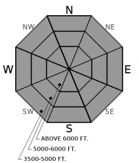
How to read the forecast
The current warming and changing conditions may stress areas where our snowpack structure remains weak and a human triggered slide could result in a very large destructive avalanche. The surface slab is consolidating with these warm conditions and it is imperative to recognize obvious signs of instability such as cracking and collapsing beneath your feet or machine while practicing safe travel techniques such as one member of the party on a slope at a time.

2. Moderate
?
Above 6500 ft.
2. Moderate
?
5000-6500 ft.
2. Moderate
?
3500-5000 ft.
- 1. Low
- 2. Moderate
- 3. Considerable
- 4. High
- 5. Extreme
-
Type ?
-
Aspect/Elevation ?

-
Likelihood ?CertainVery LikelyLikelyPossible
 Unlikely
 -
Size ?HistoricVery LargeLargeSmall

The current storm is warming the snowpack at all elevations and it is uncertain how our Persistent Slab problem will react to these changing conditions. This warmup will consolidate the 2-4' thick slab that is overlying a weak faceted layer that exists in some locations. Due to the warming this slab may become more reactive to the weight of a rider or their machine and may produce audible collapses and/or a large destructive slide. Our persistent slab problem is not found on all slopes or aspects and requires digging to identify. Once identified it is best to default to lower angle terrain, well anchored terrain and areas free of convexities (rollovers).
After a week of dry conditions, light precipitation entered our area last night depositing warm moist snow at upper elevations with a wintry mix at lower elevations. This new snow is falling on a variety of surfaces including sun crusts on sunny aspects and weak faceted snow in sheltered locations. Accompanying this system are light to moderate westerly winds with strong gusts. The Hornet weather station in the northern Whitefish Range reported sustained winds of 26 mph with gusts to 36 this morning. The combination of warm moist snow and wind will form thin storm slabs as the day progresses, with these slabs thicker in leeward locations. Look for obvious surface clues such as cracking or collapsing in areas of deeper accumulation.
At mid and lower elevations a rain/snow mix will add weight to locations where the surface is comprised of dry loose snow. Rollerballs/pinwheels are an indicator that the surface snow is becoming unstable. Associated loose slides will be small but could be troublesome if you are above a terrain trap or cliff band.
The persistent slab problem is not something we deal with on an annual basis in Northwest Montana and complacency to this problem is something we all need to fight. The partial burial of a snowmobiler in the usually strong snowpack of the Whitefish Range should be a good wake up call to all (see observation). There were two avalanche fatalities this week from northern Wyoming (article) and Southwestern Montana (article) where this is a more common problem.
A warm pacific disturbance moved into our area resulting in high freezing levels and windy conditions. Cold pools of air in valley locations has resulted in areas of freezing rain and light rain where these cold pools have been scoured out. Ridgetop locations have remained all snow with light accumulations. A cold front will arrive later this morning lowering snow levels but increasing ridgetop winds. This weak storm will move out of our area by tomorrow and replaced by a short window of dry weather.
This advisory applies only to backcountry areas outside established ski area boundaries. This advisory describes general avalanche conditions and local variations always occur. This advisory expires at midnight on the posted day unless otherwise noted. The information in this advisory is provided by the USDA Forest Service who is solely responsible for its content.


