| Friday | Friday Night | Saturday | |
|---|---|---|---|
| Cloud Cover: | Valley temperature inversion with possible freezing rain. | Valley temperature inversion with possible freezing rain. | Wintry mix |
| Temperatures: | 27 to 32 deg. F. | 24 to 29 deg. F. | 29 to 34 deg. F. |
| Wind Direction: | Southwest | Southwest | Southwest |
| Wind Speed: | 1 to 11 | 1 to 11 with gusts to 23 in the Flathead Range | 5-15 with gusts to 25 in the Flathead and Swan Ranges |
| Snowfall: | 0 in. | 0 to 1 in. | 0 to 2 in. |
| Snow Line: |
Swan Range
How to read the forecast
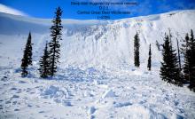
Nearly a week without substantial new snow has resulted in avalanches becoming more difficult to trigger. However, a poor snowpack structure remains in locations where a human triggered slide could result in a very large destructive avalanche. Continue to recognize obvious signs of instability such as cracking and collapsing beneath your feet or machine while practicing safe travel techniques such as one member of the party on a slope at a time.

2. Moderate
?
Above 6500 ft.
2. Moderate
?
5000-6500 ft.
1. Low
?
3500-5000 ft.
- 1. Low
- 2. Moderate
- 3. Considerable
- 4. High
- 5. Extreme
-
Type ?
-
Aspect/Elevation ?

-
Likelihood ?CertainVery LikelyLikelyPossible
 Unlikely
 -
Size ?HistoricVery LargeLargeSmall

The Swan Range received the lions share of our last storm which has resulted in a 4 to 5 foot thick surface slab of snow. In some locations a weak layer(s) of faceted snow is buried beneath this slab resulting in a poor snowpack structure at mid and upper elevations and isolated lower elevation locations. Where this slab is thinner it will be more reactive to the weight of a rider or their machine and may produce audible collapses and/or a large destructive slide. Our persistent slab problem is not found on all slopes or aspects and requires digging to identify. Once identified it is best to default to lower angle terrain, well anchored terrain and areas free of convexities (rollovers). Safe travel techniques with just one member of the party on a questionable slope is imperative to minimize the stress on this weak layer.
Our recent drying trend has allowed the surface snowpack to gain strength allowing us to remove surface instabilities from our list of problems. Great, one less problem to deal with! As time elapses we are also noticing less bulls eye data associated with our persistent slab problem. Great...sort of. Without the obvious red flags of recent avalanche activity, whumpfing or collapsing of the buried weak layer(s) and cracking in the surface snow it is easy to forget about what is under your feet or machine, especially when combined with the recent bluebird skies we have enjoyed above the inversion. The persistent slab problem is not something we deal with on an annual basis in Northwest Montana and complacency to this problem is something we all need to fight. The partial burial of a snowmobiler in the usually strong snowpack of the Whitefish Range should be a good wake up call to all (see observation). There were two avalanche fatalities this week from northern Wyoming (article) and Southwestern Montana (article) where this is a more common problem. Think of it as a good year for us to work on improving our safe travel techniques, terrain recognition and snowpack assessments. Some years are snowpack is a big wall of white with no obvious discerning layers but this is a great year to dig and identify the obvious weak layer(s) in the pack.
The high pressure ridge has broken down as weak pacific moisture moves into our area. Valley temperature inversions remain with a layer of warm air aloft resulting in warm cloudy conditions at ridgetop locations. Precipitation will increase tonight into tomorrow but remain light with the most significant impact being potential freezing rain in valley locations. A cold front arrives tomorrow with associated lowering freezing levels. Light precipitation continues through Sunday morning.
This advisory applies only to backcountry areas outside established ski area boundaries. This advisory describes general avalanche conditions and local variations always occur. This advisory expires at midnight on the posted day unless otherwise noted. The information in this advisory is provided by the USDA Forest Service who is solely responsible for its content.


