| Sunday | Sunday Night | Monday | |
|---|---|---|---|
| Cloud Cover: | Partly cloudy and dry with light winds. | Continued drying with light winds. | Partly sunny and warming. |
| Temperatures: | 12 to 17 deg. F. | 0 to 5 deg. F. | 15 to 20 deg. F. |
| Wind Direction: | West | Southwest | Southwest |
| Wind Speed: | 0 to 10 mph | 0 to 10 mph | 0 to 10 mph |
| Snowfall: | 0 in. | 0 in. | 0 in. |
| Snow Line: |
Whitefish Range
Swan Range
Flathead Range and Glacier National Park
How to read the forecast
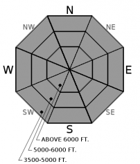
The recent bountiful storm is over but dangerous avalanche conditions remain. The avalanche danger is CONSIDERABLE on all aspects and elevations. The natural avalanche cycle has ended but triggering a storm slab avalanche is LIKELY today. Persistent slab avalanches have the potential to be very large and destructive. Cautious routefinding and conservative decision making are essential.

3. Considerable
?
Above 6500 ft.
3. Considerable
?
5000-6500 ft.
3. Considerable
?
3500-5000 ft.
- 1. Low
- 2. Moderate
- 3. Considerable
- 4. High
- 5. Extreme
-
Type ?
-
Aspect/Elevation ?

-
Likelihood ?CertainVery LikelyLikelyPossible
 Unlikely
 -
Size ?HistoricVery LargeLargeSmall

Numerous natural and human triggered storm slab avalanches have been observed at all elevations over the past 48 hours (see observation). These avalanches were the result of recent relatively warm dense snow deposited on top of low density snow that fell earlier in the week. Gusty winds have redistributed this snow forming thicker slabs, especially in the eastern portion of our area, while larger slabs will also be found in areas favored by recent snowfall such as the Swan Range. The natural storm slab cycle is over but a human triggered slide is LIKELY today. Look for cracking, recent avalanches, and ease into small, inconsequential terrain to manage this problem.
-
Type ?
-
Aspect/Elevation ?

-
Likelihood ?CertainVery LikelyLikelyPossible
 Unlikely
 -
Size ?HistoricVery LargeLargeSmall

Our recent storm added substantial weight to areas that harbor a weak snowpack structure. In some locations the weak faceted snow failed resulting in an avalanche, while other areas are requiring an additional load to tip the balance. This weak snow has been well documented and can be found buried under persistent slabs 3 to 6 feet thick (see observation). The natural avalanche cycle has ended but a human triggered persistent slab is POSSIBLE with resulting avalanches large and dangerous. Collapses and whumphs are an obvious sign of instability (like this observation), but digging into the snow is the only way to know if this snow structure exists; reducing your exposure to avalanche terrain is the easiest and safest way to deal with this problem.
The recent bountiful storm ended yesterday depositing 0.2 - 0.4" of water in the past 24 hours with impressive storm totals of 2.0 - 4.7" of SWE across our area. This translates into roughly 2 - 5' of new snow with exact numbers unknown in most locations due to settlement. Traveling in this new snow is arduous at best and therefore observations from the field have been limited but we observed a natural storm slab avalanche cycle on both Friday and Saturday in the southern Whitefish Range (observation 1, observation 2). The natural storm slab cycle has ended but these recently formed slabs are LIKELY to be human triggered today at all elevations and on all aspects.
The storm slab problem is confined to the near surface and therefore will be a relatively short lived problem. Unfortunately that is not the case with our persistent slab problem where a poor snowpack structure with weak, faceted snow is now buried 3 to 6 feet deep. On some slopes these weak layers were flushed away during the avalanche cycles that ended 12/20 and 12/30 while on other slopes there is a relatively strong snow structure (observation). Yesterday, observers near Mt. Werner experienced widespread collapsing on this buried layer - a sure sign of a reactive snowpack. In the absence of these red flags, digging into the snow is the only way to identify this problem. We believe the large magnitude slide which snapped numerous trees and reached the rail grade yesterday morning in John F. Stevens Canyon may have been a persistent slab avalanche. Choosing less consequential terrain is the easiest and safest way to manage this complex problem.
Recent moderate to strong winds easterly winds transported substantial snow in the eastern portion of our area. The BNSF snow safety team observed blizzard conditions with accompanying wind slab formation at valley floor locations Saturday. Shooting cracks, whumpfing and skier triggered wind slabs were noted.
The Flathead Avalanche Center presents two engaging and free one-hour Avalanche Awareness talks this week. Join us at at Stumptown Snowboards in Whitefish on Wednesday, January 3, from 7 PM - 8 PM ro Stonefly Lounge in Coram on Thursday, January 4, from 7 PM - 8 PM. The class includes general information about avalanche hazard, how to avoid it, and proper equipment for traveling in avalanche terrain. . Contact [email protected] with any questions.
Precipitation associated with our recent storm wound down yesterday afternoon and moved out of our area. Arctic air will retreat east towards the Continental Divide as high pressure builds to our west. Mid and upper elevation locations will warm today with cold air pooling in the valleys. Dry conditions with calm winds can be expected today and over the next few days.
This advisory applies only to backcountry areas outside established ski area boundaries. This advisory describes general avalanche conditions and local variations always occur. This advisory expires at midnight on the posted day unless otherwise noted. The information in this advisory is provided by the USDA Forest Service who is solely responsible for its content.


