| Saturday | Saturday Night | Sunday | |
|---|---|---|---|
| Cloud Cover: | Snow tapering with breezy conditions. | Clearing | Partly cloudy and warming. |
| Temperatures: | 10 to 15 deg. F. | -5 to 0 deg. F. | 11 to 16 deg. F. |
| Wind Direction: | North | Northwest | Southwest |
| Wind Speed: | 5 to 10 mph with gusts of 25 mph | 0 to 10 mph | 0 to 10 mph |
| Snowfall: | 3 to 6 in. | 0-2 in. | 0 in. |
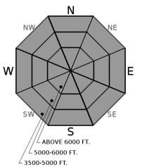
| Snow Line: |
Swan Range
Flathead Range and Glacier National Park
How to read the forecast
An AVALANCHE WARNING remains in effect until 5 p.m. Continued snowfall, accompanied by shifting winds, has created very dangerous avalanche conditions. The avalanche danger is HIGH on all aspects above 5000 feet. A natural avalanche cycle is ongoing and triggering a dangerous avalanche is VERY LIKELY today. Persistent slab avalanches have the potential to be very large and destructive. Travel in avalanche terrain is not recommended.

4. High
?
Above 6500 ft.
4. High
?
5000-6500 ft.
3. Considerable
?
3500-5000 ft.
- 1. Low
- 2. Moderate
- 3. Considerable
- 4. High
- 5. Extreme
-
Type ?
-
Aspect/Elevation ?

-
Likelihood ?CertainVery LikelyLikelyPossible
 Unlikely
 -
Size ?HistoricVery LargeLargeSmall

Our current storm arrived relatively warm and initially deposited denser snow on top of low density snow that fell earlier in the week. This near surface "upside down" snow structure has resulted in storm slabs that will fail naturally (see observation) or will be easily human triggered (see video). Winds from the north and east have redistributed snow onto atypical aspects forming thicker slabs on these leeward features. Current winds have shifted to the west and are beginning to load typical leeward aspects. Today's storm slabs will be large enough to bury or kill you and traveling on or below steep avalanche terrain is not recommended.
-
Type ?
-
Aspect/Elevation ?

-
Likelihood ?CertainVery LikelyLikelyPossible
 Unlikely
 -
Size ?HistoricVery LargeLargeSmall

Locations across the area have weak faceted snow that is now buried under persistent slabs 3 to 6 feet thick. The current storm is stressing this poor snowpack structure and natural and human-triggered persistent slabs may become reactive today. Resulting avalanches will be large and dangerous and we recommend reducing your exposure to avalanche terrain including low elevation run out zones.
The storm currently impacting our area is winding down with snowfall tapering off throughout the day. Natural avalanche activity is decreasing and we will let the AVALANCHE WARNING for the Flathead and Swan Ranges, along with Glacier Park, expire at 5:00 p.m. this afternoon. Despite decreasing natural activity, recently formed storm slabs will remain susceptible to human triggering today, especially on wind loaded aspects. Storm totals for the past 24 hours: 4.3" SWE at Noisy Basin in the Swan Range, 1.5" SWE at Pike Creek near Marias Pass where the snow depth nearly doubled, 1.7" at Stahl Peak in the northern Whitefish Range, and 1.4 SWE" at Flattop Mountain SNOTEL. We have received few observations during this storm but received reports of: 3 natural avalanches hitting the BNSF tracks in the Middle Fork corridor, at least one of the Skook Chutes in Canyon Creek (observation), southern Whitefish Range, running full path and depositing 4-6' of debris on the groomed snowmobile trail and Mark's observation of approximately 20 storm slab avalanches on either side of the notch in Canyon Creek. South of our area an avalanche hit 2 vehicles and deposited 6-7 feet of debris onto Highway 200 near Helmville (article).
Locations throughout our area continue to exhibit a poor snowpack structure with weak, faceted snow now buried 3 to 6 feet deep. This persistent slab problem is becoming more complex with additional loading and adding to uncertainty about its spatial distribution. We had a major natural avalanche cycle throughout our forecast area ending on 12/20 that flushed some but not all of our buried weak layers. Stability test have shown a strengthening snowpack on some slopes while others are still producing propagating results. During a loading event like this and uncertainty surrounding larger, deeper avalanche problems, its best to notch back your terrain choices, including low elevation runout zones, until the dust settles.
The Flathead Avalanche Center presents an engaging and free one-hour Avalanche Awareness talk at Stumptown Snowboards in Whitefish. The class includes general information about avalanche hazard, how to avoid it, and proper equipment for traveling in avalanche terrain. Wednesday, January 3, from 7 PM - 8 PM. Contact [email protected] with any questions.
The Flathead Avalanche Center presents an engaging and free one-hour Avalanche Awareness talk at the Stonefly Lounge in Coram. The class includes general information about avalanche hazard, how to avoid it, and proper equipment for traveling in avalanche terrain. Thursday, January 4, from 7 PM - 8 PM. Contact [email protected] any questions.
Arctic air invaded our area yesterday bringing moderate north and easterly winds, cold temperatures and moderate snowfall. Today, the arctic air will slowly retreat back to the eastern side of the divide with temperatures warming but breezy conditions continue. A warming and drying trend is on tap for the next few days.
This advisory applies only to backcountry areas outside established ski area boundaries. This advisory describes general avalanche conditions and local variations always occur. This advisory expires at midnight on the posted day unless otherwise noted. The information in this advisory is provided by the USDA Forest Service who is solely responsible for its content.


