| Friday | Friday Night | Saturday | |
|---|---|---|---|
| Cloud Cover: | Snow. | Heavy snow, wind, and cold temps. | Snow gradually tapering during the day. |
| Temperatures: | 8 to 13 deg. F. | -10 to -5 deg. F. | 15 to 20 deg. F. |
| Wind Direction: | E | E | NW |
| Wind Speed: | 5 to 15 mph with gusts of 30 mph | 10 to 20 mph with gusts of 35 mph | 10 to 15 mph with gusts of 30 mph |
| Snowfall: | 3 to 6 in. | 6 to 9 in. | 3 to 5 in. |
| Snow Line: |
Swan Range
Flathead Range and Glacier National Park
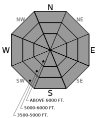
How to read the forecast
Heavy snowfall and gusty winds have teamed up to create very dangerous avalanche conditions and the avalanche danger is HIGH. Large and dangerous storm instabilities will be easily triggered or fail naturally, and very destructive persistent slab avalanches have potential to run full track. Travel in avalanche terrain is not recommended.

4. High
?
Above 6500 ft.
4. High
?
5000-6500 ft.
3. Considerable
?
3500-5000 ft.
- 1. Low
- 2. Moderate
- 3. Considerable
- 4. High
- 5. Extreme
-
Type ?
-
Aspect/Elevation ?

-
Likelihood ?CertainVery LikelyLikelyPossible
 Unlikely
 -
Size ?HistoricVery LargeLargeSmall

Several feet of new snow (up to 3.3" of SWE) in the past 48 hours has formed storm slabs on all aspects and elevations that will be easily triggered or fail naturally. These are largest and most dangerous on higher elevation, windloaded slopes. Touchy storm slabs were observed yesterday (see video) and will be large enough to bury or kill you today. Traveling on or below steep avalanche terrain is not recommended.
-
Type ?
-
Aspect/Elevation ?

-
Likelihood ?CertainVery LikelyLikelyPossible
 Unlikely
 -
Size ?HistoricVery LargeLargeSmall

Significant storm totals are adding stress to persistent slabs 3 to 6 feet thick, over weak, faceted snow. Natural and human-triggered persistent slabs may become reactive today from substantial loading onto a poor snowpack structure. Avalanches of this size could run full track; we recommend reducing your exposure to runout zones, even at lower elevations.
Once again, we find ourselves in the midst of a major winter storm. Storm totals over the last 24 hours: 2.8" SWE in Noisy Basin, 14-17"/ 0.9" SWE in Flathead Range, and 10"/ 1.4 SWE" at Flattop Mountain SNOTEL. Overnight, a natural avalanche was reported running from a small cut bank and hitting the BNSF tracks in the Middle Fork corridor depositing debris 6 feet deep and 40 feet wide. This is bulls-eye data that storm instabilities exist and will be widespread and touchy throughout our forecast area today. Winds are gusting at all elevations today, thickening storm slabs on leeward terrain.
Rapid loading is adding additional stress to a poor snowpack structure with weak, faceted snow now buried 3 to 6 feet deep. This persistent slab problem is becoming more complex with additional loading and adding to uncertainty about its spatial distribution. We had a major natural avalanche cycle throughout our forecast area ending on 12/20 that flushed some but not all of our buried weak layers. Stability test have shown a strengthening snowpack on some slopes while others are still producing propagating results. During a loading event like this and uncertainty surrounding larger, deeper avalanche problems, its best to notch back your terrain choices, including low elevation runout zones, until the dust settles.
Arctic cold front moved through the Flathead Valley overnight, surface flow has shifted to the East, and we can anticipate gusty winds to develop during the day on Friday. Temperatures steadily dropped behind frontal passage with coldest readings being observed in the John F. Stevens Canyon. For today, dump truck of Pacific moisture will continue to move into northwest Montana with a lull in snowfall expected this afternoon before enhancing overnight. Intense snowfall is expected Friday night into Saturday as trough and associated low pressure begin to move inland and transition over northwest Montana. Expect gradually tapering snowfall for Saturday as northwest flow sets up with continued off and on light snow through Sunday.
This advisory applies only to backcountry areas outside established ski area boundaries. This advisory describes general avalanche conditions and local variations always occur. This advisory expires at midnight on the posted day unless otherwise noted. The information in this advisory is provided by the USDA Forest Service who is solely responsible for its content.


