| Wednesday | Wednesday Night | Thursday | |
|---|---|---|---|
| Cloud Cover: | Light snowfall favoring the southern ranges | Light snowfall, favoring the southern ranges | Moderate snowfall, favoring the southern ranges |
| Temperatures: | 14 to 19 deg. F. | 4 to 9 deg. F. | 17 to 23 deg. F. |
| Wind Direction: | West | West | West |
| Wind Speed: | 5 to 15 mph | 5 to 15 mph | 0 to 10 mph |
| Snowfall: | 1 to 3" in. | 1 to 3" in. | 2 to 4" in. |
| Snow Line: |
Whitefish Range
Swan Range
Flathead Range and Glacier National Park
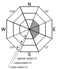
How to read the forecast
It has been a week since our major storm and avalanche cycle, and the snowpack is gradually adjusting. Although the likelihood of triggering a persistent slab avalanche has significantly decreased, the consequences of triggering one of these avalanches remains large and deadly. Carefully assess the snowpack and give yourself a wide buffer to allow for uncertainty when managing this complex problem.

2. Moderate
?
Above 6500 ft.
2. Moderate
?
5000-6500 ft.
2. Moderate
?
3500-5000 ft.
- 1. Low
- 2. Moderate
- 3. Considerable
- 4. High
- 5. Extreme
-
Type ?
-
Aspect/Elevation ?

-
Likelihood ?CertainVery LikelyLikelyPossible
 Unlikely
 -
Size ?HistoricVery LargeLargeSmall

Cohesive slabs from 2 to 4 feet thick overlying weak, faceted snow can be triggered while traveling on or adjacent to steep terrain. These persistent slabs are becoming increasingly stubborn or unreactive to human triggers, but remain a high consequence problem that requires careful snowpack assessments and terrain management. Poor structures (photo) are most common at mid and upper elevations on slopes that didn't previously avalanche during last week's cycle. Collapses or shooting cracks, such as this recent observation, are clear signs of an unstable snowpack, although the absence of these red flags is not a free hall pass. Avoid open, unsupported slopes and steep rollovers to reduce your risk.
-
Type ?
-
Aspect/Elevation ?

-
Likelihood ?CertainVery LikelyLikelyPossible
 Unlikely
 -
Size ?HistoricVery LargeLargeSmall

Winds increased overnight, gusting into the 20s at high elevations. With light density snow available for transport, expect soft and thin slabs of wind drifted snow to be forming below cornices or behind leeward features at wind exposed locations. Blowing snow (such as this observation yesterday), fresh drifts, or denser surface snow are clues that you have found this problem, which could be large enough to knock you over or drag you into an unsavory terrain trap.
The mountains picked up a couple of inches of new snow overnight, with 2-3" expected today. This isn't enough to change the danger or our stubborn persistent slab problem, but watch for the avalanche danger to increase over the next few days with more significant snowfall in the forecast. For today, we added wind slabs back on the list due to increased wind speeds gusting into the 20s overnight and wind transport observed yesterday afternoon from John F Stevens Canyon. Today's new wind slabs are a relatively small and minor problem that should take a back seat to your terrain management and snowpack assessments surrounding the persistent slab issue.
Yesterday's observations from the Swan Range and John F Stevens Canyon both showed poor snowpack structures that are becoming increasingly unreactive under our current benign weather. Yet we recently found propagating and collapsing test results on other slopes (such as Mark's observation from Glacier Park and Zach's observation from the Flathead). These tests, in conjunction with a few reports of collapsing snowpack over the weekend, highlight the potential for human triggering and challenging spatial variability of our buried persistent weak layers. There are fewer slopes and fewer points on these slopes where you could trigger a persistent slab avalanche today, but each piece of steep terrain needs to be assessed on a case by case basis. An avalanche breaking on these layers will be surpisingly large and consequential.
We have a few more seats available for our Motorized Level 1 Class the first weekend of January. Details here.
Moisture has begun to stream over Montana under northwest flow. Modest amounts of low density snowfall will accumulate through the day as the system slowly pushes out the arctic air that has engulfed the mountains all weekend. A stronger pulse of moisture arrives tomorrow and snowfall intensifies on Thursday night. This active snowy pattern continues into the weekend, and we may be looking at several feet of snow when all is said and done. Snowfall totals and warming temperatures will be favoring the southern ranges during this system.
This advisory applies only to backcountry areas outside established ski area boundaries. This advisory describes general avalanche conditions and local variations always occur. This advisory expires at midnight on the posted day unless otherwise noted. The information in this advisory is provided by the USDA Forest Service who is solely responsible for its content.


