THIS AVALANCHE FORECAST EXPIRED ON December 26, 2017 @ 11:16 pm
Avalanche Forecast published on December 26, 2017 @ 6:16 am
Issued by Zach Guy - Flathead Avalanche Center

Whitefish Range
Swan Range
Flathead Range and Glacier National Park

How to read the forecast

The likelihood of triggering a persistent slab avalanche continues to slowly decrease under our stable weather pattern, but the expected size remains the same.   Triggering a surprisingly large and deadly avalanche is possible today.  Carefully assess the snowpack and allow for a large margin of error when choosing terrain.  

2. Moderate

?

Above 6500 ft.
Heightened avalanche conditions on specific terrain features. Evaluate snow and terrain carefully; identify features of concern.

2. Moderate

?

5000-6500 ft.
Heightened avalanche conditions on specific terrain features. Evaluate snow and terrain carefully; identify features of concern.

2. Moderate

?

3500-5000 ft.
Heightened avalanche conditions on specific terrain features. Evaluate snow and terrain carefully; identify features of concern.
    Heightened avalanche conditions on specific terrain features. Evaluate snow and terrain carefully; identify features of concern.
  • 1. Low
  • 2. Moderate
  • 3. Considerable
  • 4. High
  • 5. Extreme
Avalanche Problem 1: Persistent Slab
  • Type ?
  • Aspect/Elevation ?
  • Likelihood ?
    Certain
    Very Likely
    Likely
    Possible
    Unlikely
  • Size ?
    Historic
    Very Large
    Large
    Small

Cohesive slabs from 2 to 4 feet thick overlying weak, faceted snow can be triggered while traveling on or adjacent to steep terrain.  These persistent slabs are becoming increasingly stubborn to human triggers, but remain a high consequence problem that requires careful snowpack assessments and terrain management. Poor structures (photo) are most common at mid and upper elevations on slopes that didn't previously avalanche during last week's cycle.  Collapses or shooting cracks, such as this recent observation,  are clear signs of an unstable snowpack,  although the absence of these red flags is not a free hall pass.  Avoid open, unssuported slopes and steep rollovers to reduce your risk, or default to slope angles less than about 35 degrees when in doubt.  

Forecast discussion

Bulls-eye signs of instability have decreased over the past four days of cold, clear, and calm weather.  Avalanche activity peaked last Tuesday,  while snow loading and frequent reports of a collapsing and cracking snowpack fizzled by Friday morning.  However, our forecast team and many experienced backcountry travelers in the valley continue to excercise caution and patience with this untrustworthy persistent slab issue, and we received two reports of collapsing/whumphing snowpack over the weekend.   Last week's major snow event buried unusually weak and slow-to-heal layers including surface hoar, facets, or faceted crusts by as much as 5" of Snow Water Equivalent.  We continue to observe sudden, propagating failures in wide column tests from all corners of our region, such as Mark's observation from Glacier Park,  Zach's observation from the Flathead, and several public observations from the Whitefish Range (example A, example B).  Compared to last week, there are fewer slopes and fewer points on these slopes where you could trigger a persistent slab avalanche,  BUT the ingredients are still in place for triggering an avalanche up to 4 feet thick.  We aren't out of the woods with this complex problem so continue to bring a cautious mindset into the backcountry. 

Weather and CURRENT CONDITIONS
weather summary

A stationary front is draped across I-90, with a dry, arctic airmass dominating our regional weather pattern today.  The mercury is hovering near zero this morning, and temperatures will struggle to crest above single digits today under calm winds.  Moisture tapping into the subtropical Pacific streams into Montana from Wednesday through Saturday, although the focus of heavy snowfall appears to be aimed to our south. Regardless, light snowfall and warming temperatures return tomorrow and will amplify as the week progresses.  

Two-Day Mountain Weather Forecast Produced in partnership with the Missoula NWS
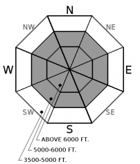
For 5000 ft. to 7000 ft.
Tuesday Tuesday Night Wednesday
Cloud Cover: Multiple down jackets cold Multiple logs on the fire cold. Light snowfall
Temperatures: 7 to 12 deg. F. 0 to 5 deg. F. deg. F.
Wind Direction: West West West
Wind Speed: 0 to 10 mph 0 to 10 mph 0 to 10 mph
Snowfall: 0 in. 0 to 1" in. 1 to 3" in.
Snow Line:
Disclaimer

This advisory applies only to backcountry areas outside established ski area boundaries. This advisory describes general avalanche conditions and local variations always occur. This advisory expires at midnight on the posted day unless otherwise noted. The information in this advisory is provided by the USDA Forest Service who is solely responsible for its content.