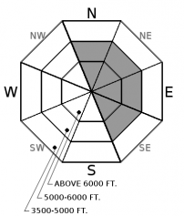
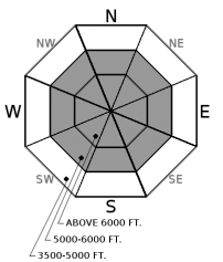
Monday | Monday Night | Tuesday | |
---|---|---|---|
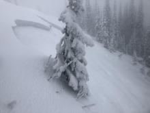
Cloud Cover: | Overcast with moderate precipitation, rising freezing levels and windy conditions. | Heavy snow with breezy conditions. | Continued heavy snow and breezy conditions with lowering snow levels. |
Temperatures: | 29-34 deg. F. | 21-26 deg. F. | 26-31 deg. F. |
Wind Direction: | Southwest | Southwest | South |
Wind Speed: | 10 to 20 mph with gusts to 30 | 5 to 15 mph with gusts to 30 | 5 to 15 mph with gusts to 25 |
Snowfall: | 5 to 9 in. | 6 to 10 in. | 7 to 11 in. |
Snow Line: |
Whitefish Range
Swan Range
Flathead Range and Glacier National Park
How to read the forecast
An AVALANCHE WATCH is in effect. A warm moist storm will be overloading a weak snowpack, and dangerous avalanche conditions are developing. The danger is CONSIDERABLE today above 5000', and could rise to HIGH tomorrow if the forecast verifies. Natural avalanche activity will become increasingly widespread as this system develops. Careful snowpack evaluation, cautious route finding and conservative decision making are essential.

3. Considerable
?
Above 6500 ft.
3. Considerable
?
5000-6500 ft.
2. Moderate
?
3500-5000 ft.
- 1. Low
- 2. Moderate
- 3. Considerable
- 4. High
- 5. Extreme
-
Type ?
-
Aspect/Elevation ?
-
Likelihood ?CertainVery LikelyLikelyPossibleUnlikely
-
Size ?HistoricVery LargeLargeSmall
Southwest winds increased overnight redistributing upwards of 7" of new snow onto leeward and crossloaded slopes resulting in wind loaded slab formation. With an additional 6+" of snow today these slabs will thicken throughout the day. On sunny aspects these slabs are forming on sun crusts and on shaded aspects they are forming on a wind crust. Triggering even a small wind slab today could have significant consequences due to the thin snowpack and numerous exposed hazards. These slabs are fresh and easy to detect by the cracking in the snow surface beneath your skis or machine. Look for pillows of snow below ridgelines and in gullies.
-
Type ?
-
Aspect/Elevation ?
-
Likelihood ?CertainVery LikelyLikelyPossibleUnlikely
-
Size ?HistoricVery LargeLargeSmall
Up to 7" of snow overnight and an additional 6+" today will be warm wet and ideal for storm slab development. On shaded aspects slabs will form on a 6-12" weak layer of snow above a rain crust, while on sunny aspects slabs will form on a slippery sun crust. The ingredients for a slab avalanche are in place and we expect natural avalanche activity to be possible today and likely tomorrow. These avalanches are expected to run long distances and entrain substantial snow. Slabs can be identified by obvious cracking under your feet or machine.
Overnight precipitation totals in the valley floor range from 0.25" in John F. Stevens Canyon to 0.48" in West Glacier with upper elevation weather stations reporting over 1.1" of water at Noisy Basin in the Swan Range, Stahl Peak in the northern Flathead Range and Flattop in central Glacier Park. Due to the warm air temperatures overnight snowfall totals are not that impressive and range up to 7" at upper elevations. The combination of warm air temperatures, abundant moisture and windy conditions is conducive for stormslab and windslab formation at middle and upper elevations. These conditions will affect our area throughout the day leading to continued slab formation on a weak snowpack structure (example A, example B). Dangerous avalanche conditions exist and the hazard may rise with continued moisture tonight and tomorrow. Today is the day to have your avalanche eyeballs wide open while practicing safe travel techniques in unique areas such as valley floor runout zones and lower angle terrain attached to steeper terrain. Expect changing avalanche conditions as the day progresses and evaluate all terrain before committing to a slope.
Thanks to everyone for submitting observations as this helps us to produce a better product.
A powerful warm wet Pacific storm moved into our area last night and will last through the day before a stronger surge of moisture arrives tonight into tomorrow. Currently our area is experiencing moderate precipitation, air temperatures in the upper 20's at upper elevations and light to moderate southwest winds. A stronger system will arrive tonight with heavy precipitation, moderate winds and relatively warm temperatures. Storm totals may reach upwards of 3 feet by Tuesday evening at upper elevations.
This advisory applies only to backcountry areas outside established ski area boundaries. This advisory describes general avalanche conditions and local variations always occur. This advisory expires at midnight on the posted day unless otherwise noted. The information in this advisory is provided by the USDA Forest Service who is solely responsible for its content.