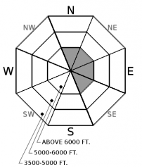
| Saturday | Saturday Night | Sunday | |
|---|---|---|---|
| Cloud Cover: | Mostly cloudy with no precipitation and little fluctuation in temperatures. | Mostly cloudy with no precipitation and little fluctuation in temperatures. | Mostly cloudy with no precipitation and little fluctuation in temperatures. |
| Temperatures: | 25 to 30 deg. F. | 22 to 27 deg. F. | 25 to 30 deg. F. |
| Wind Direction: | West | West | Southwest |
| Wind Speed: | 1 to 11 mph | 1 to 11 mph | 1 to 11 mph |
| Snowfall: | 0 in. | 0 in. | 0 in. |
| Snow Line: |
Whitefish Range
Swan Range
Flathead Range and Glacier National Park
How to read the forecast
The avalanche danger is LOW on all aspects at all elevations due to recent benign weather. Isolated wind slabs exist on upper elevation slopes favored by wind loading. Look for rounded pillows of snow and obvious signs of instability like cracking and collapsing. Evaluate all wind loaded terrain before committing to a slope. Continue to carry avalanche safety gear, practice using it, and follow safe travel techniques that you would mid-winter.

1. Low
?
Above 6500 ft.
1. Low
?
5000-6500 ft.
1. Low
?
3500-5000 ft.
- 1. Low
- 2. Moderate
- 3. Considerable
- 4. High
- 5. Extreme
-
Type ?
-
Aspect/Elevation ?

-
Likelihood ?CertainVery LikelyLikelyPossible
 Unlikely
 -
Size ?HistoricVery LargeLargeSmall

Slabs of windblown snow up to 12" in depth can be found on upper elevation leeward and crossloaded slopes (see this photo). These slabs are mostly shallow and small but in favored wind locations they may be larger. All of these slabs were deposited on top of the Thanksgiving rain crust which could act as a slippery bed surface (see this photo). Most of these features were formed nearly a week ago, and are becoming stubborn to trigger, but lingering instabilities remain in locations where a thin layer of weak snow sits on top of the crust (see this photo). In favored windy locations in alpine terrain more recently formed wind slabs may be found. Getting caught in even a small slide could have significant consequences due to the thin snowpack and numerous exposed hazards. Look for rounded pillows of snow near ridgelines and recognize signs of instability such as cracking or collapsing in the surface snow.
A thick layer of Stratus clouds parked itself over our upper elevation terrain for the past 5 days. The resulting overcast conditions helped to preserve cold low density snow on the surface in sheltered areas at all elevations. In many areas this low density surface snow is not bonding to the underlying Thanksgiving rain crust. The high humidity and light winds within the Status layer has proven to be optimum conditions for surface hoar development at upper elevations. This weak layer is currently not a concern but could become problematic when buried by future storms. At upper elevations winds prior to the Stratus intrusion deposited wind slabs up to 12" thick on the Thanksgiving crust on leeward and cross loaded terrain. Yesterday at Firebrand Pass, outside of our forecast area, a thin layer of facets (weak snow) capped the rain crust and sat below the wind slab (see this observation). Currently our concern in the snowpack is these isolated wind slabs which resemble pillows of snow just below ridgelines and in gully features.
We encourage all of you to submit observations to help improve the quality of our product. Thanks.
A strong ridge of high pressure will continue to build over our area bringing stable conditions with low clouds for at least the next few days. Due to persistent cloud cover, temperatures in the valleys will fluctuate little and remain in the mid to upper 20's. At upper elevation locations that are fortunate enough to be above the low clouds, bluebird days will be the norm with temperatures climbing into the mid to upper 30's with light southwest winds and no precipitation.
| 0600 temperature: | 19 to 25 deg. F. |
| Max. temperature in the last 24 hours: | 26-37 deg. F. |
| Average wind direction during the last 24 hours: | Southwest |
| Average wind speed during the last 24 hours: | 5 to 15 mph |
| Maximum wind gust in the last 24 hours: | 15 to 25 mph |
| New snowfall in the last 24 hours: | 0 inches |
| Total snow depth: | 24 to 30 inches |
This advisory applies only to backcountry areas outside established ski area boundaries. This advisory describes general avalanche conditions and local variations always occur. This advisory expires at midnight on the posted day unless otherwise noted. The information in this advisory is provided by the USDA Forest Service who is solely responsible for its content.


