| Saturday | Saturday Night | Sunday | |
|---|---|---|---|
| Cloud Cover: | Showers with warm temperatures and windy conditions. | Cool temperatures with continued showers and windy conditions. | Cooler temperatures and dry conditions. |
| Temperatures: | 37-51 deg. F. | 14-25 deg. F. | 27-42 deg. F. |
| Wind Direction: | Southwest | Southwest | West-southwest |
| Wind Speed: | 15-18 mph with gusts to 43 | 17-21 mph with gusts to 45 | 10-13 mph with gusts to 36 |
| Snowfall: | 0 in. | 0 in. | 0 in. |
| Snow Line: |
Whitefish Range
Swan Range
Flathead Range and Glacier National Park
How to read the forecast
Warming temperatures combined with light rain overnight and through the day has, and will continue to, elevate the avalanche danger. The avalanche danger is MODERATE at all elevations this morning but may rise to CONSIDERABLE above 6000 feet if forecasted rain amounts materialize. Pay attention to changing conditions at the snow surface and below the surface where free water is percolating through the snow pack.

3. Considerable
?
Above 6500 ft.
2. Moderate
?
5000-6500 ft.
2. Moderate
?
3500-5000 ft.
- 1. Low
- 2. Moderate
- 3. Considerable
- 4. High
- 5. Extreme
-
Type ?
-
Aspect/Elevation ?

-
Likelihood ?CertainVery LikelyLikelyPossible
 Unlikely
 -
Size ?HistoricVery LargeLargeSmall

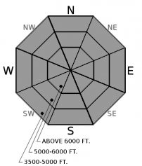
The warm wet weather earlier this week lead to a widespread wet slab avalanche cycle. Mid elevation slopes appeared to produce the majority of the wet slabs observed with many of these failing at the February 9/17 rain crust. Observations show that water is moving through the snowpack and pooling on top of this crust at mid elevations. Wet slabs were observed in upper elevation locations but not to the extent seen at mid elevations. This is due to the free water, in many locations, not moving through the snowpack but instead being confined to the upper portion of the pack. With warming temperatures and rain the wet slab avalanche danger will increase throughout the day primarily at upper elevations but also at isolated mid elevation locations.
-
Type ?
-
Aspect/Elevation ?
-
Likelihood ?CertainVery LikelyLikelyPossible
 Unlikely
 -
Size ?HistoricVery LargeLargeSmall

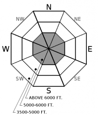
Cool clear conditions locked up the snowpack and created a stout surface crust at all elevations yesterday. Unfortunately that is not the case this morning as warm temperatures and light rain overnight has weakend the snow surface. This surface has been "worked over" by recent warm wet weather so natural avalanche activity will be limited today but it will be possible to trigger a wet loose avalanche. The avalanche danger will increase as the day progresses as temperatures warm and the snow surface becomes saturated from today's forecated rain. Keep in mind that even short seemingly benign slopes can be dangerous when the effects of an avalanche are amplified by terrain traps like narrow gullies, cliffs, and trees.
-
Type ?
-
Aspect/Elevation ?
-
Likelihood ?CertainVery LikelyLikelyPossible
 Unlikely
 -
Size ?HistoricVery LargeLargeSmall

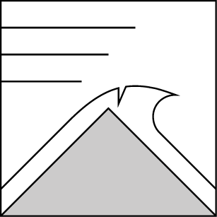
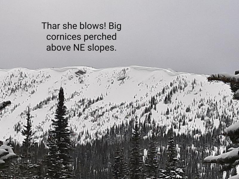
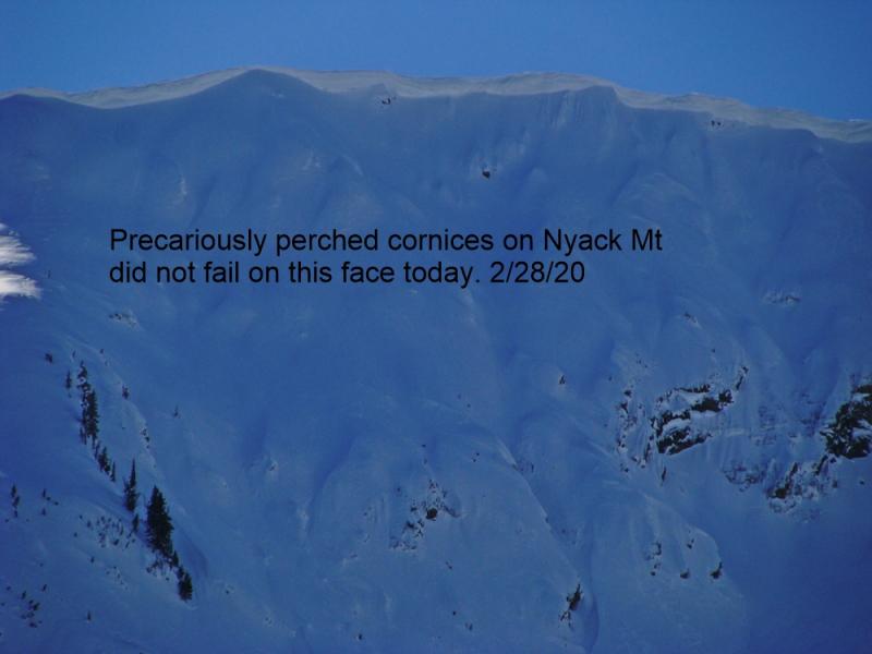
Substantial low density snowfall combined with windy conditions formed large cornices across our area this winter. These wind features had stayed in place for the majority of the winter until recent warm wet weather weakened them. BNSF Avalanche Safety observed cornice failures over the past week in John F. Stevens Canyon in southern Glacier Park and we assume cornice failure also occurred in other mountainous regions of our area. Continued warm temperatures and light rain at upper elevations will further weaken these features today so it is best to stay well away from them while traveling along ridgelines. Falling cornices can trigger avalanches on the slopes beneath them so it is important to minimize exposure to slopes where cornices loom above.
Spring can bring a mixed bag of weather conditions to northwest Montana. It can surprise us with intense snow squalls, warm temperatures, and rain-on-snow events (even in the same day). This makes it increasingly important to closely monitor changing conditions. With longer days and a higher sun angle, conditions can rapidly change.
In isolated areas a layer of weak sugary snow (facets) sitting on top of the Feb. 10th rain crust produced unstable results in stability tests. I suspect that a few natural avalanches that occured recently were associated with that interface. This illustrates the importance of digging into the snow and continuing to assess deeper instabilities particularly after a recent, substantial load. In most locations the Feb. 10 crust is buried 2.5 to 4 feet from the snow surface.
Friday: Mark toured into Rescue Creek in the Flathead Range and observed substantial avalanche activity from the warm wet weather of 3/15. Avalanches were noted on all aspects at all elevations. Avalanche debris traveled the length of the valley floor with a destructive size of D4. A strong surface crust was present on the snow surface at all elevations. Guy rode in Hellroaring Creek in the Mission Mountains and found evidence of recent wet loose and slab avalanches. He also noted glide cracks and a stout surface crust.
Thursday: Adam and Todd were on Tunnel Ridge in the Flathead Range. Temperatures started off warm , but rapidly decreased as a cold front moved into the area. Up to about 6000 feet they found that recent melt and rain water had percolated through the entire snow pack. At 7000 feet only the upper snowpack was moist. Along the ridgeline wind direction was variable with gusts to 45 mph, but only transporting snow on the highest surrounding peaks. WMR Ski Patrol reported natural loose, wet activity in the Skook Chutes with debris all the way to Canyon Creek. They suspected these avalanches to have run on Wednesday (3/15).
Wednesday: BNSF avalanche safety reported natural avalanche activity in the John F. Stevens Canyon. These loose, wet and wet slab avalanches were estimated at size 2-3 and a few reached the valley floor.
See below for all observations this season.
Yesterday, temperatures started out well below freezing at all elevations but rose to above freezing temperatures at all upper elevation weather stations by early afternoon. Temperatures cooled a bit last evening before inching their way up early this morning as a warm moist air mass slowly works its way into our area. Currently, temperatures above 6000' range from 31-40º F with winds of 8-17 mph with gusts to 32. Warm temperatures are on tap for today with light to moderate showers and windy conditions developing this afternoon. Showers continue this evening before tapering off by tomorrow morning.
| 0600 temperature: | 31-40 deg. F. |
| Max. temperature in the last 24 hours: | 32-44 deg. F. |
| Average wind direction during the last 24 hours: | Southwest |
| Average wind speed during the last 24 hours: | 5-15 mph |
| Maximum wind gust in the last 24 hours: | 18-40 mph |
| New snowfall in the last 24 hours: | 0 inches |
| Total snow depth: | 89-120 inches |
This advisory applies only to backcountry areas outside established ski area boundaries. This advisory describes general avalanche conditions and local variations always occur. This advisory expires at midnight on the posted day unless otherwise noted. The information in this advisory is provided by the USDA Forest Service who is solely responsible for its content.


