| Sunday | Sunday Night | Monday | |
|---|---|---|---|
| Cloud Cover: | Precipitation tapering through the day with windy conditions. | Light snow with continued windy conditions. | Warming temperatures with light snow and breezy conditions. |
| Temperatures: | 31-41 deg. F. | 23-30 deg. F. | 35-44 deg. F. |
| Wind Direction: | West-southwest | West-southwest | Southwest |
| Wind Speed: | 13-17 mph with gusts to 33 | 8-12 mph with gusts to 23 | 9-13 mph with gusts to 29 |
| Snowfall: | 0-3 in. | 1-2 in. | 0-3 in. |
| Snow Line: |
Whitefish Range
Swan Range
Flathead Range and Glacier National Park
How to read the forecast
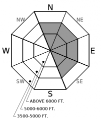
Moderate to strong winds returned to our area last night and will continue through the day forming fresh wind slabs and adding weight to existing slabs. The avalanche danger is CONSIDERABLE above 6000 feet where a human triggered avalanche is likely on typical leeward aspects. Carefully evaluate wind loaded terrain before committing to a slope. Below 6000 feet the danger is MODERATE where heightened avalanche conditions exist due to recent and continued wind loading and rain on snow.

3. Considerable
?
Above 6500 ft.
2. Moderate
?
5000-6500 ft.
2. Moderate
?
3500-5000 ft.
- 1. Low
- 2. Moderate
- 3. Considerable
- 4. High
- 5. Extreme
-
Type ?
-
Aspect/Elevation ?

-
Likelihood ?CertainVery LikelyLikelyPossible
 Unlikely
 -
Size ?HistoricVery LargeLargeSmall

Wind speeds decreased during the day yesterday but ramped up again last night and this morning. These winds are strong enough to move the relatively heavy surface snow onto typical leeward aspects forming fresh wind slabs and adding weight to existing slabs. Moderate sustained winds accompanied by strong gusts will continue to drift snow throughout the day today. Human triggered avalanches are likely on wind loaded terrain today and we recommend that you carefully evaluate all wind loaded terrain before committing to a slope.
Winds and snowfall from the bountiful 2 week storm cycle have formed large cornices across our advisory area. Recent warming temperatures have weakened these features and it is best to give them a wide berth and avoid traveling underneath them.
-
Type ?
-
Aspect/Elevation ?

-
Likelihood ?CertainVery LikelyLikelyPossible
 Unlikely
 -
Size ?HistoricVery LargeLargeSmall

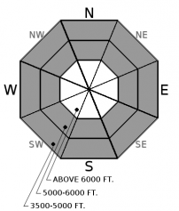
Saturday, sunshine and warm temperatures created heavy wet snow conditions on sunny aspects which caused small loose wet avalanches. Precipitation returned to our area last evening with snow levels above 4000 feet which has resulted in rain at low and possibly even mid elevations. Rain on snow is not a good scenario due to the weight it adds to the surface snow but also the weakening of the surface snow structure. Cloudy conditions today will likely eliminate the potential for upper elevation wet loose slides but we should anticipate the possibility of wet loose activity at both low and mid elevations.
Abundant recent snow formed a hefty slab on top of the February 10 rain crust. In isolated locations (closer to the Continental Divide) a layer of weak sugary snow (facets) sitting on top of this crust fractured and propagated across the column in stability tests. Collapsing on this layer was also reported yesterday in southern GNP. No avalanches have been reported or observed on this layer recently, BUT it is important to assess this layer by digging into the snow. That is the only way you are going to know how a layer this deep is behaving. In most locations this layer existst 2.5 to 4 feet from the snow surface. So, do your homework, and dig into the snow.
Spring can bring a mixed bag of weather conditions to northwest Montana. It can surprise us with intense snow squalls, warm temperatures, and rain-on-snow events (even in the same day). This makes it increasingly important to closely monitor changing conditions. With longer days and higher sun angle conditions can rapidly change.
Saturday: Skiers in the southern Whitefish Range noted numerous small wet loose avalanches in the Skook Chutes, thin wind slabs at upper elevations and heavy wet snow below 5000 feet. Stability tests produced failures with easy force in the top 40 cm but no full propagation was observed.
Friday: Guy and Mark traveled into Noisy Basin in the Swan Range where they observed numerous thin storm slab avalanches at all elevations and on all aspects. The dense 5-6" of new snow overnight had created an upside down snow surface structure and was responsible for these slides. They had failure at several locations in their pit due to density changes in the recent snow. In John F. Stevens Canyon, in southern Glacier Park, BNSF avalanche safety reported a number of storm slab avalanches as the arctic air retreated to the east and the day warmed.
Thursday: Skiers on Paola Ridge in the Flathead Range yesterday observed multiple recent avalanche crowns and witnessed one natural avalanche near the head of Dickey Creek. They suspected these were wind-slab related avalanches. They found deep stable snow conditions and noticed no propagation in their stability tests.
See below for all observations this season.
Yesterday we enjoyed periods of sunshine and above normal temperatures. Valley floor locations reached 53º F in West Glacier and 48º F in John F.Stevens Canyon. Upper elevation locations at Pike Creek, near Marias Pass, recorded 44º F and Noisy Basin, in the Swan Range, topped out at 43º F. Precipitation returned late last night with high snow levels and up to 4" of new snow and 0.4" of water. Currently, temperatures above 6000 feet range from 27-31º F with breezy winds of 7-19 mph with gusts from 20-37. Today we should expect slightly cooler temperatures than yesterday with precipitation tapering throughout the day.
| 0600 temperature: | 27-31 deg. F. |
| Max. temperature in the last 24 hours: | 29-44 deg. F. |
| Average wind direction during the last 24 hours: | Southwest |
| Average wind speed during the last 24 hours: | 6-26 mph |
| Maximum wind gust in the last 24 hours: | 23-39 mph |
| New snowfall in the last 24 hours: | 0-4 inches |
| Total snow depth: | 100-132 inches |
This advisory applies only to backcountry areas outside established ski area boundaries. This advisory describes general avalanche conditions and local variations always occur. This advisory expires at midnight on the posted day unless otherwise noted. The information in this advisory is provided by the USDA Forest Service who is solely responsible for its content.


