| Friday | Friday Night | Saturday | |
|---|---|---|---|
| Cloud Cover: | Tapering snowfall throughout the day. | Snow/rain mix | Overcast and warming |
| Temperatures: | 29-38 deg. F. | 20-27 deg. F. | 34-43 deg. F. |
| Wind Direction: | West-Southwest | West | Southwest |
| Wind Speed: | 8-12 | 10-13 | 14-17 gusts 26 |
| Snowfall: | 2-5 in. | 0 in. | 0 in. |
| Snow Line: |
Whitefish Range
Swan Range
Flathead Range and Glacier National Park
How to read the forecast
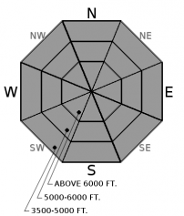
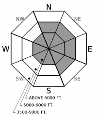
Very dangerous avalanche conditions exist after receiving up to 7" of heavy snow (up to 1" of SWE) overnight. Our storm came in cold but rapidly warmed up this morning, creating “upside-down” storm slabs. These fresh slabs will be very reactive today and could have buried old wind slabs that developed during the last week. The avalanche danger above 6000’ is HIGH. The avalanche danger below 6000’ is CONSIDERABLE. Skiing and riding in avalanche terrain is not recommended today.

4. High
?
Above 6500 ft.
3. Considerable
?
5000-6500 ft.
3. Considerable
?
3500-5000 ft.
- 1. Low
- 2. Moderate
- 3. Considerable
- 4. High
- 5. Extreme
-
Type ?
-
Aspect/Elevation ?

-
Likelihood ?CertainVery LikelyLikelyPossible
 Unlikely
 -
Size ?HistoricVery LargeLargeSmall

Rapidly warming temperatures this morning capping off the end of the storm have created the perfect recipe for storm slabs avalanches. At the Pike Creek SNOTEL a temperature increase of 20º F in one hour was recorded. Similarly a 27º F rise occurred at Shed 7 this morning in only 3 hours. Throughout our advisory area, temperatures are currently near or above freezing. These warmer temperatures produced a heavier layer of snow on top of a softer, lighter layer (an upside down snow structure). These storm slabs will be widespread and sensitive to human triggers today. Obvious indicators of storm slabs include shooting cracks and collapses within the new storm snow. To know what’s under your feet or machine today, dig into the snow and perform stability tests.
-
Type ?
-
Aspect/Elevation ?

-
Likelihood ?CertainVery LikelyLikelyPossible
 Unlikely
 -
Size ?HistoricVery LargeLargeSmall

Variable winds throughout the forecast area have transported the new snow onto all aspects, forming fresh wind slabs. Look for this wind-loaded terrain near ridges and in exposed locations mid-slope at mid and upper elevations. Expect to find the wind slab problem the most widespread near the Continental Divide where winds have been the most constant.
Be cautious of old buried wind slabs that developed during the last week, as they may still be reactive with the additional load of new heavy snow. Also, don’t forget that large cornices have formed over the past week and are still sensitive. Give cornices a wide berth and avoid traveling underneath them.
88 inches of snow accumulated across the advisory area in the past 11 days. Wind speeds ranged from calm to strong over this time as well. However, large cornices formed across the advisory area due to recent strong winds and abundant snow. These cornices loom over exposed leeward slopes in most areas. Minimize the time you spend on the slopes below these beasts and give them a wide margin of safety while traveling above them as they can release further behind the ridge line than expected.
All of this new snow also formed a hefty slab on top of the February 10 rain crust. In isolated locations (closer to the Continental Divide) a layer of weak sugary snow (facets) sitting on top of this layer fractured and propagated across the column in stability tests. Collapsing on this layer was also reported yesterday in southern GNP. No avalanches have been reported or observed on this layer recently, BUT it is important to assess this layer by digging into the snow. That is the only way you are going to know how a layer this deep is behaving. In most locations this layer existst 2.5 to 4 feet from the snow surface. So, do your homework, and dig into the snow.
If you have been in the mountains recently it doesn't look like Spring now, but it is rapidly approaching. Spring can bring a mixed bag of weather conditions to northwest Montana. It can surprise us with intense snow squalls, warm temperatures, and rain-on-snow events (even in the same day). This makes it increasingly important to closely monitor changing conditions. With longer days and higher sun angle conditions can rapidly change.
Thursday: Skiers on Paola Ridge in the Flathead Range yesterday observed multiple recent avalanche crowns and witnessed one natural avalanche near the head of Dickey Creek. They suspected these were wind-slab related avalanches. They found deep stable snow conditions and noticed no propagation in their stability tests.
Wednesday: We rode into the Red Meadow area in the northern Whitefish Range on Wednesday. The moderate/strong winds created large plumes of snow blowing off of upper-elevation ridgelines. We also noted large cornice growth along leeward ridgelines. While skiing along the ridge we saw isolated cracking in the wind drifted snow. We dug a snow pit and did stability tests on a windloaded, north-facing slope and found a series of recent wind slabs. The most recent were 12-14 inches thick and still reactive. In several Extended Column Tests these slabs fractured and propagated with easy force (ECTP 3, 5). BNSF Avalanche Safety reported heavy wind loading on east aspects in the John F Stevens Canyon. Above 5000 feet they found widespread thin, reactive wind slabs. Another notable observation in this area was a reactive layer of facets above the Feb 10 crust that is now 80-90 cm from the surface (video).
Tuesday: Seth was on Blaine Mountain in the Northern Swan Range (observation). He found a lot of previous wind transport near the ridges with impressive cornice build up and some signs of near surface instability. Stability tests in the snowpit identified some weakness in the top 6 inches of the snowpack, otherwise not much to note. A group of skiers in the Baldhead Mountain area of the Flathead Range reported mostly unconsolidated surface snow with no propagation across the column in their stability tests. Skiers in the Essex area in the Flathead Range also found soft conditions with sluffing on steep slopes and isolated areas with thin, reactive wind slabs.
See below for all observations this season.
Yesterday, a storm arrived in the evening and deposited 3-7" of snow overnight throughout the forecast area. The temperatures rapidly warmed this morning to above freezing in most areas. Near the Continental Divide, the arctic air mass still lingers with near 0º F temperatures in places. Light to moderate winds have been variable with the storm and have ranged from our usual southwesterly to atypical northeasterly. Today should see the storm tapering with possible small impulses of snow throughout the day and winds shifting back around to the west/southwest.
| 0600 temperature: | 1-34 deg. F. |
| Max. temperature in the last 24 hours: | 10-34 deg. F. |
| Average wind direction during the last 24 hours: | Variable |
| Average wind speed during the last 24 hours: | 5-15 mph |
| Maximum wind gust in the last 24 hours: | 15-21 mph |
| New snowfall in the last 24 hours: | 3-7" inches |
| Total snow depth: | 95-130 inches |
This advisory applies only to backcountry areas outside established ski area boundaries. This advisory describes general avalanche conditions and local variations always occur. This advisory expires at midnight on the posted day unless otherwise noted. The information in this advisory is provided by the USDA Forest Service who is solely responsible for its content.


