Forecaster Observation - Avalanche in unnamed drainage near Wahoo Creek, Flathead Range

Location Name: 
Unnamed drainage near Wahoo and Cascadilla Creeks, Flathead Range
Region: 
Flathead Range - Middle Fork Corridor
Date and time of avalanche (best estimate if unknown): 
Tue, 02/07/2017 - 04:00
Location Map: 


Observation made by: Forecaster
Avalanche Observations
Avalanche Type: 
Dry
Slope: 
39degrees
Trigger type: 
Natural
Crown Height: 
3 ft
Aspect: 
East
Weak Layer: 
Within storm snow
Avalanche Width: 
1 200ft.
Terrain: 
Near Treeline
Elevation: 
5 600ft.
Bed Surface: 
Old Snow
Avalanche Length: 
4 400ft.
More detailed information about the avalanche: 

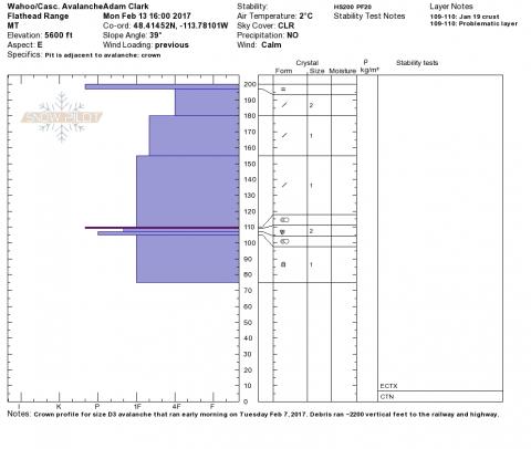
Investigated the avalanche that ran early in the morning on Tuesday, Feb 7, 2017 in an unnamed drainage located at the north end of the ridge dividing Wahoo and Cascadilla Creeks. This was a large avalanche that ran approximately 2200 feet with debris damaging power lines and piling up 5-6 feet deep on the BNSF rail grade. A small amount of debris blasted through thick trees below the railway and dusted Highway 2.

The avalanche failed on the January 19th crust. The slab was 1-4 feet thick and consisted of storm snow that fell Feb 3-7. The crown ran close to 1200 feet horizontally across the western half of the bowl-shaped starting zone (see map).

Snowpit or crown profile photo or graph: 
Wahoo-Cascadilla Avalanche
Avalanche Photos: 
Activity: 
Skiing