| Wednesday | Wednesday Night | Thursday | |
|---|---|---|---|
| Cloud Cover: | Mostly cloudy, light snow showers. | Mostly cloudy, Lingering snow showers. | Mostly cloudy. |
| Temperatures: | 20-28 deg. F. | 7-17 deg. F. | 21-28 deg. F. |
| Wind Direction: | southwest | west | west |
| Wind Speed: | 5-6 | 5-7 | 5-7 |
| Snowfall: | 0-1 in. | 0-1 in. | 0 in. |
| Snow Line: |
Whitefish Range
Swan Range
Flathead Range and Glacier National Park
How to read the forecast
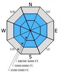
The avalanche danger is MODERATE above 6000 feet. Warmer temperatures and lack of recent snow allowed the snow pack to consolidate and strengthen. However, layers weak snow exist in many areas and human triggered avalanches remain possible. Dig into the snow and evaluate the snow pack before committing to a slope. Look for weak snow with an overlying slab and choose appropriate terrain where present. Avoid steep, rocky areas with shallow snow where you can more easily trigger an avalanche.

2. Moderate
?
Above 6500 ft.
1. Low
?
5000-6500 ft.
1. Low
?
3500-5000 ft.
- 1. Low
- 2. Moderate
- 3. Considerable
- 4. High
- 5. Extreme
-
Type ?
-
Aspect/Elevation ?

-
Likelihood ?CertainVery LikelyLikelyPossible
 Unlikely
 -
Size ?HistoricVery LargeLargeSmall

The relatively warm temperatures over the past week have just begun to strengthen our snowpack. Unfortunately there are multiple buried weak layers located at various depths in our snowpack and they need more than just a few days to heal. It is possible for one or more of these layers to fail given the added weight of a sled or skier. Avoid steep, rocky terrain that often harbors a shallower snowpack. Here you are more likely to trigger one of these persistent weak layers. We have observed very few persistent slab avalanches this season, but do not become complacent about this hazard. Take a little extra time to dig into the snowpack and look for layers of weak snow in areas where you are recreating.
Tuesday: Adam and Todd were on Elk Mountain in southern Glacier National Park and found the breakable Jan. 19 crust buried by only 2-3 cm of snow. Snow coverage was thin and sparse at upper elevations. In wind loaded areas the snow surface was very firm and supportable with poor structure below. They noted well developed depth hoar at the ground and a layer of weak facets 20 cm from the surface. A party of skiers toured Tunnel Creek to Mt. Liebig in the Flathead Range and found 2 inches of snow above the Jan. 19 crust below 6000 feet. Above 6000 feet conditions improved with additional snow on top of the supportable crust. They did not observe any recent avalanche activity or wind loading.
Monday: Erich and Guy rode into China Basin and Werner Peak in the Whitefish Range. They found several weak layers near the surface that are not yet reactive that include surface hoar, the Jan. 19 melt-freeze crust, and a thin layer of facets about 16 inches from the surface as well. Weak, sugary snow also exists near the ground but fractures did not propagate across the column on any layer in stability tests. Skiers in Paola/Dickey Creek in the Flathead Range found about 6 inches of new snow above the Jan. 19 crust, and also found several weaknesses within the top 2 feet of the snow pack, but observed no fracture propagation in their stability tests. BNSF Avalanche Safety toured in John F. Stevens Canyon. They found multiple weak layers in their snow pits, however fractures did not propagate across the column on any layer in stability tests
See below for all observations this season.
Yesterday saw partly cloudy skies with cool temperatures in the low 20s and light winds. Currently, mountain temperatures range from 12-18º F, and winds are out of the southwest at 2-7 mph with gusts from 5-10 mph. Today should bring similar temperatures as yesterday rising to the low-20s with light snow showers, and winds out of the west at 5-10 mph.
| 0600 temperature: | 11-18 deg. F. |
| Max. temperature in the last 24 hours: | 18-23 deg. F. |
| Average wind direction during the last 24 hours: | west-southwest |
| Average wind speed during the last 24 hours: | 5-10 mph |
| Maximum wind gust in the last 24 hours: | 9-15 mph |
| New snowfall in the last 24 hours: | 0 inches |
| Total snow depth: | 52-69 inches |
This advisory applies only to backcountry areas outside established ski area boundaries. This advisory describes general avalanche conditions and local variations always occur. This advisory expires at midnight on the posted day unless otherwise noted. The information in this advisory is provided by the USDA Forest Service who is solely responsible for its content.


