| Wednesday | Wednesday Night | Thursday | |
|---|---|---|---|
| Cloud Cover: | Partly sunny and cooler with N-NE winds | Cool and clear | Partly sunny and cool with S-SW winds |
| Temperatures: | -10 to 11 deg. F. | -16 to -3 deg. F. | 5 to 13 deg. F. |
| Wind Direction: | East to Northeast | Northeast to Northwest | South to Southwest |
| Wind Speed: | 6 to 11 mph | 5to 10 mph | 5 to 10 mph gusts to 20 |
| Snowfall: | 0 in. | 0 in. | 0 in. |
| Snow Line: |
Whitefish Range
Swan Range
Flathead Range and Glacier National Park
How to read the forecast
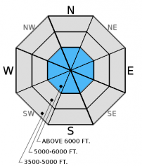
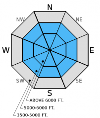
Winds out of the Northeast are transporting recent storm snow onto slopes not normally loaded. The recent storm deposited denser layers of snow onto a layer of lighter, less dense snow, creating dangerous avalanche conditions. It is also possible for avalanches to step down to weak layers that exist deeper in the snowpack. The avalanche danger is CONSIDERABLE above 5000 feet. Human triggered avalanches are likely and conservative decision-making is essential today.

3. Considerable
?
Above 6500 ft.
3. Considerable
?
5000-6500 ft.
2. Moderate
?
3500-5000 ft.
- 1. Low
- 2. Moderate
- 3. Considerable
- 4. High
- 5. Extreme
-
Type ?
-
Aspect/Elevation ?

-
Likelihood ?CertainVery LikelyLikelyPossible
 Unlikely
 -
Size ?HistoricVery LargeLargeSmall

The winds shifted again from the Southwest to Northeast and have been moderate to strong at times. These winds have not been as strong as the wind event from the beginning of January, but will still transport snow onto normally scoured slopes. In many locations these fresh wind slabs have been deposited on a low density snow surface that was in place before the recent storm. Look for signs of recent wind-loading such as smooth rounded pillows on all aspects today, especially above 6000 feet. It is likely that you could trigger a wind slab avalanche today and all wind loaded terrain should be viewed with suspicion.
-
Type ?
-
Aspect/Elevation ?

-
Likelihood ?CertainVery LikelyLikelyPossible
 Unlikely
 -
Size ?HistoricVery LargeLargeSmall

Between 4 and 15 inches of snow have fallen in the last couple of days. Although most of the snow came in Monday, some snow was received through Tuesday. The new snow was deposited onto a colder and less dense snow surface resulting in a classic "upside down" snowpack. This is an unstable scenario and it is likely you could trigger an avalanche in the recent storm snow. Obvious signs of instability are shooting cracks in the snow surface from under your skis or sled and whumpfing sounds resulting from the collapse of the heavier storm slab into the underlying weaker snow.
-
Type ?
-
Aspect/Elevation ?

-
Likelihood ?CertainVery LikelyLikelyPossible
 Unlikely
 -
Size ?HistoricVery LargeLargeSmall

Our snowpack is not the strong northwest Montana snowpack that we are typically accustomed to seeing. There are a variety of weak layers lurking under the snow surface. We have seen only a limited number of avalanches failing on deeper weak layers in the pack this season. This makes these layers a low probability but high consequence scenario. The recent heavy snow load will be a good test of the strength of these layers. We do not yet know the load that these deeper weak layers can handle, so again conservative decision making is essential. Take a little extra time and dig in the snow to look for these buried weak layers. Choose safer terrain where these layers exist.
We are deeply saddened to report that a skier sustained fatal injuries in an avalanche accident on Stanton Mountain in Glacier National Park Thursday, 01/05/2017. We extend our most sincere condolences to the family and friends. FAC staff, along with Glacier National Park Rangers, vistited the site on Friday. We will provide a complete report of their findings within a few days.
Join us on Friday, January 13 at The Stonefly Lounge, in Coram, at 7:00 pm for a free, engaging, and entertaining 1 hour avalanche awareness presentation.
Tuesday: Seth traveled to Kimmerly Basin and found 6 to 10 inches of new snow from the Sunday/Monday storm. Winds from the southwest were actively transporting snow on exposed slopes. A shallow snowpack with depth hoar, but little reaction in stability tests was found on a sw aspect while a much deeper, wind loaded snowpack was found on an east aspect. One to two feet of new and wind loaded snow was on top of a weaker layer of snow that fell on Saturday night. This layer failed and propagated with moderate to hard force and we suspect this is the same layer that failed in the natural avalanche that occurred adjacent to the pit location while we were in the pit.
Monday: BNSF Avalanche Safety toured in John F. Stevens Canyon. They observed an upside down snowpack as a result of the recent snowfall and wind-loading occuring on easterly aspects. In a snow pit at 6000 feet on a southeastern aspect they found a weak snowpack structure with multiple buried weak layers, including depth hoar at the ground. No avalanche activity was observed, but visibility was limited. Skiers in the Wahoo drainage in the Flathead Range found about 12 inches of new snow near 6000 feet and noted the shifting wind directions over the course of the day. They also did not observe any avalanches, but the storm snow was reactive in a snow pit, with propagation in an extended column test with easy force (one tap).
Sunday: Riders in South Canyon of the southern Whitefish Range observed firm snow at low elevations but a soft snow surface at mid and upper elevations.
Friday: Mark and 2 Glacier National Park Rangers visited Mt. Stanton in GNP. They found a relatively shallow snowpack with weak snow at the ground at mid and upper elevations. Wind slabs formed during the New Year's Day arctic intrusion were also noted. BNSF Avalanche Safety toured in John F. Stevens Canyon and observed a variety of wind slabs at mid and upper elevations. Shooting cracks in the surface slab were noted in isolated locations. Depth hoar was found at the bottom of the pack and had developed into larger grains than what was last viewed in this location 2 weeks ago.
See below for all observations this season.
4 to 15 inches of new snow accumulated over the past 48 hours across the advisory area. As of 6:00 a.m., mountain temperatures above 6000 feet are -7 to 5 °F with winds out of the Northeast at 2-11 mph with gusts to 18 mph. A front has passed and bought only light accumulations of snow, but an arctic airmass seeped through the Divide and entered northwest Montana. Winds have shifted to the east and northeast and temperatures have dropped to below zero in many places with the coldest temperatures being at the lower elevations.
| 0600 temperature: | -7 to 5 deg. F. |
| Max. temperature in the last 24 hours: | 1-19 deg. F. |
| Average wind direction during the last 24 hours: | NE |
| Average wind speed during the last 24 hours: | 2 to 22 mph |
| Maximum wind gust in the last 24 hours: | 5 to 27 mph |
| New snowfall in the last 24 hours: | 1 to 3 inches |
| Total snow depth: | 56 to 75 inches |
This advisory applies only to backcountry areas outside established ski area boundaries. This advisory describes general avalanche conditions and local variations always occur. This advisory expires at midnight on the posted day unless otherwise noted. The information in this advisory is provided by the USDA Forest Service who is solely responsible for its content.


