| Tuesday | Tuesday Night | Wednesday | |
|---|---|---|---|
| Cloud Cover: | Cold. | Very cold. | Cold and increasing wind speeds. |
| Temperatures: | -2 to 5 deg. F. | -28 to -11 deg. F. | -2 to 3 deg. F. |
| Wind Direction: | East-Northeast | East-Northeast | East-Northeast |
| Wind Speed: | 5-10 mph with gusts to 20 mph | 5-10 mph | 5-10 mph |
| Snowfall: | 0 in. | 0 in. | 0 in. |
| Snow Line: |
Whitefish Range
Swan Range
Flathead Range and Glacier National Park
How to read the forecast
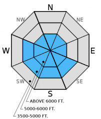
Strong northeast winds formed fresh wind slabs and created hard slabs as well. Careful snowpack evaluation is essential in wind-loaded terrain today. Hard slabs can exist on north, northeast, and east facing terrain, and this type of avalanche could step down to deeper weak layers. The avalanche danger is CONSIDERABLE above 6000 feet, MODERATE at the mid-elevation, and LOW below 5000 feet today.

3. Considerable
?
Above 6500 ft.
2. Moderate
?
5000-6500 ft.
1. Low
?
3500-5000 ft.
- 1. Low
- 2. Moderate
- 3. Considerable
- 4. High
- 5. Extreme
-
Type ?
-
Aspect/Elevation ?

-
Likelihood ?CertainVery LikelyLikelyPossible
 Unlikely
 -
Size ?HistoricVery LargeLargeSmall

Strong northeast winds created fresh wind slabs on Sunday and Monday in terrain located on the southern half of the compass. These winds also formed hard slabs on east, northeast, and north aspects. Yesterday, we even found hard slabs on a rather sheltered northeast slope, and this slab broke with easy force in our stability tests (video). Hard slabs can be identified by your skis or machine not penetrating the surface and hollow sounding snow. These hard slabs are likely to exist on open terrain at upper elevations. Terrain harboring hard wind slabs should be avoided today. Also, pay attention to terrain that is cross loaded by these recent strong winds. The recent skier triggered avalanche in the Skook Chutes in the southern Whitefish Range is a good example of a cross loaded slope.
In most locations across the advisory area there is weak snow buried in the snowpack. These layers include weak snow (facets) formed during the cold period in mid-December (image), facets surrounding an early December rain crust, and weak snow near the ground in areas with a shallow snowpack. Though these layers have been dormant all season (i.e. no avalanches reported involving these layers) it is extremely important to not let your guard down. There is a lot of uncertainty around how much of a load they can handle before they potentially become a problem. Newly formed hard wind slab avalanches can also step down to these deeper weak layers. The most common places to trigger these deeper slides are in steep, rocky terrain, and areas with a relatively shallow snowpack. Erich wrote about this in the new Forecaster's Corner.
Monday: We visited the southern Whitefish Range outside the boundary of Whitefish Mountain Resort. We found hard wind slabs on northeast aspects as well as weaker faceted snow 2.5 feet deeper in the snowpack that fractured and propagated in our stability tests.
Sunday: Zach Miller, the FAC intern, toured to Snowshed Mountain in the Flathead Range where he found instabilities in his snowpit confined to a density change in 2 locations within the top 2 feet of the surface.
Saturday: Mark visited Wahoo Creek in the Flathead Range where he found wind affected snow at all elevations. The surface wind slab was sitting on top of weak low density snow and would easily break under the weight of skis.
See below for all observations this season.
The arctic air mass continues to hold strong over the advisory area. Moderate to strong northeast winds continued until subsiding early this morning across the advisory area. As of 5:00 am, current temperatures above 6000 feet range from -14º to -1.5º F, and northeast winds are 5-7 mph with gusts to 10 mph. Continued cold conditions and decreasing winds are expected through tonight.
| 0600 temperature: | -14 to -1.5 deg. F. |
| Max. temperature in the last 24 hours: | -3 to 3.2 deg. F. |
| Average wind direction during the last 24 hours: | Northeast |
| Average wind speed during the last 24 hours: | 5-17 mph |
| Maximum wind gust in the last 24 hours: | 16-32 mph |
| New snowfall in the last 24 hours: | 0 inches |
| Total snow depth: | 54-71 inches |
This advisory applies only to backcountry areas outside established ski area boundaries. This advisory describes general avalanche conditions and local variations always occur. This advisory expires at midnight on the posted day unless otherwise noted. The information in this advisory is provided by the USDA Forest Service who is solely responsible for its content.


