| Thursday | Thursday Night | Friday | |
|---|---|---|---|
| Cloud Cover: | Mostly cloudy with light snow showers. | Light/moderate snow. | Mostly Cloudy with light to moderate snow showers. |
| Temperatures: | 18-30 deg. F. | 15-24 deg. F. | 22-30 deg. F. |
| Wind Direction: | south/southwest | southwest | west |
| Wind Speed: | 7-10 gusts 20-28 | 11-16 gusts 24-32 | 6-9 gusts 16-23 |
| Snowfall: | 0-1 in. | 3-5 in. | 0-4 in. |
| Snow Line: |
Whitefish Range
Swan Range
Flathead Range and Glacier National Park
How to read the forecast
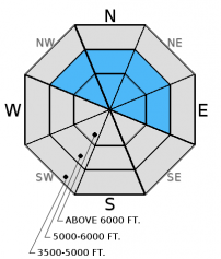
Moderate to strong wind over the past few days drifted the recent snow and created fresh wind slabs on leeward slopes and cross loaded mid-elevation features. The avalanche danger is MODERATE above 5000 feet where human triggered avalanches are possible. Carefully evaluate recently wind loaded slopes before skiing or riding on them.

2. Moderate
?
Above 6500 ft.
2. Moderate
?
5000-6500 ft.
1. Low
?
3500-5000 ft.
- 1. Low
- 2. Moderate
- 3. Considerable
- 4. High
- 5. Extreme
-
Type ?
-
Aspect/Elevation ?

-
Likelihood ?CertainVery LikelyLikelyPossible
 Unlikely
 -
Size ?HistoricVery LargeLargeSmall

Moderate winds with strong gusts over the past 48 hours drifted the recent storm snow and built fresh wind slabs. In some areas these slabs may be 3-4 feet thick along exposed ridgelines. Additionally, winds funneling through canyons cross-loaded mid-slope terrain features so you're not necessarily out of the woods once you drop below the ridges. In isolated areas, reports of prolonged periods of graupel during the recent storm will increase instability of recent slabs formed on this layer. Wind loaded terrain is easily identified by looking for smooth, rounded features on the snow surface. Watch for obvious signs of instability like cracking and collapsing while traveling along ridgelines and riding over low consequence wind loaded features.
Continue to assess the snowpack for potential weak layers like surface hoar and weak, faceted snow that formed during the cold period from 12/13 to 12/19. In areas where a hard wind slab overlies these layers and, with the recent storm load, these layers could become reactive. Look for these weak layers 2-4 feet from the surface. While these layers have not shown obvious signs of instability nor have they been reactive in stability tests, they should not be ignored. In some locations, like John F. Stevens Canyon and areas near the Continental Divide you may find weak (faceted) snow around crusts near the ground (video). The most common places to trigger these deeper slides are in steep, rocky terrain, and areas with a relatively shallow snowpack.
Skiers in the Essex Mountain area in the Flathead Range yesterday noted obvious signs of instability like collapsing (whumfing) in recently wind loaded terrain. they also observed cross-loaded slopes in the upper elevations. Another party nearby did not observe any obvious signs of instability but noted an upside down snow pack near the ridgeline.
Tuesday: BNSF Avalanche Safety reported avalanche debris at about 4800 feet in John F. Stevens Canyon in southern Glacier Park. Visibility was poor and they could not see the starting zone. Skiers in Pinnacle Creek in the Flathead Range reported poor stability involving the new storm snow in stability tests as well as cracking of this new surface snow. They also reported fracturing and propagation on a layer of weak facets near the bottom of a shallow snowpack.
Todd and Seth traveled from the Canyon Creek TH to Werner Peak in the South Whitefish Range. Visibility was very poor because of snow fall and winds. They observed very small slides on the steep cut banks above the Canyond Creek Road that likely took place at the beginning of the storm cycle. Wind loading was obvious on exposed slopes. They also found weak facets at the ground in a shallow pit on a southwest aspect.
See below for all observations this season.
In the last 24 hours we squeezed up to an additional 2 inches of snow out of the passing storm. Wind speeds averaged 10-15 mph with gusts from 25-42 mph out of the southwest. At 6:00am temperatures above 6000 feet range from 11º-17º F, and winds remain out of the west/southwest at 7-12 mph with gusts from 8-19 mph. Today should bring partly/mostly cloudy skies with light snow showers and southwest winds blowing at 5-15 mph with gusts in the 30s. Another system moves in from the north tonight with a few more inches expected by tomorrow morning.
| 0600 temperature: | 11-19 deg. F. |
| Max. temperature in the last 24 hours: | 13-21 deg. F. |
| Average wind direction during the last 24 hours: | SW |
| Average wind speed during the last 24 hours: | 5-15 mph |
| Maximum wind gust in the last 24 hours: | 13-42 mph |
| New snowfall in the last 24 hours: | 0-2 inches |
| Total snow depth: | 52-73 inches |
This advisory applies only to backcountry areas outside established ski area boundaries. This advisory describes general avalanche conditions and local variations always occur. This advisory expires at midnight on the posted day unless otherwise noted. The information in this advisory is provided by the USDA Forest Service who is solely responsible for its content.


