| Tuesday | Tuesday Night | Wednesday | |
|---|---|---|---|
| Cloud Cover: | Snow and wind. | Snow and wind. | Storm tapers with light snow. |
| Temperatures: | 21 to 29 deg. F. | 15 to 22 deg. F. | 20 to 29 deg. F. |
| Wind Direction: | Southwest | Southwest | Southwest |
| Wind Speed: | 17-40 mph with gusts to 40 mph | 15-20 mph with gusts to 40 mph | 10-15 mph with gusts to 35 mph |
| Snowfall: | 5-10 in. | 1-4 in. | 1-3 in. |
| Snow Line: |
Whitefish Range
Swan Range
Flathead Range and Glacier National Park
How to read the forecast
The current storm will cause dangerous avalanche conditions today. As the day progresses, unstable conditions will become more widespread. Human triggered avalanches are likely and natural avalanches are possible. The avalanche danger above 5000 feet is CONSIDERABLE and could rise to HIGH by this evening. Below 5000 feet, the danger is MODERATE where it is possible to trigger an avalanche.

3. Considerable
?
Above 6500 ft.
3. Considerable
?
5000-6500 ft.
2. Moderate
?
3500-5000 ft.
- 1. Low
- 2. Moderate
- 3. Considerable
- 4. High
- 5. Extreme
-
Type ?
-
Aspect/Elevation ?

-
Likelihood ?CertainVery LikelyLikelyPossible
 Unlikely
 -
Size ?HistoricVery LargeLargeSmall

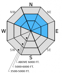
You are likely to trigger a wind slab avalanche at upper and mid-elevations today. The incoming new snow combined with strong (25-40 mph) to extreme (up to 60 mph gusts) wind speeds will form sensitive wind slabs at all elevations. At upper elevations, these slabs could be up to 2.5 feet thick. This problem will become more widespread as the day progresses and the storm intensifies. Avoid wind loaded or cross-loaded terrain completely today as you will likely see small avalanches in many areas or large avalanches in exposed, wind loaded terrain.
-
Type ?
-
Aspect/Elevation ?

-
Likelihood ?CertainVery LikelyLikelyPossible
 Unlikely
 -
Size ?HistoricVery LargeLargeSmall

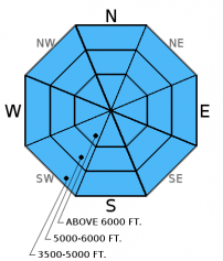
As new snow accumulates, storm slab avalanches will become more likely. This new snow is falling on a layer of lower density snow from yesterday (12/26), and this layer is unlikely to support this new snow on steep (>35 degree) slopes. Watch for obvious signs of instability like recent avalanche activity, cracking out from your sled or skis, and whumpfing of the snowpack. Stick to low angled slopes and avoid runout zones today to avoid this avalanche problem. Loose snow sluffs involving the new storm snow are also possible today in steep terrain.
Dangerous avalanche conditions will develop today, and the avalanche danger could rise to HIGH by tonight. I expect human triggered avalanches and some natural activity to occur today and avalanche activity to peak by tomorrow morning given the current forecast. Prior to this storm, decent stability existed across the advisory area, but now it's time to dial it back. Allow the snowpack time to adjust to this new storm load, and stick to low angled slopes.
Hard wind slabs formed last week could become a problem with today's new storm load. It's important to assess the middle snowpack for potential weak layers like surface hoar and weak, faceted snow that formed during the cold period from 12/13 to 12/19. The hard wind slab overlies these layers and, with today's new storm load, these layers could become reactive. Look for these weak layers 2-4 feet from the surface. While these layers have not shown obvious signs of instability nor have they been reactive in stability tests, they should not be ignored. In some locations, like John F. Stevens Canyon and areas near the Continental Divide you may find weak (faceted) snow around crusts near the ground (video). The most common places to trigger these deeper slides are in steep, rocky terrain, and areas with a relatively shallow snowpack.
Join us at the Kalispell Brewing Company tonight, December 27 to support a great cause by drinking delicious, locally-made beer. Kalispell Brewing will donate $1.00 per every beer sold to Friends of Flathead Avalanche Center (FOFAC) between 5:00 and 8:00 p.m. See you at the brewery!
Monday: We traveled throughout the Lost Johnny range where we found variability in snow depths and snow structure on a variety of aspects in our snow pits. We observed no obvious signs of instability, but this will change today. BNSF Avalanche Safety reported wind loading and very small wind slabs. Skiers in the Jewel Basin also reported wind loading in the Swan Range.
Sunday: WMR ski patrol reported wind loading from northerly winds with localized cracking of wind slabs. Skiers in the Skyland area of the Flathead Range reported easterly winds loading westerly aspects. They found a rain crust/surface hoar near the bottom of the snowpack but stability results did not produce any propagation.
See below for all observations this season.
A potent storm began early this morning and will continue through tomorrow morning. As of 6:00 a.m., 2-5 inches of new snow has accumulated across the advisory area. Currently, mountain temperatures above 6000 feet range from 11-18º F, and winds are out of the southwest at 4-16 mph with gusts from 11-31 mph. Today, temperatures will range from 19-24º F with strong southwest winds. Expect 10-12 inches of new snow (0.4 to 0.9 inches of snow water equivalent) by tonight with continued strong southwest winds.
| 0600 temperature: | 11 to 17 deg. F. |
| Max. temperature in the last 24 hours: | 11 to 18 deg. F. |
| Average wind direction during the last 24 hours: | Southwest |
| Average wind speed during the last 24 hours: | 3-25 mph |
| Maximum wind gust in the last 24 hours: | 10-41 mph |
| New snowfall in the last 24 hours: | 2-5 inches |
| Total snow depth: | 47-67 inches |
This advisory applies only to backcountry areas outside established ski area boundaries. This advisory describes general avalanche conditions and local variations always occur. This advisory expires at midnight on the posted day unless otherwise noted. The information in this advisory is provided by the USDA Forest Service who is solely responsible for its content.


