| Sunday | Sunday Night | Monday | |
|---|---|---|---|
| Cloud Cover: | Cold front bringing strong wind gusts and lowering snow levels. | Decreasing showers. | Showers return to the area in the afternoon. |
| Temperatures: | 37-48 deg. F. | 23-29 deg. F. | 34-46 deg. F. |
| Wind Direction: | SW | SW | SW |
| Wind Speed: | 16-18 gusts 36-37 | 13-16 gusts 25-33 | 6-7 gusts 17 |
| Snowfall: | 0-1 in. | 0-1 in. | 0 in. |
| Snow Line: |
Whitefish Range
Swan Range
Flathead Range and Glacier National Park
How to read the forecast
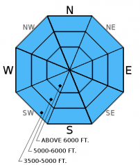
The avalanche danger will begin MODERATE, but additional rain and snow today will cause the hazard to rise to CONSIDERABLE. Wet snow avalanche problems will continue with warm temperatures and continued rain. In the upper elevations look for fresh, reactive windslabs and pay attention to new slab formation at lowering levels as the day progresses. In isolated areas a cohesive slab exists over a layer of buried surface hoar.

3. Considerable
?
Above 6500 ft.
2. Moderate
?
5000-6500 ft.
1. Low
?
3500-5000 ft.
- 1. Low
- 2. Moderate
- 3. Considerable
- 4. High
- 5. Extreme
-
Type ?
-
Aspect/Elevation ?

-
Likelihood ?CertainVery LikelyLikelyPossible
 Unlikely
 -
Size ?HistoricVery LargeLargeSmall

In areas that did return to freezing overnight it was only for a brief period. 0.2-0.5 inches of water in the past 24 hours translated to rain up to about 7000 feet or wet, heavy snow above that. A cold front is expected to move through the area today and lower snow levels, but not before we receive another shot of upper-elevation rain this morning. Warm temperatures and rain over the past few days weakened the snow surface. If you venture into the backcountry today expect to trigger loose, wet avalanches on steep slopes. Even though wet, loose avalanches are a manageable problem they can entrain a lot of snow and have severe consequences. They pile up quickly in narrow gullies and can run you through the trees.
-
Type ?
-
Aspect/Elevation ?

-
Likelihood ?CertainVery LikelyLikelyPossible
 Unlikely
 -
Size ?HistoricVery LargeLargeSmall

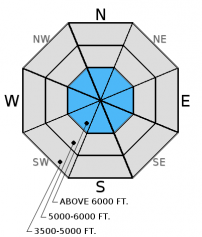
A layer of buried surface hoar exists 6-14 inches below the surface in some areas. In recent observations, this layer fractured in most stability tests, but only propagated in isolated areas. This could change with the combination of recent warm temperatures, wind drifting, and the stress added by the additional load today. Buried surface hoar is tricky to manage due to the variability in distribution. It is important to dig into the snow, see where the layer is, and test the reactivity of this layer with stability tests before committing to a slope.
-
Type ?
-
Aspect/Elevation ?

-
Likelihood ?CertainVery LikelyLikelyPossible
 Unlikely
 -
Size ?HistoricVery LargeLargeSmall

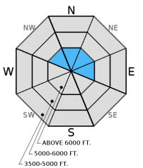
Due to the high snow levels yesterday and this morning fresh windslabs will be confined to the upper elevations. As the snow level drops today expect to see thin slabs forming progressively lower. In some areas slabs may have formed on a preserved layer of surface hoar making them more sensitive.
Additional Concern: Recent strong winds have added size and weight to existing cornices. Continued warm temperatures and winds adding additional weight could cause cornices to become unstable. As we approach spring and daily maximum temperatures rise above freezing, cornices will likely become more sensitive. Cornice failure can also be triggered by the weight of a skier or rider, and Tuesday we found cornices that failed easily from the weight of a skier (observation). Cornices can also trigger slab avalanches on the slopes below making the consequences more severe. Give these large masses of overhanging snow a wide berth while traveling along ridges and limit your exposure time when traveling below them.
Saturday: Snow bikers were in the Red Meadow area in the northern Whitefish Range and observed natural loose, wet avalanche activity in the afternoon (photo). They also noted southwest winds cross-loading slopes and increasing the size of cornices in the area. We were on Skookoleel Ridge in the southern Whitefish Range. On slopes that were exposed to the sun on the previous day we found a supportable surface crust. On previously shaded aspects the unconsolidated snow was getting moist and roller balls formed in steeper terrain in the afternoon (observation). In isolated areas we found buried surface hoar about 14 inches from the surface (photo). Stability test results were variable due to variability in slab formation above. In one location where a soft windslab had formed, the surface hoar fractured and propagated across the column with hard force.
Friday: Skiers on Essex and Snowshed Mountains in the Flathead Range reported two weak interfaces in the upper-snowpack. They observed evidence of recent wind loading, and noted a thin crust forming on north facing slopes in the afternoon (observation). Skiers in the Apgar Range in Glacier National Park found a thin (9 inches), firm slab that fractured and propagated with hard force in extended column tests (observation).
Thursday: Skiers in the Marion Lake area of the Flathead Range reported a couple of recent and somewhat reactive graupel layers within the top foot of the snowpack (observation).
Wednesday: In Cascade Creek in the Flathead Range, we found stubborn wind slabs on wind loaded slopes, but still did not trust wind loaded terrain. We also found buried surface hoar 6-14 inches from the surface in more shaded areas sheltered from the wind (observation) that fractured but did not propagate in extended column tests. Lower elevation snowpack is dwindling rather quickly and has become more spring-like.
Visit our Observations page and our You Tube channel for more observations from the entire season.
Thanks to everyone for submitting observations. They are extremely useful and could help save lives.
HOW TO SUBMIT OBSERVATIONS:
Email: [email protected]
Call and leave a message: 406.387.3821
You can also submit quick observations via text: 406.241.4571 (FAC mobile)
OR
Submit Snowpack Observations: http://www.flatheadavalanche.org/node/add/snowobs
Submit Avalanche Observations: http://www.flatheadavalanche.org/node/add/avyobs
Yesterday warm temperatures continued, and we picked up a bit of rain and wet, heavy snow. SNOTEL sites recorded between 0.2 and 0.5 inches of water. Winds were out of the southwest at 5-18 mph with gusts from 23-34 mph. Currently, mountain temperatures range from 34º-40º F, and winds are out of the south and southeast at 8-11 mph with gusts from 17-18 mph. Today we should see continued showers. A cold front is expected to move through the area in the late morning and begin to lower the snow levels. Winds will blow out of the southwest at 5-15 mph with strong gusts associated with the passing front.
| 0600 temperature: | 34-40 deg. F. |
| Max. temperature in the last 24 hours: | 33-40 deg. F. |
| Average wind direction during the last 24 hours: | SW |
| Average wind speed during the last 24 hours: | 5-15 mph |
| Maximum wind gust in the last 24 hours: | 23-34 mph |
| New snowfall in the last 24 hours: | 0-1 inches |
| Total snow depth: | 75-100 inches |
This advisory applies only to backcountry areas outside established ski area boundaries. This advisory describes general avalanche conditions and local variations always occur. This advisory expires at midnight on the posted day unless otherwise noted. The information in this advisory is provided by the USDA Forest Service who is solely responsible for its content.


