| Saturday | Saturday Night | Sunday | |
|---|---|---|---|
| Cloud Cover: | Snow showers with gradually lower snow levels and strong winds. | Tapering showers. | Showers resume in afternoon. |
| Temperatures: | 35-45 deg. F. | 24-30 deg. F. | 35-47 deg. F. |
| Wind Direction: | W-SW | W-SW | SW |
| Wind Speed: | 14-17 gusts 25-32 | 12-15 gusts 28-32 | 14-18 gusts 28-39 |
| Snowfall: | 0-4 in. | 0-1 in. | 0-3 in. |
| Snow Line: |
Whitefish Range
Flathead Range and Glacier National Park
How to read the forecast
The avalanche danger is MODERATE above 5000 feet. Given the lack of substantial re-freeze, increasing wind, and additional rain/snow expected today human triggered avalanches are possible. Pay close attention to changing weather conditions. We are dealing with a surface hoar layer that could create dangerous conditions with more snow than expected. The Swan Range is expected to be favored with precipitation totals, but the danger could rise to CONSIDERABLE in other areas with storm and wind slabs that form today.

2. Moderate
?
Above 6500 ft.
2. Moderate
?
5000-6500 ft.
1. Low
?
3500-5000 ft.
- 1. Low
- 2. Moderate
- 3. Considerable
- 4. High
- 5. Extreme
-
Type ?
-
Aspect/Elevation ?

-
Likelihood ?CertainVery LikelyLikelyPossible
 Unlikely
 -
Size ?HistoricVery LargeLargeSmall

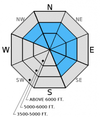
Winds earlier in the week drifted the recent storm snow and created wind slabs on leeward slopes and cross-loaded mid-elevation terrain. Moderate/strong winds overnight and along the divide yesterday likely continued to drift the recent snow that was not baked by the sun. An additional concern with new wind slabs is the wide spread surface hoar that may be preserved beneath them. Continue to carefully evaluate windloaded terrain, particularly in the upper elevations where new snow is drifting today. Look for rounded pillows of wind drifted snow on leeward sides of ridges and cross-loaded areas in gullies at both mid and upper elevations.
-
Type ?
-
Aspect/Elevation ?

-
Likelihood ?CertainVery LikelyLikelyPossible
 Unlikely
 -
Size ?HistoricVery LargeLargeSmall

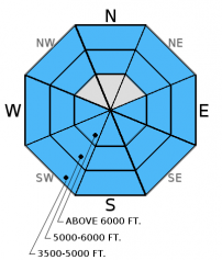
Temperatures remained above freezing in most locations overnight and the potential exists to see rain on snow this morning. Until temperatures begin to fall and refreeze the surface snow it will remain possible to trigger loose, wet avalanches. Pay attention to changing conditions today. Rain on snow will cause rapid surface instability so consider moving to less steep terrain and avoid traveling in or near terrain traps.
-
Type ?
-
Aspect/Elevation ?

-
Likelihood ?CertainVery LikelyLikelyPossible
 Unlikely
 -
Size ?HistoricVery LargeLargeSmall

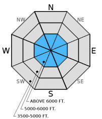
Storm slabs will not be a problem initially today. However, with weather moving into the area the potential to form storm slabs on top of surface hoar as the day progresses warrants careful attention. A new slab formed today should be treated as dangerous given the widespread distribution of surface hoar. If slabs do begin to form choose low angle, simple terrain to ski or ride in.
This season we dealt with an ever evolving persistent slab problem associated with widespread rain crusts and weak snow surrounding these crusts. As time has passed so has our concern with some of these rain crusts. Currently, we are still tracking the strength of the snow around the January 28 and February 14 crusts. The Valentine's Day crust now has 1.5-3 feet of snow sitting on top of it. In recent observations we found a thin layer of facets above this crust. Keep in mind that even small avalanches can step down into this deeper layer.
As our mid winter snowpack transitions into a spring snowpack glide cracks are beginning to form. On Monday we observed a recently formed glide crack in the Kimmerly Basin area of the southern Whitefish Range, and others have reported isolated areas with glide cracks (observation). Glide avalanches are notoriously difficult to predict. It is best to simply avoid slopes with glide crack present (photo).
Friday: Skiers in Rescue Creek in the Flathead Range witnessed large loose, wet avalanches on sunny slopes (observation). Skiers east of Marias Pass in the Flathead Range found variable snow conditions and noted strong winds and active wind drifting (observation). Erich was instructing an avalanche class in the southern Whitefish Range and observed small, loose wet avalanches (photo) and noted widespread surface hoar formation. Skiers on Skookoleel Ridge in the southern Whitefish Range found large surface hoar on multiple aspects that remained preserved through the heat of the day. They also observed large cornices that showed signs of weakening due to rising temperatures (observation).
Thursday: We skied into Wahoo Creek in the Flathead Range. With nearly perfect visibility we could see many of the surrounding peaks and noted recently wind loaded and cross loaded slopes, as well as large cornices along leeward ridgelines. The snow surface was moist by afternoon on sunny slopes and we saw a few small, loose, wet avalanches and rollerballs. It was interesting that as we skied into mid-elevation terrain that the recent wind slabs were more firm and slightly more reactive than up high. Skiers touring from Ouzel Peak to Skiumah Creek also in the Flathead Range found variable ski conditions and surface hoar forming on multiple aspects but variable in distribution (observation).
Wednesday: Skiers in the southern Whitefish Range reported widespread surface hoar development, new glide cracks that have formed and minimal solar affect on sunny aspects (observation, observation).
Visit our Observations page and our You Tube channel for more observations from the entire season.
Thanks to everyone for submitting observations. They are extremely useful and could help save lives.
HOW TO SUBMIT OBSERVATIONS:
Email: [email protected]
Call and leave a message: 406.387.3821
You can also submit quick observations via text: 406.241.4571 (FAC mobile)
OR
Submit Snowpack Observations: http://www.flatheadavalanche.org/node/add/snowobs
Submit Avalanche Observations: http://www.flatheadavalanche.org/node/add/avyobs
Yesterday we enjoyed another warm, sunny day. Temperatures climbed to the upper-30s and mid-40s. Winds were out of the west-southwest at 5-15 mph with gusts from 20-45 mph. Most locations above 6000 feet remained above freezing overnight. Currently, mountain temperatures range from 32º-39º F, and winds are out of the west-southwest at 4-19 mph with gusts from 13-29 mph. For today, rain/snow showers move into the area this morning with snow levels beginning above 6000 feet. The Swan Range looks like it will be favored with precipitation totals. Temperatures and snow levels should gradually decrease through the day. Winds are expected to continue out of the west and southwest at 10-20 mph with gusts from 30-40 mph.
| 0600 temperature: | 32-38 deg. F. |
| Max. temperature in the last 24 hours: | 38-44 deg. F. |
| Average wind direction during the last 24 hours: | WSW |
| Average wind speed during the last 24 hours: | 5-15 mph |
| Maximum wind gust in the last 24 hours: | 20-45 mph |
| New snowfall in the last 24 hours: | 0 inches |
| Total snow depth: | 73-94 inches |
This advisory applies only to backcountry areas outside established ski area boundaries. This advisory describes general avalanche conditions and local variations always occur. This advisory expires at midnight on the posted day unless otherwise noted. The information in this advisory is provided by the USDA Forest Service who is solely responsible for its content.


