| Friday | Friday Night | Saturday | |
|---|---|---|---|
| Cloud Cover: | Intermittent snow showers. Locally heavy snow bands possible at times. Mostly tapering, though. | Next pulse of snow moves through region with continued strong winds. | Snow showers with moderate to strong winds. |
| Temperatures: | 32 to 43 deg. F. | 22 to 28 deg. F. | 28 to 38 deg. F. |
| Wind Direction: | Southwest | Southwest | Southwest |
| Wind Speed: | 13-18 with gusts to 40 mph. | 12 to 16 mph with gusts to 40 mph. | 15-25 mph with gusts to 40 mph. |
| Snowfall: | 1-2 in. | 2-4 in. | 2-3 in. |
| Snow Line: |
Whitefish Range
Swan Range
Flathead Range and Glacier National Park
How to read the forecast
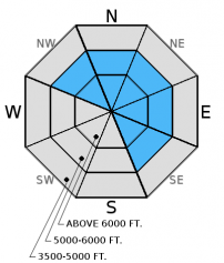
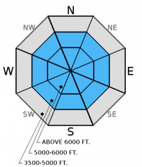
Continued strong winds combined with new snow since yesterday afternoon created sensitive wind slabs. Human triggered avalanches are likely in wind loaded areas and possible in more sheltered areas. Natural avalanches are also possible. Cautious route finding and conservative decision making are essential today. Weak layers near crusts 1-4 feet from the surface also require careful snowpack evaluation. The danger is CONSIDERABLE above 5000 feet and MODERATE below.

3. Considerable
?
Above 6500 ft.
3. Considerable
?
5000-6500 ft.
2. Moderate
?
3500-5000 ft.
- 1. Low
- 2. Moderate
- 3. Considerable
- 4. High
- 5. Extreme
-
Type ?
-
Aspect/Elevation ?

-
Likelihood ?CertainVery LikelyLikelyPossible
 Unlikely
 -
Size ?HistoricVery LargeLargeSmall

Yesterday, wind slabs were very touchy, but thin (3-5 inches), in the early afternoon. With continued strong winds and more snow last night, I expect wind slab avalanches to be very sensitive and prone to human triggering today. They could also be up to 2 feet thick at upper elevations. Natural wind slab avalanches are also possible in the upper elevation zones today. Consistently strong to extreme winds for 20 hours have also likely formed wind slabs in atypical locations (such as cross-loaded gullies). Plumes of snow blowing off the ridges could be seen in the Swan Range from the valley and from Highway 2 adjacent to GNP. Look for rounded pillows of wind drifted snow on leeward sides of ridges and cross-loaded areas in gullies at both mid and upper elevations, and carefully evaluate all wind loaded terrain.
-
Type ?
-
Aspect/Elevation ?

-
Likelihood ?CertainVery LikelyLikelyPossible
 Unlikely
 -
Size ?HistoricVery LargeLargeSmall

The Valentine's Day (2/14) rain crust now has 12-26 inches of snow sitting on top of it. This crust has a thin layer of small faceted snow sitting on top of it. While it took hard force to initiate fracture, it propagated across the column in our stability tests yesterday (video). Since this layer is relatively new and there have been no observations aside from our own the past few days, there is uncertainty with how reactive it may be in many locations. So, the best strategy is to treat this layer with caution on all slopes and dig into the snow to assess its reactivity. The slab above this crust could be much thicker in wind loaded areas.
The buried surface hoar and faceted snow surrounding a variety of crusts from mid and late January about 2-4 feet from the surface still exist, but rain, warm temperatures, and new snow have rendered these layers largely unreactive. A recent natural avalanche suspected to have failed on a persistent weak layer observed on Nyack Mountain on Monday in the Flathead Range appears to have released 4 feet deep, and was likely triggered by wind loading.
Update (9:30 am): SNOTEL network is reporting again.
*NOTE: NRCS SNOTEL sites have not reported since 9:00 am yesterday. Thus, weather observations below are not completely accurate and do not include all normally available data. Without snow accumulation data from these site, the danger rating could be higher. Use this as part of your decision making process today.
Thursday: My partner and I spent a soggy day in the Marion and Dickey Creek drainages where we observed strong winds and wind loading, touchy wind slabs, and a reactive slab sitting on top of the 2/14 rain crust (video and observation).
Wednesday: Mark and I toured in the Canyon Creek/Skookoleel Creek area where we found previous wind loading, large cornices, and a new rain crust formed in mid-February (observation).
Monday: BNSF Avalanche Safety reported a slab avalanche on Nyack Mountain in the Flathead Range with a crown depth estimated at 3-4 feet deep. Active wind loading was observed at upper elevations. Forest Service snowmobile staff riders rode into the Canyon Creek drainage of the southern Whitefish Range and observed rollerballs, wet loose avalanche activity at mid elevations and wind loading at the ridges. In their snowpit they found a decomposing surface hoar layer 14" below the snow surface (observation).
Sunday: We visited Sub-Shields in the Flathead Range where wind was actively transporting the new snow and forming thin wind slabs and cornices (video). A separate party of skiers on Sub-Shields noted about 4 inches of new snow on the rain crust (observation). Skiers in the Marion Lake area also in the Flathead Range found a layer 75 cm from the surface that fractured with hard force in Extended Column Tests.
Saturday: We were on Hash Mountain in the Swan Range and found the previous night's snow levels were higher than expected. At 7050 feet there was a rain crust with only 1-2 inches of snow on top. We found the thin late January crust with weak snow around it 2.5 feet from the surface (photo). This layer did not fracture in our stability tests.
Visit our Observations page and our You Tube channel for more observations from the entire season.
Thanks to everyone for submitting observations. They are extremely useful and could help save lives.
HOW TO SUBMIT OBSERVATIONS:
Email: [email protected]
Call and leave a message: 406.387.3821
You can also submit quick observations via text: 406.241.4571 (FAC mobile)
OR
Submit Snowpack Observations: http://www.flatheadavalanche.org/node/add/snowobs
Submit Avalanche Observations: http://www.flatheadavalanche.org/node/add/avyobs
Update (9:30 am): SNOTEL network is reporting again. Noisy Basin SNOTEL in the Swan Range reports 1.0 inch of SWE (a better measure of weight on the snowpack than snowfall) in the past 24 hours with the bulk of it falling in a short period last night. Other SNOTEL sites report 0.4 - 0.6 inches of SWE in the past 24 hours.
NOTE: NRCS SNOTEL sites have not reported since 9:00 am yesterday. So, I am flying in the dark this morning and truly have no idea of the true amount of precipitation accumulated in the past 22 hours at these sites. However, we still have other agency operated remote stations to work with in select locations. Bottom line: you'll know the amount of new snow only once you are out there so factor this into your decision making process.
Yesterday, the cold front passed over the region around noon and brought strong to extreme winds, new snow, and some rain below 4000 ft. As of 3:00 pm, we observed about 3 inches of accumulated snow in the Flathead Range. Snow then tapered and another pulse moved through overnight. Stations in southern Glacier Park report a total of 0.4-0.6 inches of snow water equivalent in the past 24 hours at about 4000 ft. Logan Pass in GNP (adjacent to the advisory area) reported wind gusts up to 75 mph last night.
As of 5:00 am, temperatures above 6000 feet range from 22º-24º F, and winds are out of the southwest at 7-27 mph with gusts to 46 mph. Today, showery weather will bring another 1-2 inches of snow. Winds will be out of the southwest at 15-25 mph with gusts to 60 mph. Temperatures will be in the upper 20s to low 30s at the 6000 ft. level.
The past 7 days have been relatively active with precipitation (both rain and snow). Most SNOTEL sites across the advisory area around 6000 feet picked up 2.5 to 3.0 inches of snow water equivalent in this period. With rain, snow, and warming temperatures, a myriad of avalanche problems can exist.
| 0600 temperature: | 22 to 24 deg. F. |
| Max. temperature in the last 24 hours: | 32 to 38 deg. F. |
| Average wind direction during the last 24 hours: | West-Southwest |
| Average wind speed during the last 24 hours: | 3-35 mph |
| Maximum wind gust in the last 24 hours: | 30-56 mph |
| New snowfall in the last 24 hours: | 3-5* inches |
| Total snow depth: | 74-93* inches |
This advisory applies only to backcountry areas outside established ski area boundaries. This advisory describes general avalanche conditions and local variations always occur. This advisory expires at midnight on the posted day unless otherwise noted. The information in this advisory is provided by the USDA Forest Service who is solely responsible for its content.


