| Sunday | Sunday Night | Monday | |
|---|---|---|---|
| Cloud Cover: | Decreasing snow showers and warming. | Increasing snow/rain. | Snow at higher snow levels. |
| Temperatures: | 31-42 deg. F. | 27-33 deg. F. | 37-45 deg. F. |
| Wind Direction: | W-SW | W-SW | W |
| Wind Speed: | 11-16 gusts 24-30 | 11-16 gusts 24-29 | 14-18 gusts 28-32 |
| Snowfall: | 0-2 in. | 1-5 in. | 0-4 in. |
| Snow Line: |
Whitefish Range
Swan Range
Flathead Range and Glacier National Park
How to read the forecast
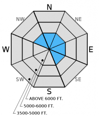
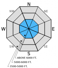
New snow and moderate to strong winds created fresh wind slabs. The avalanche danger is CONSIDERABLE on wind loaded slopes above 6000 feet. Human triggered avalanches are likely. The danger is MODERATE at mid elevations, and LOW below 5000 feet. Evaluate the snowpack and terrain carefully, and pay attention to temperatures warming more than expected. Persistent slab avalanches are possible where buried surface hoar and faceted snow near crusts 1 to 2.5 feet below the surface exist.

3. Considerable
?
Above 6500 ft.
2. Moderate
?
5000-6500 ft.
1. Low
?
3500-5000 ft.
- 1. Low
- 2. Moderate
- 3. Considerable
- 4. High
- 5. Extreme
-
Type ?
-
Aspect/Elevation ?

-
Likelihood ?CertainVery LikelyLikelyPossible
 Unlikely
 -
Size ?HistoricVery LargeLargeSmall

In the past 24 hours 4-6 inches of new snow fell across the area and likely more at higher elevations. Moderate to strong winds drifted the new snow and created slabs on the leeward sides of ridgelines and cross-loaded mid-slope terrain features. These slabs formed on a firm rain crust above 7000 feet in some locations that will provide an excellent sliding surface. In isolated areas these fresh wind slabs may sit on top of surface hoar formed earlier in the week. Carefully evaluate wind loaded terrain before committing to a slope.
In more sheltered terrain pay attention to thin storm slabs formed in the past 24 hours. The recent snow may start off loose and unconsolidated, but settle into a soft slab as temperatures rise. Sheltered and shaded areas are the most likely to harbor recently buried surface hoar. Keep in mind that terrain traps like treed areas, cliffs, and narrow gullies can amplify the consequence of small avalanches.
-
Type ?
-
Aspect/Elevation ?

-
Likelihood ?CertainVery LikelyLikelyPossible
 Unlikely
 -
Size ?HistoricVery LargeLargeSmall

Buried surface hoar and faceted snow about 1-2.5 feet from the surface exists. In upper elevation locations this has become a hard slab in many locations, and is increasingly more difficult to trigger. However, recent natural avalanches triggered by cornice fall within the past week show this is a low probability/high consequence scenario that should be treated with respect. A couple of these avalanches propagated far and wide (photo 1, photo 2). The additional stress put on these layers with new snow and wind drifted snow may cause them to become more reactive. These hard slabs are more likely to exist on previously wind loaded slopes. This weak layer is also spotty in distribution making it tricky to identify.
Weak snow surrounding the January 28 and January 17 rain crusts also exists 2-3 feet from the surface. Recent stability tests suggest that these weak layers are gaining strength, but its' still important to dig in the snow and do a stability test. Avoid areas where you are more likely to affect these layers like in shallow snow and in steep, rocky areas.
Anytime we inch toward the freezing mark or the potential exists to see the sun poke out it is important to pay attention to changing weather conditions. Warmer temperature than expected and sun can rapidly deteriorate conditions and increase the wet avalanche hazard. The snow surface becoming moist and pin wheels forming on steep slopes indicate that the surface snow is becoming unstable and you need to reassess the terrain you are traveling in.
Saturday: We were on Hash Mountain in the Swan Range and found the previous night's snow levels were higher than expected. At 7050 feet there was a rain crust with only 1-2 inches of snow on top. 10-15 mph winds were drifting the snow, there just was not much of it. We found the thin late January crust with weak snow around it 2.5 feet from the surface (photo). This layer did not fracture in our stability tests.
Friday: We were in McGinnis Creek in the southern Whitefish Range and found a wet snow surface up to at least 6000 feet. We noted a layer of decomposing buried surface hoar that was 6-10 inches from the surface that fractured in stability tests (observation).
Thursday: BNSF avalanche safety noted a moist snowpack, warm temperatures, and experienced collapsing on a southeast aspect with a shallow snowpack (observation). They also observed a cornice triggered slab avalanche on Mt. Cameahwait in the Flathead Range (photo), but are uncertain of the date of occurrence. Glacier Park rangers observed recent wet avalanche activity on the south aspects of Mt. Stanton yesterday (observation). Snowmobilers in Canyon Creek in the southern Whitefish Range also observed recent loose, wet avalanches (photo).
Wednesday: Erich found wet snow on sunny aspects with numerous small, wet loose sluffs (observation). We, along with other professionals and skiing parties in the southern Whitefish Range, observed widespread surface hoar formation (video, observations). Snowbikers in the Stryker Ridge area in the Whitefish Range also reported rollerballs, wet surface snow, and large surface hoar formation. A Two Bear Air Rescue pilot also observed cornice triggered recent wet, loose avalanche activity in the Swan Range on sunny aspects during a recent flight.
Visit our Observations page and our You Tube channel for more observations from the entire season.
Thanks to everyone for submitting observations. They are extremely useful and could help save lives.
HOW TO SUBMIT OBSERVATIONS:
Email: [email protected]
Call and leave a message: 406.387.3821
You can also submit quick observations via text: 406.241.4571 (FAC mobile)
OR
Submit Snowpack Observations: http://www.flatheadavalanche.org/node/add/snowobs
Submit Avalanche Observations: http://www.flatheadavalanche.org/node/add/avyobs
In the past 24 hours we picked up 4-6 inches of snow and 0.2-0.9 inches of snow water equivalent. Winds were out of the southwest at 10-25 mph with gusts from 23-44 mph. Currently, temperatures above 6000 feet range from 21º-28º F, and winds continue to blow out of the southwest at 4-14 mph with gusts from 7-23 mph. Today we should see decreasing snow showers and some breaks in the clouds early in the day. Temperatures will climb to the low 30s. Another wave of precipitation moves in to the area this evening and continues through tomorrow.
| 0600 temperature: | 21-28 deg. F. |
| Max. temperature in the last 24 hours: | 27-33 deg. F. |
| Average wind direction during the last 24 hours: | SW |
| Average wind speed during the last 24 hours: | 5-25 mph |
| Maximum wind gust in the last 24 hours: | 15-45 mph |
| New snowfall in the last 24 hours: | 4-6 inches |
| Total snow depth: | 64-93 inches |
This advisory applies only to backcountry areas outside established ski area boundaries. This advisory describes general avalanche conditions and local variations always occur. This advisory expires at midnight on the posted day unless otherwise noted. The information in this advisory is provided by the USDA Forest Service who is solely responsible for its content.


