| Friday | Friday Night | Saturday | |
|---|---|---|---|
| Cloud Cover: | Rain and snow. | Lowering snow levels. | Snow. |
| Temperatures: | 35 to 46 deg. F. | 25 to 33 deg. F. | 32 to 42 deg. F. |
| Wind Direction: | Southwest | Southwest | Southwest |
| Wind Speed: | 5-10 mph with gusts to 20 mph. | 10-15 mph with gusts to 25 mph. | 15-20 mph with gusts to 35 mph. |
| Snowfall: | 0-2 in. | 0-1 in. | 0-1 in. |
| Snow Line: |
Whitefish Range
Swan Range
Flathead Range and Glacier National Park
How to read the forecast
Rain up to 6000 feet and snow above will sustain heightened avalanche conditions. Human triggered wet loose avalanches and persistent slab avalanches are possible where buried surface hoar and faceted snow near crusts 1 to 2 feet below the surface exist. Pay attention to changing conditions as rain falls and snow levels rise today. Evaluate the snowpack and terrain carefully before committing to any slope. The danger is MODERATE at all elevations.

2. Moderate
?
Above 6500 ft.
2. Moderate
?
5000-6500 ft.
2. Moderate
?
3500-5000 ft.
- 1. Low
- 2. Moderate
- 3. Considerable
- 4. High
- 5. Extreme
-
Type ?
-
Aspect/Elevation ?
-
Likelihood ?CertainVery LikelyLikelyPossible
 Unlikely
 -
Size ?HistoricVery LargeLargeSmall

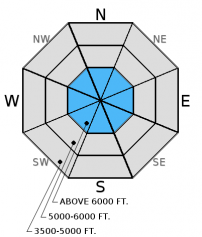
Strong winds and snow from last weekend created a slab that now sits atop buried surface hoar and faceted snow about 6-16 inches from the surface. In upper elevation locations this has become a hard slab in many locations, and is increasingly more difficult to trigger. These hard slabs are more likely to exist on previously wind loaded slopes. This weak layer is also spotty in distribution making it tricky to identify.
Weak snow surrounding the January 28 and January 17 rain crusts also exists 1.5-2.5 feet from the surface. Recent stability tests suggest that these weak layers are gaining strength, but a large load like a cornice fall or snowmobiles could be enough to awaken these layers. It still remains important to perform site specific snowpack evaluation due to the variability. Dig in the snow and do a stability test. Where they are present and there is any question about stability choose conservative terrain to ski or ride on. Avoid areas where you are more likely to affect these layers like in shallow snow and in steep, rocky areas. Avalanche professionals in southern Glacier Park experienced a collapse yesterday on a shallow snowpack on a southeast aspect; a clear sign of instability.
-
Type ?
-
Aspect/Elevation ?
-
Likelihood ?CertainVery LikelyLikelyPossible
 Unlikely
 -
Size ?HistoricVery LargeLargeSmall

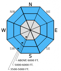
Rain at lower and mid-elevations will make both natural and human triggered loose, wet avalanches possible today. Rain weakens the surface snow similar to the way solar radiation and warm temperatures have done the past few days. Rollerballs and pinwheels are the first sign of surface instability with wet snow. If the skiing and riding conditions start to deteriorate due to wet surface snow, then move off of and out from under steep slopes. Even small wet slides can have big consequences in the wrong terrain like terrain traps.
-
Type ?
-
Aspect/Elevation ?
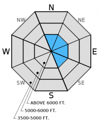
-
Likelihood ?CertainVery LikelyLikelyPossible
 Unlikely
 -
Size ?HistoricVery LargeLargeSmall

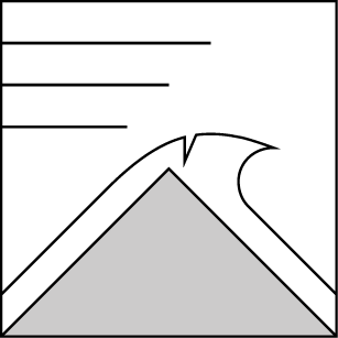
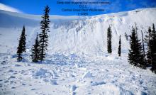
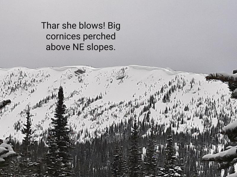
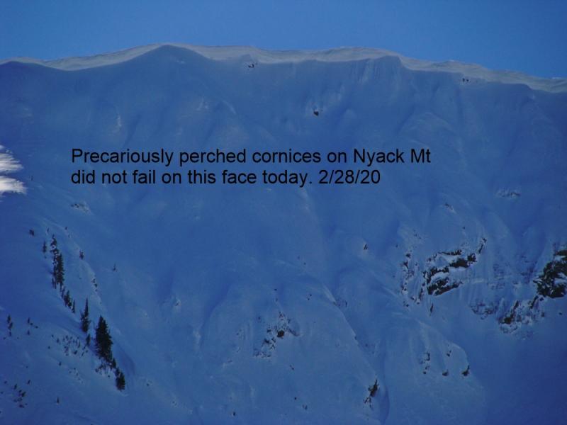
Warm temperatures and abundant sunshine over the past few days weakened cornices to the point of failure. Some of these cornices triggered both slab and wet, loose avalanches on the slopes below. BNSF Avalanche Safety observed a cornice triggered slab on Mt. Cameahwait that occurred within the past few days (photo). A climber in southern Glacier Park Wednesday noted a cornice fall that triggered a wind slab on steep east facing terrain (photo, observation), and a local pilot observed loose wet avalanches triggered by cornice fall in the Swan Range Tuesday. Cornice falls have the ability to trigger avalanches on any layer of concern in the snowpack (like wet loose, wind slabs, persistent slabs). Give cornices a wide berth and stay out from under them again today. I suspect cornices will be less sensitive today due to cooling at upper elevations, but with snow levels fluctuating they could still be a problem.
NOTE: If you are headed out today, it would be a good day to see how the recently formed surface hoar is doing. Rain will likely destroy the surface hoar at lower elevations, and the previous day's sunshine probably destroyed much of it on sunny aspects. However, there could be some lurking on shaded mid- and upper elevation slopes. Mentally mapping this layer before it gets buried is wise as it has the potential to become a problem in the future.
Thursday: BNSF avalanche safety noted a moist snowpack, warm temperatures, and experienced collapsing on a southeast aspect with a shallow snowpack (observation). They also observed a cornice triggered slab avalanche on Mt. Cameahwait in the Flathead Range (photo), but are uncertain of the date of occurrence. Glacier Park rangers observed recent wet avalanche activity on the south aspects of Mt. Stanton yesterday (observation). Snowmobilers in Canyon Creek in the southern Whitefish Range also observed recent loose, wet avalanches (photo).
Wednesday: My partner and I found wet snow on sunny aspects with numerous small, wet loose sluffs (observation). We, along with other professionals and skiing parties in the southern Whitefish Range, observed widespread surface hoar formation (video, observations). Snowbikers in the Stryker Ridge area in the Whitefish Range also reported rollerballs, wet surface snow, and large surface hoar formation. A Two Bear Air Rescue pilot also observed cornice triggered recent wet, loose avalanche activity in the Swan Range on sunny aspects during a recent flight.
Tuesday: We traveled to the Marion Lake area of the Flathead Range. We noted moist surface snow on sunny aspects with rollerballs and small point releases occurring throughout the day. Lingering wind slabs were present on leeward slopes. These wind slabs fractured but did not propagate in stability tests. We also were able to identify 3 natural wind slab avalanches from the weekend (observation).
Monday: Snowmobile rangers rode into the Mission Mountains just outside the advisory area and noted evidence of the recent wind event at all elevations. They found 2 layers of surface hoar in a north facing pit and also observed warm conditions and rollerballs/pinwheels at all elevations (observation).
Sunday: Skiers in the Apgar Range in southern Glacier Park noted numerous cornice failures along with possible wet slide debris at lower elevations. Wind slabs varied between non reactive to somewhat reactive. Skiing at lower elevations was "heavy and sloppy" (observation). The Patrol Fund Level 1 avalanche course at WMR in the southern Whitefish Range were able to get failure below the late January crust in compression tests with hard force. They also noted new surface hoar growth overnight (observation).
Visit our Observations page and our You Tube channel for more observations from the entire season.
Thanks to everyone for submitting observations. They are extremely useful and could help save lives.
HOW TO SUBMIT OBSERVATIONS:
Email: [email protected]
Call and leave a message: 406.387.3821
You can also submit quick observations via text: 406.241.4571 (FAC mobile)
OR
Submit Snowpack Observations: http://www.flatheadavalanche.org/node/add/snowobs
Submit Avalanche Observations: http://www.flatheadavalanche.org/node/add/avyobs
Rain and snow returned to the advisory area overnight. Today, rain will fall at lower and mid-elevations and could reach as high as 6000 feet. It appears we'll see rain this morning tapering before turning to snow tonight. Up to 0.25 inches of liquid could fall throughout the day. We could see 3-5 inches of snow at upper elevations by tomorrow morning. Currently,temperatures above 6000 feet range from 29º to 35º F and winds are moving out of the southwest at 1-8 mph with gusts to 12 mph. Today, temperatures will top out in the mid to upper 30s F with winds out of the south-southwest at 5-10 mph and gusts to 25 mph.
| 0600 temperature: | 29 to 35 deg. F. |
| Max. temperature in the last 24 hours: | 33 to 42 deg. F. |
| Average wind direction during the last 24 hours: | South-Southwest |
| Average wind speed during the last 24 hours: | 1-24 mph |
| Maximum wind gust in the last 24 hours: | 18-38 mph |
| New snowfall in the last 24 hours: | 1 inches |
| Total snow depth: | 59-90 inches |
This advisory applies only to backcountry areas outside established ski area boundaries. This advisory describes general avalanche conditions and local variations always occur. This advisory expires at midnight on the posted day unless otherwise noted. The information in this advisory is provided by the USDA Forest Service who is solely responsible for its content.


