| Sunday | Sunday Night | Monday | |
|---|---|---|---|
| Cloud Cover: | Isolated light showers early. Building high pressure. | Continued clearing. | Warming under high pressure. |
| Temperatures: | 26-34 deg. F. | 18-25 deg. F. | 32-41 deg. F. |
| Wind Direction: | W-SW | SW | SW |
| Wind Speed: | 5-7 | 7-12 gusts 25 | 5-11 gusts 24 |
| Snowfall: | 0 in. | 0 in. | 0 in. |
| Snow Line: |
Whitefish Range
Swan Range
Flathead Range and Glacier National Park
How to read the forecast
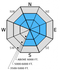
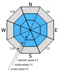
The avalanche danger is CONSIDERABLE on windloaded slopes above 6000 feet. Strong winds drifted recent snow and created slabs on leeward slopes and cross-loaded terrain features on multiple aspects. Human triggered avalanches are likely. All other terrain has a MODERATE danger. Carefully evaluate the snowpack for reactive persistent slabs. Also, pay attention to lingering windslab instability in terrain that is not typically wind affected.

3. Considerable
?
Above 6500 ft.
2. Moderate
?
5000-6500 ft.
2. Moderate
?
3500-5000 ft.
- 1. Low
- 2. Moderate
- 3. Considerable
- 4. High
- 5. Extreme
-
Type ?
-
Aspect/Elevation ?

-
Likelihood ?CertainVery LikelyLikelyPossible
 Unlikely
 -
Size ?HistoricVery LargeLargeSmall

Strong winds drifted recent snow and formed wind slabs on multiple aspects. In some areas these slabs formed over a recently buried layer of surface hoar (formed 2/3). In these areas instability will linger and avalanches have the potential to propagate far and wide. Look for obvious signs of instabilty like shooting cracks, whumpfing, and recent avalanche activity. Look for convex pillows of wind drifted snow on the lee sides of ridges and other cross-loaded terrain. Even unsuspecting slopes at lower elevations could harbor a wind slab today. Carefully evaluate all wind loaded terrain before traveling on or underneath the slope.
-
Type ?
-
Aspect/Elevation ?

-
Likelihood ?CertainVery LikelyLikelyPossible
 Unlikely
 -
Size ?HistoricVery LargeLargeSmall

Buried surface hoar now about 6 inches to a foot from the surface has produced the most recent activity, but is spotty in distribution. Deeper layers like the weak snow surrounding the the January 17 and January 28 rain crusts are buried 1.5-2.5 feet deep. Recent stability tests suggest that these deeper persistent slabs are gaining strength and are becoming more difficult to trigger. With that said it remains important to perform site specific snowpack evaluation. Dig in the snow and do a stability test, look for locally reactive slabs. Where they are present and there is any question about stability choose conservative terrain to ski or ride in. Avoid areas where you are more likely to affect these layers like in shallow snow and in steep, rocky areas.
With the ridge of high pressure building it is important to pay attention to changing weather conditions associated with warming and clearing. If the sun shines on a slope for extended periods and you notice the snow surface becoming moist it is time to move to a more shaded aspect. An early indication of rising surface instability is roller-balls/pinwheels forming on steep slopes and cutbanks.
Recent strong winds helped grow our local cornice population in size and quantity. Treat all cornices as suspect and stay far back from the edge. Cornice fall on slopes below are likely to trigger at least wind slabs today and potentially even deeper instabilities.
The final report for the 1/23/2016 avalanche fatality in Swede Creek in the Whitefish Range is complete and located here: http://www.flatheadavalanche.org/sites/default/files/20160124_swedecreekavalaccidentreport_final.pdf.
Saturday: Snowmobilers in the Stahl Peak area in the northern Whitefish Range observed recent natural avalanche activity. They noted wind drifting the snow at all elevations. While side hilling on a road cut they experienced cracking in the windslab 10-20cm deep (observation). We were in the Red Meadow area also in the northern Whitefish Range. Wind was drifting snow and forming wind slabs at all elevations (photo, video), and large cornices were developing along leeward ridgelines. We found weak snow around the January 28 crust that fractured in stability tests without propagation (observation).
Friday: Skiers in Crystal Creek/Stanton Lake in the Flathead Range intentionally triggered a windslab from the ridgeline (photo). They also noted active windloading forming slabs thicker than 2 feet deep (observation). Skiers on Snowshed Mountain also in the Flathead Range observed light winds with minimal drifting due to scoured windward slopes. They did note evidence of recent wind loading as knee deep soft slabs had formed on leeward slopes. Stability tests produced fractures with hard force on weak snow surrounding crusts 1.5-2 feet deep. They did not observe recently formed buried surface hoar in this location (observation). Snowmobilers in the 6-Mile area in the Swan Range noted substantial recent windloading. They did not see recent avalanche activity, but did experience other obvious signs of instability like cracking and collapsing (whumphing).
Thursday: Erich and I rode into Doris Ck. yesterday and were a bit suprised to see how much wind affected snow existed at elevations below 5000 ft. While the slabs weren't terribly large (6-10 inches deep), this clearly shows that they are thicker at mid and upper elevations. We also observed shooting cracks on small test slopes less than 35 degrees (observation, video). Skiers in the Essex Creek area of the Flathead Range also reported strong to extreme (>38 mph) winds with loose snow sluffs and shallow slabs on steep slopes as well (observation). Skiers in the Wahoo/Cascadilla area in the Flathead Range observed widespread cracking, shallow slabs at lower elevations, and signs of instability at all elevations as well.
Wednesday: Erich toured in Skookoleel and Lakalaho Creeks in the southern Whitefish Range yesterday where they found variable results in our numerous stability tests in a number of different pit locations (video, observation). They also found 3-5 mm surface hoar that formed Tuesday night. Skiers in the Middle Fork of the Flathead Range also observed surface hoar and a few layers in the upper snowpack that produced fracture in their stability tests (observation).
Visit our Observations page and our You Tube channel for more observations from the entire season.
Thanks to everyone for submitting observations. They are extremely useful and could help save lives.
HOW TO SUBMIT OBSERVATIONS:
Email: [email protected]
Call and leave a message: 406.387.3821
You can also submit quick observations via text: 406.241.4571 (FAC mobile)
OR
Submit Snowpack Observations: http://www.flatheadavalanche.org/node/add/snowobs
Submit Avalanche Observations: http://www.flatheadavalanche.org/node/add/avyobs
A few showers passed through the area yesterday along with strong winds with impressive gusts (up to 75 mph recorded at Hornet Weather Station). Currently, mountain temperatures range from 15º-20º F and winds are out of the west and southwest at 4-9 mph with gusts to 21 mph. Today we may see an isolated light snow shower early, but potential diminishes as a ridge of high pressure continues to build over the region. Temperatures are expected to rise to the upper-20s to low-30s today and winds will blow out of the west and southwest at 5-10 mph with gusts in the low-20s along ridgelines.
| 0600 temperature: | 15-20 deg. F. |
| Max. temperature in the last 24 hours: | 25-31 deg. F. |
| Average wind direction during the last 24 hours: | SW |
| Average wind speed during the last 24 hours: | 15-30 mph |
| Maximum wind gust in the last 24 hours: | 30-60 mph |
| New snowfall in the last 24 hours: | 0 inches |
| Total snow depth: | 63-96 inches |
This advisory applies only to backcountry areas outside established ski area boundaries. This advisory describes general avalanche conditions and local variations always occur. This advisory expires at midnight on the posted day unless otherwise noted. The information in this advisory is provided by the USDA Forest Service who is solely responsible for its content.


