| Thursday | Thursday Night | Friday | |
|---|---|---|---|
| Cloud Cover: | Rising temperatures. Light rain and snow possible late morning. | Mild with slightly cooling temps. | Warming with potential rain in the afternoon/evening. |
| Temperatures: | 34 to 39 deg. F. | 26 to 33 deg. F. | 35 to 44 deg. F. |
| Wind Direction: | Southwest | Southwest | Southwest |
| Wind Speed: | 5-10 mph with gusts to 25 mph. | 7-11 mph with gusts to 25 mph. | 6-11 mph with gusts to 30 mph. |
| Snowfall: | 0-1 in. | 0 in. | 0-2 in. |
| Snow Line: |
Whitefish Range
Swan Range
Flathead Range and Glacier National Park
How to read the forecast
The avalanche danger is CONSIDERABLE. New snow and wind over the past 36 hours, and warming above freezing today will maintain dangerous avalanche conditions. Recent natural and human triggered avalanches confirm that now is not the time to push it into steep terrain. Careful snowpack evaluation, cautious route-finding, and conservative decision making are essential. The low elevation danger could also rise higher today with warming temperatures as the day progresses. Pay attention to changing conditions.

3. Considerable
?
Above 6500 ft.
3. Considerable
?
5000-6500 ft.
2. Moderate
?
3500-5000 ft.
- 1. Low
- 2. Moderate
- 3. Considerable
- 4. High
- 5. Extreme
-
Type ?
-
Aspect/Elevation ?

-
Likelihood ?CertainVery LikelyLikelyPossible
 Unlikely
 -
Size ?HistoricVery LargeLargeSmall

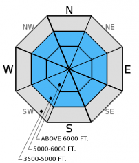
Storm Slab: All ranges received a lot of snow over the past week with the Swan Range receiving the lion's share of the precipitation (over 4 feet since last Wednesday). A new thin rain (or freezing mist) crust formed in many areas on top of weak cohesionless snow January 17th. It exists in the Flathead and Swan Ranges, at least. Up to 2 feet of new snow now rests on this crust. On Tuesday, this layer fractured and propagated in our stability tests. We observed shooting cracks yesterday on non-wind loaded slopes. Storm slab avalanches could fail within the new storm snow or at deeper interfaces like the thin January 17 crust. With warming today, storm and wind slabs will become more cohesive which could make them more sensitive to triggering. Storm slab avalanches could also step down into deeper persistent weak layers.
Wind Slab: Moderate to strong southwest winds over the past 48 hours formed sensitive wind slabs on leeward and cross-loaded slopes. Human triggered wind slabs up to 16 inches were reported and observed yesterday in the Whitefish and Swan Ranges. Recent avalanche activity is the most obvious sign of instability, and I expect wind slabs to still be sensitive today. Moderate to strong winds yet again today will build even thicker slabs. Fresh wind slabs have formed on top of a variety of surfaces including sun crusts, freezing rain crusts, buried surface hoar and currently onto recent storm snow. Yesterday's slabs broke within the storm snow, but thicker wind slabs on deeper layers are possible. Look for smooth, rounded features on the slope especially on steep convex rollovers, on leeward sides of ridges and cross-loaded gullies.
-
Type ?
-
Aspect/Elevation ?

-
Likelihood ?CertainVery LikelyLikelyPossible
 Unlikely
 -
Size ?HistoricVery LargeLargeSmall

There is a lot of variability across the advisory area with this problem that warrants careful snowpack evaluation and cautious route-finding. Surface hoar and weak faceted snow were observed in all ranges but you won't find them on all slopes. These weak layers are now 2.5 to 4.5 feet deep after the recent storm, and are still fracturing and propagating in stability tests. Surface hoar is notorious for propagating long distances across a slope, around corners, and through the trees. Given the tricky distribution of these persistent slabs it would be wise to avoid steep, open slopes and convexities. Look for obvious signs of instability like recent avalanche activity, shooting cracks, and whumpfing. The only way to know if these layers are reactive is to dig into the snow and perform stability tests.
-
Type ?
-
Aspect/Elevation ?

-
Likelihood ?CertainVery LikelyLikelyPossible
 Unlikely
 -
Size ?HistoricVery LargeLargeSmall

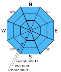
Temperatures will rise today into tomorrow. Since temps are relatively cool this morning it may take time for wet loose avalanches to occur, but human triggered and natural wet, loose avalanches could occur as the day progresses. This type of avalanche will become more likely tomorrow. Signs of instability include moist surface snow and roller balls forming on steep slopes and cutbanks. Loose, wet avalanches can knock you off your feet, or sled, and even entrain enough snow to bury you. Use extra caution when traveling near terrain traps like narrow gullies, steep treed areas, and cliffs.
We are saddened to hear the report of the fatality of a fellow avalanche professional near Big Sky, MT that occurred on Tuesday. Our thoughts are with family, friends, and all involved.
Yesterday, on Hash Mountain in the Lost Johnny drainage in the Swan Range, we were able to easily trigger three wind slabs on northerly aspects from the safety of the ridge above. All slabs were about 12-14 inches deep and propagated wide across each slope (video and observation). In our stability tests yesterday, the layer of facets and surface hoar below the 1/12 rain crust fractured and propagated as well (observation). We also observed a small natural avalanche at about 5200 feet that likely occurred within the past 24 hours (photo).
A skier just outside the boundary of Whitefish Mountain Resort reported triggering a wind slab on a north aspect up to 16 inches deep (observation), and no one was caught.
On Tuesday, Mark and I observed active wind loading throughout the day onto north and east aspects on Tunnel Ridge in the Flathead Range. On a north aspect we found a new, very thin rain crust that formed on January 17 and, at that time, was buried beneath 6 inches of surface snow. Stability tests resulted in fracture propagation with easy force below this crust and fracture propagation with hard force below the January 12 rain crust (observation, video, photo).
Also on Tuesday, BNSF avalanche safety noted active windloading on east and northeast aspects and windslab conditions on northeast - south aspects. They also observed shooting cracks and were able to intentionally trigger small soft slabs on leeward slopes (observation).
Visit our Observations page and our You Tube channel for more observations from the entire season.
Thanks to everyone for submitting observations. They are extremely useful and could help save lives.
HOW TO SUBMIT OBSERVATIONS:
Email: [email protected]
Call and leave a message: 406.387.3821
You can also submit quick observations via text: 406.241.4571 (FAC mobile)
OR
Submit Snowpack Observations: http://www.flatheadavalanche.org/node/add/snowobs
Submit Avalanche Observations: http://www.flatheadavalanche.org/node/add/avyobs
Storm totals (since Tuesday night) across the advisory area range from 8-12 inches with 0.3 to 1.9 inches of SWE. The precipitation mostly stopped by late yesterday morning. Within the past 24 hours, 2-4 inches accumulated throughout the advisory area. Winds were moderate to strong out of the southwest with the storm. Currently, mountain temperatures above 6000 feet range from 19º-25º F and winds are 5-15 mph out of the southwest. For today, expect temperatures to rise into the low 20s to mid-30s F. Wind speed will also increase again out of the southwest at 5-15 mph with gusts to near 40 mph (in locations close to the Continental Divide). Light rain/snow could occur throughout the day. Pay attention to changing weather conditions with warming and potential rain on snow and how this may affect stability.
| 0600 temperature: | 19 to 25 deg. F. |
| Max. temperature in the last 24 hours: | 23 to 29 deg. F. |
| Average wind direction during the last 24 hours: | Southwest |
| Average wind speed during the last 24 hours: | 5-15 mph mph |
| Maximum wind gust in the last 24 hours: | 21-33 mph |
| New snowfall in the last 24 hours: | 2-4 inches |
| Total snow depth: | 57-86 inches |
This advisory applies only to backcountry areas outside established ski area boundaries. This advisory describes general avalanche conditions and local variations always occur. This advisory expires at midnight on the posted day unless otherwise noted. The information in this advisory is provided by the USDA Forest Service who is solely responsible for its content.


